Miniature Golf in Ventura County
/According to Golflink.com, there are approximately 1,450 miniature golf courses throughout the United States, including 45 in the State of California. Overall, this equates to about 216,000 U.S. residents for each mini golf course. But California severely lags this statistic, with nearly 850,000 residents per mini golf course. Ventura County is in line with California overall in that it currently has a single mini golf course, Golf N' Stuff in Ventura, for a total of roughly 835.000 residents.

A look at the intimidating Hole 17 on course #2 at Golf N' Stuff in Ventura.
I have enjoyed Golf N' Stuff Ventura with my kids for years. It is the closest thing we have to an amusement park in Ventura County. With two 18 hole golf courses, bumper boats, bumper cars, go karts, laser tag and a well-appointed arcade, Golf N' Stuff Ventura has something for everyone. The golf courses are neat as they have such a varied assortment of decor, from a castle and a palace to an old country town, animals and more.

The old country western town at hole 10 of course 2. I love this hole.
With easy access from the 101 freeway off at Victoria Avenue, Golf N' Stuff is one of our favorite "staycation" activities. When it's 90 degrees in the Conejo Valley, we'll often find it a comfortable low 70s at Golf N' Stuff. And the facility is open 365 days a year (well, 366 days in leap years). Visit golfnstuff.com/ventura/info.html to learn more. And be sure to sign up with their Email Club to receive 2 for 1 golf coupons throughout the year.
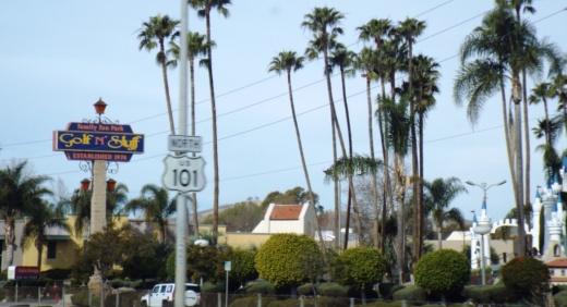
A view of Golf N' Stuff Ventura while driving the 101 North (as if you couldn't figure that out).
If you are a mini golf fanatic looking for other venues within about an hour drive of, say, Thousand Oaks, try the following:
Sherman Oaks Castle Park, run by the City of Los Angeles Department of Recreation and Parks www.laparks.org/castlepark
Arroyo Seco Golf Course in Pasadena www.arroyosecogc.com
Golf N' Stuff Norwalk golfnstuff.com/norwalk/info.html
California isn't one of the more popular mini golf states in the country, perhaps because there are SO MANY OTHER GREAT THINGS TO DO HERE!

The beautiful and iconic castle at Golf N' Stuff Ventura,