
Point Mugu State Park
/Point Mugu State Park is located in the Santa Monica Mountains, stretching from Newbury Park on the north to five miles of ocean shoreline on the south. The park includes 14,000 acres of land with over 70 miles of trails popular with hikers, cyclists and runners. It is truly an amazing place, with rocky peaks that include the prominent Boney Mountain State Wilderness that looks over the western Conejo Valley.

The sign in Rancho Sierra Vista/Satwiwa in Newbury Park indicating you are entering State-managed Point Mugu State Park.
You can actually hike, run or bike from Newbury Park, from the Rancho Sierra Vista/Satwiwa area managed by the National Park Service down to the ocean via Sycamore Canyon "Sycamore to the Sea," which is about an 8 mile trip one way. But do be aware - the initial 800 foot drop from Rancho Sierra Vista into the canyon via Big Sycamore Canyon Road is a bit more challenging coming back up.

The paved hill drops into the canyon via Sycamore Canyon Fire Road.
There are four main canyons in Point Mugu State Park. Sycamore Canyon is perhaps the most well known, stretching practically the entire north/south length of the park, where at the bottom of the canyon you'll find the 58 space Sycamore Canyon Campground at 9000 W. Pacific Coast Highway (make reservations at ReserveCalifornia.com and search for “Point Mugu SP”).

The Sycamore Canyon Campground connects to the Sycamore Canyon Fire Road, which is your access point to a day of fun and adventure in Point Mugu State Park trails.
The La Jolla Valley Natural Preserve is on the western side of the park, with a main access point near Thornhill Broome State Beach at the Ray Miller Trailhead to the La Jolla Canyon Trail which connects with the Loop Trail. Another access point to La Jolla Valley is the Chumash Trail trailhead, a rocky, steep trail across from Point Mugu Beach. La Jolla Valley was purchased by the State of California in 1966 and was established as a Natural Preserve in 1972.
Wood Canyon is in the northwest section of the park, where you will find the north/south running Wood Canyon Fire Road, which connects to the Guadalasca Trail, among others.
Serrano Valley is accessible from the south off the Big Sycamore Canyon Fire Road/Trail about a mile north of the beach. A beautiful, serene, area, with a connection to the Old Boney Trail that takes you to the Danielson Monument in the Boney Mountain Wilderness.
The main beach areas in Point Mugu State Park, running southeast to northwest, are Sycamore Cove, Thornhill Broome and Point Mugu. Sycamore Cove is a fun day-use park popular with families for gatherings with BBQ grills and picnic tables. Learn more about beaches in the Malibu area at this link.

This is the PCH overpass where on low tide you can walk underneath here to get from Sycamore Cove Beach to Sycamore Canyon Campgrounds and hiking in Point Mugu State Park. In higher tides, this area can be dicey, so be careful.
If you are looking for beachfront camping, try Thornhill Broome Beach, with just over 60 spots available for RVs and tents. No hookups here and only porta-johns available, but can't beat the views! And across the street you can't miss the Giant Sand Dune!
Day use parking at the various sites is available for $12. There is very minimal street parking at Sycamore Cove but plenty of street parking adjacent to Thornhill Broome Beach.
Dogs on a leash are allowed in the Park's day use areas, campgrounds and beaches. Dogs are not allowed on the back country trails or dirt roads.
Keep driving northwest on PCH and you'll past the famous Mugu Rock and see Pt. Mugu Beach, which also has day use parking, with some parking on PCH. Learn more at the California State Parks website at www.parks.ca.gov/?page_id=630.

Mugu Rock up ahead, driving north on PCH from Thornhill Broome.
Lastly, let's cover some of the highest peaks in Point Mugu State Park. The Boney Mountain Wilderness Area, ever so prominent from the Conejo Valley, is located in the Park. But Boney Peak itself, at 2828 feet, is actually in the Circle X Ranch area managed by the National Park Service, along with Sandstone Peak, the highest spot in the Santa Monica Mountains at 3111 feet.

Boney Mountain range overlooks the western Conejo Valley.
Other peaks include Tri Peaks at 3010 feet, Laguna Peak (the peak which has equipment from Naval Base Ventura County below), La Jolla Peak and Mugu Peak.
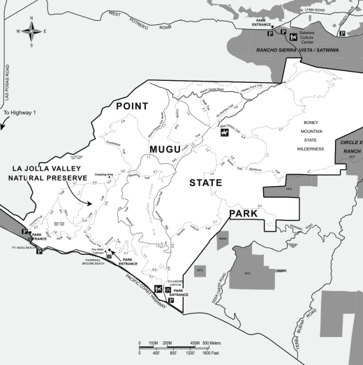
Map of Point Mugu State Park courtesy of National Park Service.
