
Boney Mountain Trail to Hidden Valley Overlook, Danielson Monument and Waterfall
/At Rancho Sierra Vista/Satwiwa in Newbury Park is a nice assortment of trails that reward hikers with beautiful views and peaceful surroundings. Find your way to the Satwiwa Native American Culture Center and from there walk up Big Sycamore Canyon Road where you'll reach a fork in the road. If you go straight you'll be taking Big Sycamore Canyon road about 6-7 miles down to Sycamore Canyon Campground and Sycamore Cove Beach. The road is paved for about 3 miles until it intersects the Backbone Trail, at which point it is dirt trails to PCH.

Benches at the top of Big Sycamore Canyon Road.

Views from the benches looking down Big Sycamore Canyon. Photo taken a few months before the Springs Fire of 2013.

View of Big Sycamore Canyon after the Springs Fire of 2013.
Getting back to the benches at the top of Sycamore Canyon, looking off to the east you'll find the Boney Mountain Trail sign that takes you towards the Hidden Valley Overlook, Waterfall and Danielson Monument, a .4 mile, 1 mile and 2.2 mile one way hike, respectively.


Boney Mountain Trail sign in Rancho Sierra Vista post-Springs fire 5/5/13.
Take the trail to the fork in the road. A sharp left takes you directly back to the Satwiwa Center, a "normal" left takes you on a trail towards Wendy Drive and/or back to the Satwiwa Center in a loop, and a right turn takes you up the hill towards the destinations mentioned above.
A short walk up the trail gets you to yet another bench that overlooks Sycamore Canyon from another angle. This is called the Sycamore Canyon Overlook.

This photo of the Sycamore Canyon Overlook was taken before the Springs Fire of 2013.

Bench at Sycamore Canyon Overlook on 5/14/13.
The rocky trail from there takes you to a fork. Veer LEFT to the Hidden Valley Overlook trail or right to the Danielson Monument and Waterfall (as well as the Old Boney Trail).

The Hidden Valley Overlook trail is rocky, pretty steep in some sections and a bit challenging. But...you will be rewarded with some nice views of Dos Vientos, Camarillo and eventually an "overlook" of Hidden Valley.

Endpoint of the Hidden Valley Overlook trail, peering into Hidden Valley. This photo was taken in April 2014.
If you veer right at the fork in the trail, after a .4 mile jaunt down the hill you'll see a sign that tells you you're getting close the waterfall. There are lots of rocky sections as well as crevices as you make your way down this trail, so do be careful. But it is fairly wide most of the way.

Sign at bottom of hill indicating you distance to waterfall trail and danielson monument
There's a stream crossing that most of the year is easy to get across as there's not a lot of water in it, although in particularly rainy winters it can get more challenging in the winter/spring.

Mostly mud in the stream crossing that gets you to the Danielson Monument in mid-February 2013, but some years there's more water in there (like 2017, after the winter rainstorms).
So after you cross the stream, you're off on a mostly narrow, single-track trail. Watch out for poison oak on the sides of the trails. I usually run up here in shorts, but you're much safer wearing long pants. The next juncture in the trail, you go straight to the waterfall, or veer right up to the Danielson Monument.

We've been to the waterfall when it had a lot of water flowing in it. This year (2013) there's barely a trickle.
So if you take the sharp right hand turn, you're on your way to the Danielson Monument (a tribute to Richard Ely Danielson, Junior, who lived on land in this area for 32 years with his family, until it was sold to the National Park Service in 1980). Awesome views from several vantage points as you head up the trail. A bit of a climb. Be prepared! Check out other photos of the monument HERE and larger pics HERE.

Danielson Monument
About 4/5ths of the way from the bottom of the canyon to the Danielson Monument, you can veer right to the Old Boney Trail, an interesting, mostly single track trail that has great views of Boney and intersects with the Fossil Trail.
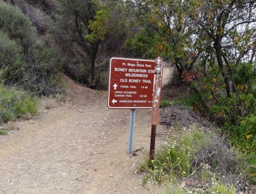
Here's the sign at the juncture of the Danielson Road trail and the Old Boney Trail turnoff, about .3 mile away from the Danielson Monument.
