State of California Smog Check Program Requirements

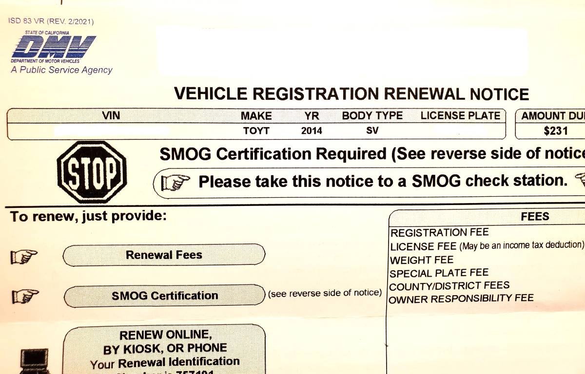
I was about to renew my auto registration online as I’ve done mindlessly for many years, until I looked more carefully at the notice and I read the dreaded “STOP: SMOG Certification Required” imprinted near the top of the notice. I’ve owned the minivan for eight years and wondered, why NOW!?

The California Smog Check Program has been in place since 1984 and is administered by the Bureau of Automotive Repair, or BAR. BAR licenses independently owned smog check stations throughout the state.

THE BASICS

The BAR indicates a smog check is required EVERY OTHER YEAR as part of the vehicle registration process. It is also required when a vehicle changes ownership or when it is registered for the first time in California.

Every other year? That can’t be, because this was the first time I’ve been asked to do a smog check in the eight years since I owned the car, right?

The BAR goes on to explain that gasoline-powered vehicles, hybrid vehicles and alternative-fuel vehicles that are model year 1976 and newer require a smog check, with the following exceptions:

  • Eight model years and newer do not require a biennial smog check.

  • Four model years and newer do not require a change-of-ownership check.

In English, this means you need to add 8 to the model year of your vehicle to determine when you need to start doing biennial, or every other year, smog checks. For example, my 2014 minivan needed a smog test starting in 2022. And if I purchase a used 2018 vehicle in 2022, it would be subject to a smog check.

SMOG CHECKS ARE NOT REQUIRED FOR:

  • 1975 or older vehicles

  • Eight model years or newer vehicles

  • Four model years or newer vehicles changing ownership

  • Electric vehicles

  • Motorcycles

  • Tricycles (OK, I decided to throw this in to make sure you were paying attention.)

  • Diesel vehicles model year 1997 and older

  • Diesel vehicles with a gross weight of over 14,000 pounds

OTHER

Wait a second, my 2014 minivan is eight years old. Why this year, not next year, for the first smog check? Because the state assumes that model years are released in the calendar year prior to a vehicle’s model year. So regardless whether I purchased my brand new 2014 minivan in 2013 or 2014, it is assumed to be one model year old in 2014. That means, it is theoretically turning nine model years old in 2022. Hence, the need for a smog check for the first time in 2022.

If your smog check passes, hurray! The smog “certificate” is electronically submitted to the DMV and you are on your way to renew your vehicle registration. If it fails the test, you need to get it fixed, or you can visit a “smog check referee” for a second opinion.

“But I don’t want to get a smog check!” Well, then buy an electric car or a model 1975 or older car. Or buy a new car before your car turns eight model years old. Or move to a state like Alabama that doesn’t require emissions testing.

Take Advantage of AAA Membership Benefits and Discounts

AAA_logo.png

The Automobile Club is a non-profit service organization with over 51 million members, including 6 million in Southern California.  If you are not already a member, you should consider becoming one.

Basic “classic” membership is $57 per year (as of June 2025). Membership provides for up to 4 service calls per year, with tows up to 7 miles, discounted rental cars, emergency fuel delivery, locksmith service, access to AAA offices and services, free maps and travel planning, etc. Upgraded plans (AAA Plus and AAA Premier) are available, with enhanced benefits, such as much longer towing benefits.

But where membership can really pay off are savings on products and services.  Here are a few that really stand out (updated June 2025...subject to change).

  • Getting a AAA rate on hotels like Hilton, Hyatt, and Best Western can save you 5% or more on your rooms.

  • AMC Theatre Black Tickets good for seats across the country for $12.75, which is a 20% savings over average retail prices. Also save on tickets at Regal and Cinemark theatres.

  • $2 off admission to the Kidspace Children’s Museum in Pasadena.

  • Save over 40% on admission at Knott's Berry Farm.

  • Up to 20% off when you purchase advance tickets to Aquarium of the Pacific in Long Beach at an AAA branch and 10% off at the gate or online.

  • Save 30% on a 1-day general admission to Universal Studios Hollywood

  • Save up to 56% off passes to Six Flags Magic Mountain.

  • Save 5% at the gate at LEGOLAND California Resort and up to 20% off of tickets purchased in advance

  • Save up to 60% on tickets to Sea World San Diego

  • Planning on a multi-day visit to Disneyland? Save by buying passes at a AAA office

  • 10% off food and non-alcoholic drinks at Dave & Buster’s

Hundreds more discounts listed on the AAA website. There's also a free AAA iPhone and Android app to find AAA discounts in your area.

So even if you don't think you'll need roadside assistance or towing, it could really pay off having a AAA membership.  Visit the Auto Club of Southern California website at www.calif.aaa.com/home.html for more information.

State Route 23 Between the 101 and 118 is Dedicated to Japanese American World War II Soldiers

Moorpark Freeway section of SR 23 taken from Marview Trail in Thousand Oaks.

Moorpark Freeway section of SR 23 taken from Marview Trail in Thousand Oaks.

State Route 23 stretches from Malibu to Fillmore in three sections. The south section is the winding, hilly Decker Canyon Road that connects Pacific Coast Highway to Westlake Village and Hidden Valley. This section is approximately 10 miles from PCH to the Potrero Road intersection, but generally takes 20 to 25 minutes to drive.

SR 23 continues as Westlake Boulevard to the Ventura Freeway (U.S. Route 101), where it runs concurrent with the 101 north a couple miles until you reach the Moorpark Freeway overpass. This is another 4 to 4 1/2 miles.

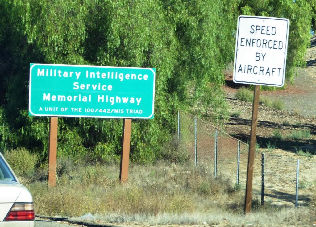
The most visible section of SR 23 in Thousand Oaks is the Moorpark Freeway, which stretches from the 101 to the Los Angeles Avenue exit in Moorpark; about 8 miles. This middle section of the 23 was named the Military Intelligence Service Memorial Highway in 1994 by the California State Assembly. The renaming was made in honor of Nisei, or Japanese American, Soldiers of World War II who served in units of the U.S. Armed Forces comprising the 100/442/MIS triad (Military Intelligence Service, 100th Infantry Battalion and 442nd Regimental Combat Team). **

Military Intelligence Service Memorial Highway sign

Military Intelligence Service Memorial Highway sign

The northern section of SR 23 begins at Los Angeles Avenue (SR 118) in Moorpark and goes north as Grimes Canyon Road, ending at SR 126 in Fillmore. This is about a 12 mile stretch includes some eye opening, hilly twists and turns in the Grimes Canyon Road area.

The total length of SR 23 is about 32 miles.

** Some additional clarification from the 1994 legislation: Segments of State Highway Routes 23 and 99 are officially designated as follows: (a) State Highway Route 23, from Highway 101 to Highway 118, as the Military Intelligence Service Memorial Highway. (b) State Highway Route 99, between the Cities of Fresno and Madera, as the 100th Infantry Battalion Memorial Highway. (c) State Highway Route 99, between the Cities of Salida and Manteca, as the 442nd Regimental Combat Team Memorial Highway. Each of the signs to also include "A unit of the 100/422/MIS triad.

Fireworks Hill in Thousand Oaks Has Hosted the City's Fireworks Show for Decades

So called "Fireworks Hill" is located in the center of Thousand Oaks, enveloped by McCloud Avenue on the northwest, St. Charles Drive on the northeast, Wilbur Road on the east, Marin Street on the south and Hillcrest Drive on the southeast.

The hill is passed by tens of thousands of commuters each day as it can clearly be seen from the 101. 

For decades, the annual City of Thousand Oaks 4th of July Fireworks have been launched from this hill, a 27 acre parcel that was acquired by the City of Thousand Oaks in 1994. According to an April 7, 1994 Los Angeles Times article, the top of the hill was graded three decades prior.

According to minutes from the April 5, 1994 City Council meeting, city council voted by a 3 to 2 vote to acquire the property from the Robert A. Franklyn Estate for $540,000, plus $5,000 in estimated escrow closing costs.

The fireworks launched from this site can be seen from quite a large radius in the surrounding area. Here's to a great Independence Day!

Independence Day events and activities throughout Ventura County

Fireworks Hill shown here in early January 2016, when three were snow capped peaks in the background.

Fireworks Hill shown here in early January 2016, when three were snow capped peaks in the background.

The Story Behind Those Historic El Camino Real Bell Markers on the 101 Freeway

Like me, perhaps you've wondered about those unique bell markers seen frequently on the 101 Freeway with the sign that says "Historic El Camino Real."

One of those ubiquitous Historic El Camino Real bell markers we see along the 101 Freeway.

One of those ubiquitous Historic El Camino Real bell markers we see along the 101 Freeway.

El Camino Real is Spanish for "The Royal Road" and in California is the name for the 700 mile historic California Mission Trail that connects 21 missions, 4 presidios (military forts) and several pueblos (towns) from Mission San Diego de Alcala in the south to Mission San Francisco Solano in Northern California. El Camino Real is designated as California Historical Landmark #784.

California State Assembly Bill 1707 defined the El Camino Real route, which includes portions of Routes 280, 82, 238, 101, 5, 72, 12, 37, 121, 87, 162, 185, 92, and 123 and connecting city streets and county roads in a continuous route from Sonoma southerly to the international border.

So what's up with those bell markers on the 101? According to the California Department of Transportation, the Mission Bell Marker system has existed on the historic El Camino Real route since 1906. The original marker system called for installation of bells one mile apart along the entire length of the El Camino Real. By 1913, over 450 markers were in place, but over the years the bells were removed due to damage, vandalism and theft. In 1959, the Division of Highways was legislatively mandated to maintain the marker system. Legislation in 1974 reiterated that responsibility.

Caltrans initiated a plan to maintain the system beginning in 1974, when less than 100 of the original Mission Bell Markers remained. The bells are exact copies of the original 1906 bells; in fact, the original bell molds were used to fabricate the new bells. Mission Bell Marker locations were chosen based on safety, constructability, visibility and scenic quality of the site. Spacing between marker locations varied based on existing site conditions and limitations. An average spacing of 1 to 2 miles was sought when identifying the locations.

The Caltrans Landscape Architecture Program began in 1996 to fulfill its vision to restore the historic El Camino Real Mission Bell Marker system from San Diego to Sonoma. The portion of the system from San Diego to Los Angeles was not addressed by the restoration project because those bells are mostly located on local streets outside of the State’s jurisdiction. The first phase of the restoration project, between Los Angeles to San Francisco, was completed in early 2005. The second and final phase of the restoration project was completed between San Francisco and Sonoma in late 2012. The Mission Bell Marker system as originally envisioned in the earlier part of the last century has finally been realized!

Caltrans received nearly $2 million in Transportation Enhancement grants to fund restoration of the Mission Bell Marker system on the El Camino Real from Orange County to Sonoma. Funding was received for the manufacture and placement of 585 Mission Bell Markers, placed approximately one to two miles apart along the roadside in the northbound and southbound directions of State Routes 101, 82, 37, 121, and 12. Mission Bell Markers located within the roadside of a state route are maintained by Caltrans. Maintenance of Markers located on local streets are the responsibility of the local entity.

So that explains why you see all of those interesting bell markers on the 101 Freeway! How would you like to have one of these authentic California El Camino Real Bell Markers in your own yard!? Visit the California Mission Bell company website at www.californiabell.com.

Older El Camino Real bell marker on display at the Old Mission Santa Barbara.

Older El Camino Real bell marker on display at the Old Mission Santa Barbara.

Mugu Rock at Point Mugu

Point Mugu is an unincorporated part of Ventura County that is derived from the Chumash word Muwu, or beach. Other than the Naval Base, probably the most well known fixture in Point Mugu is the Mugu Rock. Mugu Rock is a large rock formation that was formed when Pacific Coast Highway was built and cut through the mountain that now resides on the other side of PCH. Before PCH was built, a road went around the rock, where a chain link fence has been placed to keep people away from this hazardous area adjacent to the Pacific Ocean.  PCH was cut through Point Mugu from October 1937 to February 1940, according to this interesting KCET article.

MuguRock_pch.JPG

Mugu Rock is located just a few miles near the northwest tip of PCH before it veers north towards Oxnard. It is about a 10 mile drive from the Camarillo Premium Outlets and about 20 miles from the heart of Thousand Oaks taking either the 101/Lewis Road route or the slightly slower, curvy and interesting Potrero Road route.

Professional landscape and wildlife photographer Greg Clure of Newbury Park has shared a couple neat images facing Mugu Rock from the south. Visit Greg's website at www.gregclurephotography.com for more of his outstanding work.

ClureMuguRock2.jpg
ClureMuguRock1.jpg

And here is some not so professional video footage of Mugu Rock from the north.

Seven Flat, Stroller and Family Friendly Hikes in the Conejo Valley

There is a ring of about 15,000 acres of open space with 140 miles of trails for public use surrounding the Conejo Valley. All too often on the Conejo Valley Guide Facebook Page we hear requests for which trails are "stroller friendly" and/or suitable for young children. Here is a sampling of some of the more popular ones in the area.

Wildwood Park to many is the single greatest spot for family hikes and stroller-friendly trails. With 14 trails covering 17 miles, including the popular hike to Paradise Falls and the teepee as well as some wide, relatively flat sections along the Mesa Trail towards Lizard Rock.

It takes a bit of driving via the Norwegian Grade and Santa Rosa Road to get there, but the Conejo Canyons Open Space in the Western Plateau section of the Conejo Open Space leads to several miles of nice, flat, well-maintained family-friendly trails leading to tree-canopied picnic areas. The Hill Canyon Trail and Hawk Canyon Trail are very easy to navigate.

Shaded picnic area off the Hawk Canyon Trail from the Conejo Canyons Bridge.

Shaded picnic area off the Hawk Canyon Trail from the Conejo Canyons Bridge.

The one mile Spring Canyon Trail is a mostly flat trail that runs from Lynn Oaks Park, 359 Capitan Street, Newbury Park to the Los Robles Trail.  There are some moderate hills but with the park nearby, this makes for a fun little excursion with the little ones. (No restrooms, however.)

The main access point to the Los Robles Trail at the southern endpoint of Moorpark Road at Greenmeadow Ave starts out with a reasonably flat section that is a nice, easy family stroll.

Speaking of the Los Robles Trail, another great little hike to take with the kids is the Oak Creek Canyon Loop Trail. The first 4/10th of a mile of the trail, accessible off of Greenmeadow Avenue in Thousand Oaks, is the Oak Creek Canyon Whole Access Interpretive Trail. This is a nice, shady, flat trail with benches and picnic benches along the path. The remainder of the loop is not quite as stroller friendly, with a couple moderately steep sections that can be navigated on foot.

Picnic trails and shade abound at the Oak Creek Canyon Interpretative Trail.

Picnic trails and shade abound at the Oak Creek Canyon Interpretative Trail.

The Rancho Sierra Vista/Satwiwa area managed by the National Park Service in Newbury Park has several miles of trails to explore, most of which are flat and stroller-friendly. The Satwiwa Loop Trail takes you around the area and the Satwiwa Native American Indian Culture Center makes for a fun stop with the family when open on weekends.

The Chumash home, or “‘Ap,” in the background. The one pictured has since been replaced.

The Chumash home, or “‘Ap,” in the background. The one pictured has since been replaced.

Cheeseboro/Palo Comado Canyons offer great family hiking opportunities. While there's definitely hills surrounding these canyons, try the Cheeseboro Canyon Trail, the 4 to 5 mile main artery into the park. Flat and kid/stroller friendly it is. Also try the Doubletree Trailhead connector to the Palo Comado Trail. Flat, fun and scenic.

The Los Padres Trail in Thousand Oaks is a short trail, half of which is pretty flat and tree lined, if you’re looking for a short excursion with a toddler. A seasonal creek makes it even more interesting as you may hear froggies in the spring.

PaloComadoSign.JPG

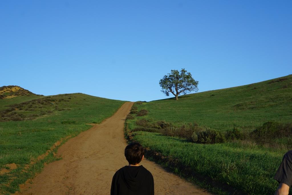
Although the trails in the Lang Ranch/Woodridge Open Space in Thousand Oaks are NOT FLAT and indeed quite HILLY, they are worth checking out with the kids because they wide and have some interesting sandstone rock formations. If you are really strong, strollers are possible here, but do know that you will encounter some hills like the hill shown in the image below.

This hill in the Lang Ranch/Woodridge Open Space at the Autumn Ridge Trail is a bit daunting but worth the climb.

This hill in the Lang Ranch/Woodridge Open Space at the Autumn Ridge Trail is a bit daunting but worth the climb.

We're going to throw a bonus trail into the mix. The several miles of hiking trails in the Oakbrook Regional Park Archaeological Area in Thousand Oaks is an outstanding place for a flat, picturesque and oak-tree canopied place for a short hike with the kids.

For a more comprehensive compilation of trails in the Conejo Valley and throughout Ventura County, visit THIS LINK.