The Ventura County Portion of State Highway Route 1 is Named "Ventura County Vietnam Veterans Memorial Highway"

California State Route 1 runs along most of the coastline of California and at 656 miles is the longest state route in California. The section of SR 1 between I-5 in Dana Point and the US 101 near Oxnard is designated Pacific Coast Highway.

Sign at the indicating the north end of southbound PCH, where it connects to Las Posas Road.

Sign at the indicating the north end of southbound PCH, where it connects to Las Posas Road.

In 2002, the state assembly voted to designate the section of State Highway Route 1 in Ventura County as the “Ventura County Vietnam Veterans Memorial Highway” in gratitude and appreciation for the sacrifices California Vietnam veterans.

VC Vietnam Veterans Highway1.JPG

That same bill also designated the portion of State Highway Route 126 between the City of Santa Paula and State Highway Route 101 as the Korean War Veterans Memorial Highway.

U.S. 101 in Ventura County is Designated "The Screaming Eagles Highway"

Screaming Eagles Sign.JPG

As you drive U.S. Route 101 northbound in the Conejo Valley just past the Westlake Boulevard offramp, you’ll see a sign that says "The Screaming Eagles Hwy 101st Airborne Division."

The sign was authorized by Assembly Concurrent Resolution No. 54 (ACR-54) Screaming Eagles Highway: 101st Airborne Division, in 2003.

The 101st Airborne Division ("Screaming Eagles") is a specialized modular light infantry division of the U.S. Army trained for air assault operations. It was formed in World War I on July 23, 1918 and has been involved in every major U.S. war since then.

The 101st Airborne Division was instrumental in the success of the D-Day Invasion, the Operation Market Garden in Holland, in Bastogne for the Battle of the Bulge, in Vietnam for Operation Nevada Eagle, and in many other courageous missions worldwide. 

In recognition of the 101's significance for military personnel of the 101st Airborne Division, the Assembly designated the 44 mile section of the 101 in Ventura County as the Screaming Eagles Highway.

The sign was unveiled in September 2005. The same sign is placed on the southbound 101 just south of the Bates Road offramp on the Ventura/Santa Barbara County border.

Building Pacific Coast Highway Around Point Mugu in 1923-1924

Point Mugu before and after creation of a narrow road around it in 1924.

Point Mugu before and after creation of a narrow road around it in 1924.

According to the California Highway Commission in the October 1924 issue of “California Highways,” perhaps the most dangerous and difficult piece of construction work on the California state highway system at that time was the 3800 feet of grading AROUND Point Mugu.

For those driving Pacific Coast Highway in Ventura County past Mugu Rock, there are clear signs of this old route that took automobiles on a precarious route around Point Mugu.

Peaking through the fence towards the old road around Mugu Rock.

Peaking through the fence towards the old road around Mugu Rock.

The new and still existing route was created by blasting a massive hole through Point Mugu to create Mugu Rock in 1937 to 1940.

The work to complete this section of the Oxnard to San Juan Capistrano PCH route was authorized by a bond issue in 1919.

The project averaged 60 workers who moved 108,000 cubic yards or rock at a total cost of $108,500 (heck, that would be the cost of a pool addition and new kitchen remodel today). The cut around Point Mugu ranged from 40 feet on the ocean side to 115 feet on the high side in creating the narrow, short-lived roadway.

The California Highway Commission ended its article by stating “…along this piece of rugged coast line the Old Pacific is recognized as an arch enemy to whom we must trust as little as possible of our costly highway.” Sheesh, that was not a particularly optimistic statement!

State Route 23 Between the 101 and 118 is Dedicated to Japanese American World War II Soldiers

Moorpark Freeway section of SR 23 taken from Marview Trail in Thousand Oaks.

Moorpark Freeway section of SR 23 taken from Marview Trail in Thousand Oaks.

State Route 23 stretches from Malibu to Fillmore in three sections. The south section is the winding, hilly Decker Canyon Road that connects Pacific Coast Highway to Westlake Village and Hidden Valley. This section is approximately 10 miles from PCH to the Potrero Road intersection, but generally takes 20 to 25 minutes to drive.

SR 23 continues as Westlake Boulevard to the Ventura Freeway (U.S. Route 101), where it runs concurrent with the 101 north a couple miles until you reach the Moorpark Freeway overpass. This is another 4 to 4 1/2 miles.

The most visible section of SR 23 in Thousand Oaks is the Moorpark Freeway, which stretches from the 101 to the Los Angeles Avenue exit in Moorpark; about 8 miles. This middle section of the 23 was named the Military Intelligence Service Memorial Highway in 1994 by the California State Assembly. The renaming was made in honor of Nisei, or Japanese American, Soldiers of World War II who served in units of the U.S. Armed Forces comprising the 100/442/MIS triad (Military Intelligence Service, 100th Infantry Battalion and 442nd Regimental Combat Team). **

Military Intelligence Service Memorial Highway sign

Military Intelligence Service Memorial Highway sign

The northern section of SR 23 begins at Los Angeles Avenue (SR 118) in Moorpark and goes north as Grimes Canyon Road, ending at SR 126 in Fillmore. This is about a 12 mile stretch includes some eye opening, hilly twists and turns in the Grimes Canyon Road area.

The total length of SR 23 is about 32 miles.

** Some additional clarification from the 1994 legislation: Segments of State Highway Routes 23 and 99 are officially designated as follows: (a) State Highway Route 23, from Highway 101 to Highway 118, as the Military Intelligence Service Memorial Highway. (b) State Highway Route 99, between the Cities of Fresno and Madera, as the 100th Infantry Battalion Memorial Highway. (c) State Highway Route 99, between the Cities of Salida and Manteca, as the 442nd Regimental Combat Team Memorial Highway. Each of the signs to also include "A unit of the 100/422/MIS triad.

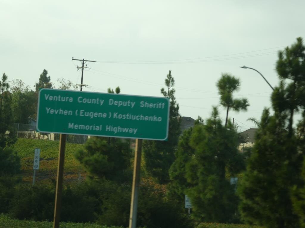
Ventura County Deputy Sheriff Yevhen "Eugene' Kostiuchenko Memorial Highway in Camarillo

Kostiuchenko Mem Highway.JPG

California State Assembly Concurrent Resolution No. 14 filed with the Secretary of State on July 21 2015 honors the life of Ventura County sheriff who was struck and killed by a drunk driver on October 28, 2014.

The Legislature designated a 2.04 mile portion of Highway 101 between Lewis Road/State Route 34 at mile post 13.848 and Las Posas Road at mile post 15.888 as the Ventura County Deputy Sheriff Yevhen “Eugene’ Kostiuchenko Memorial Highway.

Other information about Deputy Kostiuchenko:

  • He was born in the Ukraine in January 1973 and was fluent in four languages.

  • Eugene began working at the County of Ventura in April 2003 as a program administrator.

  • Eugene was sworn in as deputy sheriff in November 2007.

  • He was an avid runner who competed in the 12 mile Baker to Vegas Relay.

Pacific Coast Highway Was Originally Called the Roosevelt Highway

The 1400 mile stretch of road called the Roosevelt Highway (U.S. 101) in the 1920s was re-named Pacific Coast Highway in 1941.

This postcard, from back in the days when it cost only a penny to mail a postcard (the 1930s) indicates "the varying scenery, such as oil being drilled out of the ocean, makes motoring an interesting pastime in California." It shows an image of the Roosevelt Highway between Ventura and Santa Barbara.

Bob then indicates to his dear friend Jane, "Just dropping a line to say all is well in Calif. There's lots of strange things to see in this state. You should be taking your Sunday rides out here."

Now what does Bob mean by that? Well, never mind. Speaking of Ventura and Santa Barbara beaches, visit THIS LINK for public beaches spanning from the Ventura Harbor through Carpinteria and THIS LINK for Santa Barbara area beaches.