National Park Service Visitor Center in Thousand Oaks (Moved to Calabasas in 2012)

IN JUNE 2012, THE NATIONAL PARK SERVICE VISITOR CENTER MOVED TO THE ANTHONY C. BEILENSON VISITOR CENTER IN CALABASAS. CLICK THIS LINK FOR MORE INFORMATION

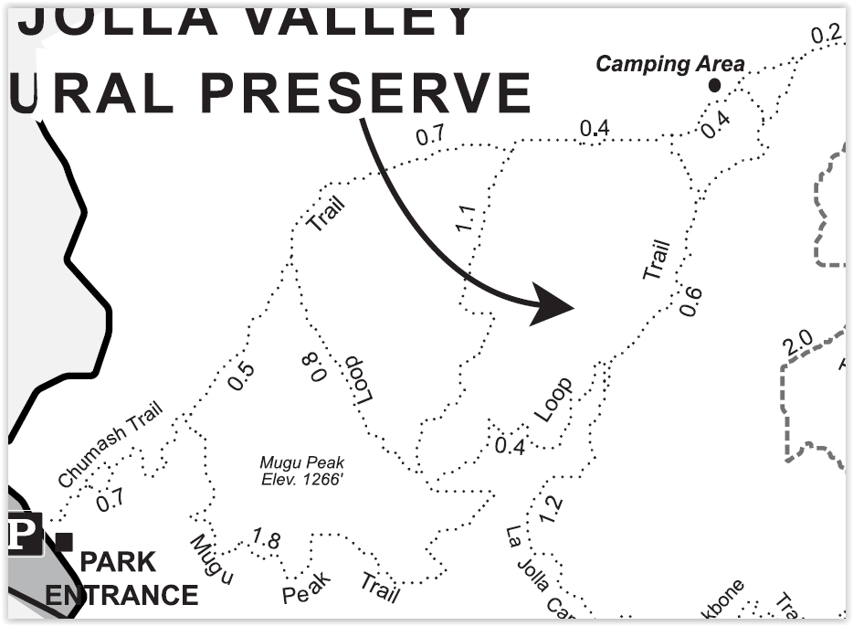
The National Park Service Visitor Center, located at 401 West Hillcrest Drive in Thousand Oaks, is an outstanding place to learn more about the Santa Monica Mountains National Recreation Area (SSMNRA). SSMNRA is over 154,000 square acres, which makes it the largest urban national park in the United States.

The National Park Service controls 21,500 of those acres and the best place to learn more about the SMM is this Visitor Center! There is always has someone on duty to answer questions about trails, maps, habitat, plants, hiking, camping, etc. Additionally, the Center has informational displays, maps and brochures, books and educational items for the kids for sale.

Visit the NPS website at www.nps.gov/samo for more information or call the Center at 805.370.2301.

Mugu Peak in Point Mugu State Park

The 1,266 foot elevation Mugu Peak is at the western edge of the Santa Monica Mountains, in Point Mugu State Park. The peak provides views stretching from the Malibu Lagoon/Naval Base Ventura County and Channel Islands on the west, Thornhill Broome Beach on the east, La Jolla Valley on the north and more.

There are multiple ways of getting to the peak. The most direct (and albeit steepest) ascent is via the Chumash Trail, accessible across from the Naval Base shooting range (yes, sometimes you will hear rounds). The Chumash Trail is accessible off of PCH at this link. Look for the left turn into a small dirt parking area that has space for perhaps 15 or so cars.

The 7/10ths of a mile hike up the Chumash Trail is pretty brutal, but I've seen all shapes, sizes and ages making it up at varying paces.

Turn left after reaching the top of the Chumash Trail. Veering left continues the Chumash Trail towards La Jolla Valley. Veer right up the really steep hill for the most direct route to Mugu Peak.

Turn left after reaching the top of the Chumash Trail. Veering left continues the Chumash Trail towards La Jolla Valley. Veer right up the really steep hill for the most direct route to Mugu Peak.

The initial Mugu Peak Trail section is quite steep, then you plateau, then the remainder is more moderate, seen above.

The initial Mugu Peak Trail section is quite steep, then you plateau, then the remainder is more moderate, seen above.

The Mugu Lagoon within Naval Base Ventura County is a colorful sight from throughout the hike and at the top of Mugu Peak.

The Mugu Lagoon within Naval Base Ventura County is a colorful sight from throughout the hike and at the top of Mugu Peak.

Looking northwest from Mugu Peak you will see the the 1,421 foot Laguna Peak, which contains a Naval satellite tracking station.

Looking northwest from Mugu Peak you will see the the 1,421 foot Laguna Peak, which contains a Naval satellite tracking station.

Views southeast with Thornhill Broome Beach in the background.

Views southeast with Thornhill Broome Beach in the background.

So you've reached the top of Mugu Peak, enjoyed the panoramic views, saluted the flag on display, checked out the toolbox under the flag with logbooks and other items, the next choice is, do you go back the way you came or do you take another route? If you head back the direction you came, the title mileage of the hike is about 2 1/2 miles of mostly steep up/downhills.

Well, if you continue in the direction of Thornhill Broome Beach (southeast), you can continue on the Mugu Peak Trail, which is several miles traversing around the southern, then western sections of Mugu Peak. This is my preferred approach as the footing is much easier and your total mileage is roughly 4 miles. Plus, you are treated to additional views that are just beautiful.

Map snippet courtesy of California State Parks.

Map snippet courtesy of California State Parks.

Another view of Thornhill Broome Beach and the large sand dune across PCH from the southeastern edge of the Mugu Peak Trail.

Another view of Thornhill Broome Beach and the large sand dune across PCH from the southeastern edge of the Mugu Peak Trail.

You can also get to Mugu Peak from the La Jolla Canyon Loop Trail.

Westlake Lake in Westlake Village

Westlake Lake is a 125 acre lake with 8 miles of shoreline in Westlake Village. Over 1,300 homes are located on the lake or are within access of it. It is a man-made lake that was completed in 1969 at a cost of $3.5 million.  A number of homes are located on an island in the lake that is connected by La Venta Drive.

View of Westlake Lake from southwest side on Triunfo Canyon Road. The Landing is on the left side.

View of Westlake Lake from southwest side on Triunfo Canyon Road. The Landing is on the left side.

While Westlake Lake is a private lake maintained for Westlake Village residents by the Westlake Lake Management Association, you can still enjoy its beauty in many ways. Running, cycling and walking around the lake via Triunfo Canyon and other adjacent streets is quite popular. Or visit The Landing (32129 Lindero Canyon) on the southwest side of the lake to enjoy a meal at one of several lakefront restaurants such as Boccacio's, Zin Bistro Americana and The Landing Grill and Sushi Bar, all with indoor/outdoor dining. Or just stroll around, taking in the sweeping views and serenity.

View from the southwest side of the Lake while cycling on Lindero Canyon Road.

The lake is stocked with bass but fishing and boating is restricted to Westlake Village residents with guests and permits. So if you don't live there, start making some Westlake Village friends!

Oak Creek Canyon Loop Trail in Thousand Oaks

The Oak Creek Canyon Loop Trail is about a mile hike that is great to do with the kids near the Los Robles Trail in Thousand Oaks.

Get there by taking Moorpark Road south of the 101 until it ends at Greenmeadow Avenue. Turn right and drive about half a mile to the parking lot.

Signs along the Oak Creek Canyon Whole Access Interpretative Trail are in braille.

Signs along the Oak Creek Canyon Whole Access Interpretative Trail are in braille.

The first .4 mile section of trail is called the Oak Creek Canyon Whole Access Interpretive Trail and is a mostly shaded oak grove area that is accessible by all, including equestrians, bicycles, hikers, wheelchairs, disabled and blind individuals. There is actually a "guide cable" along the fence as well as informational signs in braille.

One of three picnic benches along the Interpretive Trail.

One of three picnic benches along the Interpretive Trail.

There is a restroom, drinking fountain and picnic bench at the trailhead as well as two other picnic tables and a bench on this portion of the trail. There is also abundant poison oak on the sides of the trails, so be careful to stay on the trail.

OakCreekTrail3

At the end of the Interpretive Trail section of the loop, you reach a well maintained dirt trail through the chaparral that is a bit more challenging and ok for most kids. There's a few moderate hills to be aware of, making it somewhat of a challenge with a stroller but in my opinion, a do-able challenge. And of course, you can always turn around and take the Interpretive Trail back. 

The loop trail continues on the left.

The loop trail continues on the left.

One of the moderate hills on the trail.

One of the moderate hills on the trail.

You go about .4 mile back towards Greenmeadow. Before you get to the street you will see a bench on the west side of the trail. Do be aware that there is no sidewalk on this section of Greenmeadow as you walk back towards the parking area. More information and a map available on the Conejo Open Space Foundation website at www.cosf.org/website/html/oak-creek-canyon.html.

Rincon Beach Park at the Ventura/Santa Barbara County Line

RinconPark.JPG

Rincon Beach Park is near the Ventura/Santa Barbara County line just a few miles east of Carpinteria. Just take the Bates Road offramp off the 101 Freeway (or type in Bates Road and Rincon Point Road, Carpinteria). Take Bates to the ocean and on the right you'll find plenty of free parking and easy beach access, with picnic tables and restrooms.

If you make a left turn off of Bates, there's a separate parking lot for Rincon Point, part of Carpinteria State Beach, one of the most popular surf destinations in the world. There are a couple of restrooms on this side also, albeit not particularly pleasant ones to use.

Campfires are not allowed on the beach.

To learn more about Rincon Beach Park or to reserve the picnic table, visit www.countyofsb.org/842/Rincon-Beach-Park or call 805.568.2465.

Views from the picnic area at Rincon Beach Park

Views from the picnic area at Rincon Beach Park

This sign always makes for great conversation starters at Rincon Beach Park

This sign always makes for great conversation starters at Rincon Beach Park

Westward Beach In Malibu

Westward Beach is about a mile strip of beach in Malibu, sandwiched between Zuma Beach and Zuma Lagoon on the northwest and Point Dume State Beach on the east.

This nice beach has both parallel street parking available on Westward Beach Road and a paid parking lot (which on a Sunday can cost $14; weekdays are less).

What I also like about Westward Beach is its close proximity to the Point Dume Natural Preserve, and the periodic sightings of seals, dolphins and other sea life.

Westward Beach generally is not as swim-friendly as nearby Zuma Beach as the waves are choppier and less duration and higher impact. While we've taken the boogie boards into the ocean here, we weren't particularly successful at catching waves here. That said...my little ones love playing in the sand and running from the waves here.

Another cool thing at the southwest end of the beach is a sheer cliff used for rock climbing.

There are restrooms available here as well as an outdoor shower facility.

Location/Directions: Take Kanan south to PCH and turn right. Westward Beach Road is over the rise, at the foot of the hill. Call 310.457.8143 or visit www.parks.ca.gov/?page_id=623 for more information.

Alice Keck Park Memorial Gardens in Santa Barbara

Keck1.JPG

Located at 1500 Santa Barbara Street, adjacent to Alameda Park, Alice Keck Park Memorial Gardens is a beautiful botanic garden with over 75 tree and plant species. There's also a large koi pond with ducks and turtles floating around, picnic area, gazebo and walking paths. 

Formerly at this spot was the El Mirasol Hotel, which was purchased and donated to the city in 1975. An anonymous donor provided the funds to acquire the property, which was later was revealed to be Alice Keck Park (after she passed away), daughter of William Myron Keck, the founder of Superior Oil Company (now part of ExxonMobil).

Visit the City of Santa Barbara website at www.santabarbaraca.gov/gov/depts/parksrec/parks/features/horticulture/alicekeck.asp or call 805.564.5418 to make reservations.

Keck2.JPG
Keck4.JPG
Keck5.JPG

Mission Historical Park and A.C. Postel Garden in Santa Barbara

Directly across the street from the Old Santa Barbara Mission is the 8 acre Mission Historical Park (at the corner of Los Olivos and Laguna Street). The centerpiece of this park is the A.C. Postel Mission Rose Garden which has a stunning All American Rose Garden with over 1,500 rose plants. It is appealing to both your sense of sight and sense of smell.

MissionParkPic1.JPG
MissionParkPic2.JPG
MissionParkPic3.jpg
MissionParkPic4.JPG
MissionParkPic6.jpg

Rocky Peak Park in Simi Valley

RockyPeakPark_trailhead.JPG

The 4,800 acre Rocky Peak Park is located in the Santa Susana Mountains, adjacent to the 118 freeway between Yosemite Avenue and Rocky Peak Road in Simi Valley. It is visually stunning to see as you drive up the 118 grade east towards the San Fernando Valley.

View of Rocky Peak Park from Highway 118 driving eastbound

View of Rocky Peak Park from Highway 118 driving eastbound

There are large sandstone structures, unusually balanced rocks, caves and other interesting formations throughout Rocky Peak Park. Plenty to explore and views abound!

The main entrance to the park is the Rocky Peak Trail, which runs north/south over about five miles of fire roads. It is moderately strenuous, with lots of hard, rocky surfaces, so make sure to wear solid shoes for this trail. Be prepared for panoramic views of Simi Valley and the San Fernando Valley as the trail is nearly on the Ventura/Los Angeles County line.

To get there from the west, take the 118 east to Rocky Peak Road. The trailhead is across (north of) the freeway, but parking is very limited, so plan to park on Santa Susana Pass Road, where plenty of street parking is available - just turn right at the end of the offramp and you’re there.

Lots of rocky surfaces on the Rocky Peak Trail as you can see

Lots of rocky surfaces on the Rocky Peak Trail as you can see

Trails that intersect the Rocky Peak Trail going east/west include the Hummingbird Creek Trail, Chumash Trail and Las Llajas Canyon Trail. Not far into Rocky Peak Trail you'll see a sign that indicates the Hummingbird Creek Trail.

No doubt about it...you'll have some really nice views of Simi Valley from up here!

No doubt about it...you'll have some really nice views of Simi Valley from up here!

After reaching the 2,715 foot Rocky Peak and taking in the views, if you're up to it you can continue north where you will pass by the Chumash Trail and Las Llajas Canyon Trail.

The Rocky Peak Trail terminates north of Blind Canyon in Las Llajas Canyon. You must then double back to return to the trailhead, or take the three mile Chumash Trail down to the westernmost boundary of the property at the end of Flanagan Drive in Simi Valley.

Chumash Trail is about 3 miles of steady climb from Flanagan Drive. To get to the Chumash Trail trailhead, take the 118 to Yosemite, go north, turn right on Flanagan to the end. Park on the street.

The Hummingbird Trail was built by the Rancho Simi Recreation and Park District, starting near Kuehner Drive and the 118 Freeway. The trail leads up to the main Rocky Peak Trail. During and just after the rainy season, the trail passes cascades flowing down the sandstone boulders and cliffs. It is about 2 miles or so each way. Take the 118 to Kuehner, go north to the parking area about a quarter of a mile away.

Clearly marked sign on Rocky Peak Trail showing the Hummingbird Trail turnoff

Clearly marked sign on Rocky Peak Trail showing the Hummingbird Trail turnoff

Rocky Peak Park is maintained by the Santa Monica Mountains Conservancy. Learn more at mrca.ca.gov/parks/park-listing/rocky-peak-park. Dogs are allowed on these trails on leash.

Peering down upon the northwest San Fernando Valley from Rocky Peak.

Peering down upon the northwest San Fernando Valley from Rocky Peak.

Point Mugu State Park

Point Mugu State Park is located in the Santa Monica Mountains, stretching from Newbury Park on the north to five miles of ocean shoreline on the south. The park includes 14,000 acres of land with over 70 miles of trails popular with hikers, cyclists and runners.  It is truly an amazing place, with rocky peaks that include the prominent Boney Mountain State Wilderness that looks over the western Conejo Valley.

The sign in Rancho Sierra Vista/Satwiwa in Newbury Park indicating you are entering State-managed Point Mugu State Park.

The sign in Rancho Sierra Vista/Satwiwa in Newbury Park indicating you are entering State-managed Point Mugu State Park.

You can actually hike, run or bike from Newbury Park, from the Rancho Sierra Vista/Satwiwa area managed by the National Park Service down to the ocean via Sycamore Canyon "Sycamore to the Sea," which is about an 8 mile trip one way. But do be aware - the initial 800 foot drop from Rancho Sierra Vista into the canyon via Big Sycamore Canyon Road is a bit more challenging coming back up.

The paved hill drops into the canyon via Sycamore Canyon Fire Road.

The paved hill drops into the canyon via Sycamore Canyon Fire Road.

There are four main canyons in Point Mugu State Park. Sycamore Canyon is perhaps the most well known, stretching practically the entire north/south length of the park, where at the bottom of the canyon you'll find the 58 space Sycamore Canyon Campground at 9000 W. Pacific Coast Highway (make reservations at ReserveCalifornia.com and search for “Point Mugu SP”).

The Sycamore Canyon Campground connects to the Sycamore Canyon Fire Road, which is your access point to a day of fun and adventure in Point Mugu State Park trails.

The Sycamore Canyon Campground connects to the Sycamore Canyon Fire Road, which is your access point to a day of fun and adventure in Point Mugu State Park trails.

The La Jolla Valley Natural Preserve is on the western side of the park, with a main access point near Thornhill Broome State Beach at the Ray Miller Trailhead to the La Jolla Canyon Trail which connects with the Loop Trail. Another access point to La Jolla Valley is the Chumash Trail trailhead, a rocky, steep trail across from Point Mugu Beach. La Jolla Valley was purchased by the State of California in 1966 and was established as a Natural Preserve in 1972.

Wood Canyon is in the northwest section of the park, where you will find the north/south running Wood Canyon Fire Road, which connects to the Guadalasca Trail, among others.

Serrano Valley is accessible from the south off the Big Sycamore Canyon Fire Road/Trail about a mile north of the beach. A beautiful, serene, area, with a connection to the Old Boney Trail that takes you to the Danielson Monument in the Boney Mountain Wilderness.

The main beach areas in Point Mugu State Park, running southeast to northwest, are Sycamore Cove, Thornhill Broome and Point Mugu. Sycamore Cove is a fun day-use park popular with families for gatherings with BBQ grills and picnic tables. Learn more about beaches in the Malibu area at this link.

This is the PCH overpass where on low tide you can walk underneath here to get from Sycamore Cove Beach to Sycamore Canyon Campgrounds and hiking in Point Mugu State Park. In higher tides, this area can be dicey, so be careful.

This is the PCH overpass where on low tide you can walk underneath here to get from Sycamore Cove Beach to Sycamore Canyon Campgrounds and hiking in Point Mugu State Park. In higher tides, this area can be dicey, so be careful.

If you are looking for beachfront camping, try Thornhill Broome Beach, with just over 60 spots available for RVs and tents. No hookups here and only porta-johns available, but can't beat the views! And across the street you can't miss the Giant Sand Dune!

Day use parking at the various sites is available for $12. There is very minimal street parking at Sycamore Cove but plenty of street parking adjacent to Thornhill Broome Beach.

Dogs on a leash are allowed in the Park's day use areas, campgrounds and beaches. Dogs are not allowed on the back country trails or dirt roads.

Keep driving northwest on PCH and you'll past the famous Mugu Rock and see Pt. Mugu Beach, which also has day use parking, with some parking on PCH. Learn more at the California State Parks website at www.parks.ca.gov/?page_id=630.

Mugu Rock up ahead, driving north on PCH from Thornhill Broome.

Mugu Rock up ahead, driving north on PCH from Thornhill Broome.

Lastly, let's cover some of the highest peaks in Point Mugu State Park. The Boney Mountain Wilderness Area, ever so prominent from the Conejo Valley, is located in the Park. But Boney Peak itself, at 2828 feet, is actually in the Circle X Ranch area managed by the National Park Service, along with Sandstone Peak, the highest spot in the Santa Monica Mountains at 3111 feet.

Boney Mountain range overlooks the western Conejo Valley.

Boney Mountain range overlooks the western Conejo Valley.

Other peaks include Tri Peaks at 3010 feet, Laguna Peak (the peak which has equipment from Naval Base Ventura County below), La Jolla Peak and Mugu Peak

Map of Point Mugu State Park courtesy of National Park Service.

Map of Point Mugu State Park courtesy of National Park Service.

Hiking in the North Ranch Open Space in Thousand Oaks

The North Ranch Open Space is represented by several massive sections of nearly 2,600 acres located in the east side of Thousand Oaks. There is a section east of Erbes Road to Westlake Boulevard down to Hillcrest Drive on the west side (this area is referred to as the Hillcrest Open Space Preserve) as well as a section further east bounded by Westlake Boulevard on the west, Lindero Canyon Road on the east and Thousand Oaks Boulevard on south.

These hills are beautiful and quite prominent from throughout the Conejo Valley. Hiking, running and cycling these hills can be a challenge as they are quite steep in most sections.

A main trailhead into the North Ranch Open Space is on Bowfield Street, just east of the North Ranch Playfields. The trail is called the Saddle Pass Trail, winding up and down the hills south towards Thousand Oaks Boulevard.

There are various other neighborhood trail entry points throughout the vast area. One of these is located at Canyon Oaks Park, 6200 Hedgewall Drive, Westlake Village. There's a walkway and a small bridge that leads to a quite intense looking path up the hill. And indeed, it is a very steep path. Definitely not for everyone. This is a path into the Bowfield/Saddle Pass Trail, which is maintained by the Conejo Open Space Conservation Agency.

The Wishbone Trail is a loop trail into the North Ranch Open Space that starts and ends at Westlake Village Community Park, 31107 E. Thousand Oaks Blvd., Westlake Village. Trailhead is at the west end of the parking lot. You can connect to the Saddle Pass Trail from the Wishbone Trail via the Wishbone Connector trail.

Small COSCA sign at the bottom of the steep hill from Canyon Oaks Park leading into the North Ranch Open Space.

Small COSCA sign at the bottom of the steep hill from Canyon Oaks Park leading into the North Ranch Open Space.

A view of Canyon Oaks Park from about a third of the way up the hill.

A view of Canyon Oaks Park from about a third of the way up the hill.

There are roughly 3 or 4 miles of trails up here, mostly the Saddle Pass north/south trail but other connector trails to nearby neighborhoods, such as the townhome complex on Via Colinas above Thousand Oaks Blvd and the new Westlake Village Community Park and YMCA.

These hills get quite dry and hot during the summer months but in the spring green up nicely. You may even get the opportunity to enjoy some wildflowers.

Orange beauties can often be seen in the March time frame off the Saddle Pass Trail south section.

Orange beauties can often be seen in the March time frame off the Saddle Pass Trail south section.

Here's another section of trail that connects homes off of Via Colinas into the North Ranch Open Space. Most of these connector trails are quite steep, though generally well maintained!

Here's another section of trail that connects homes off of Via Colinas into the North Ranch Open Space. Most of these connector trails are quite steep, though generally well maintained!

California poppies on March 16, 2019.

California poppies on March 16, 2019.

Los Angeles Zoo and Botanical Gardens

LAZoo_logo.png

The 133 acre Los Angeles Zoo and Botanical Gardens first opened in 1966. The Zoo is home to more than 2,200 mammals, birds, amphibians and reptiles representing more than 270 different species of which more than 58 are endangered. In addition, the Zoo’s botanical collection comprises several planted gardens and over 800 different plant species with over 7,400 individual plants. The Zoo receives over 1.8 million visitors per year and is owned and operated by the City of Los Angeles.

There's a children's zoo area with a petting zoo and fun exhibits. There's also a play area for kids that is quite popular.

Some advice! The line to get into the park can get pretty long on weekends. My advice is to buy an L.A. Zoo Membership! There is a $150 one-year family membership (as of January 2022) that gives you FREE admission for 2 adults and all of your kids or grandkids ages 2-17.  If you have a family of 4 and visit the park twice a year, this membership SAVES YOU MONEY as the regular entry cost is $22 for adults and $17 for ages 2 to 17. Ages 62+ is $19. (Pricing as of January 2022.) Plus, there was NO LINE to get in with your membership card! That alone gave us an extra 30 minutes in the park today. 

Zoo membership also gives you free or discounted admission to zoos and aquariums across the country, including 50% off at the Santa Barbara Zoo!

The Living Amphibians, Invertebrates, Reptiles (LAIR) exhibit opened in March 2012. There is a damp forest section that has Fiji Island banded iguanas, poison dart frogs, Guatemalan palm vipers and Fly River turtles, an area where you can watch staff taking care of the animals, tortoises, lizards, crocodile swamp, desert reptiles and much more. We also learned that Mexico has more reptile species than any other country on earth.

The L.A. Zoo is located at 5333 Zoo Drive, Los Angeles. Visit www.lazoo.org for more information.

LAZoo_sign.jpg
Hippo relaxing at the Los Angeles Zoo

Hippo relaxing at the Los Angeles Zoo

Nicely appointed kids' play area at Los Angeles Zoo

Nicely appointed kids' play area at Los Angeles Zoo

Rhino at Los Angeles Zoo is just kickin' it

Rhino at Los Angeles Zoo is just kickin' it

Zebra at Los Angeles Zoo is having a snack

Zebra at Los Angeles Zoo is having a snack

Lair2.JPG

Rabbit Hill (Knoll Open Space) in Newbury Park

KnollTrail1.JPG

The Knoll Open Space is a 21 acre plot of land owned by the Conejo Open Space Conservation Agency located at the corner of Reino Road and Old Conejo Road in Newbury Park (across the street from Peppertree Playfields). This plot of land is more affectionately known as Rabbit Hill. While it doesn't take too much effort to get to the top of Rabbit Hill, you will definitely be rewarded with a nice, panoramic view towards Boney Mountain, Thousand Oaks and Conejo Mountain. This hill is somewhat less challenging than the steeper Tarantula Hill in Thousand Oaks, so if you're looking for a nice after-dinner stroll, this is a fine choice. While not the most exciting hill to look at, the views make it worthwhile! You can park on Reino Road to start your short journey.

You can either take a straight shot up the hill or a more gradual curved trail. 

You can either take a straight shot up the hill or a more gradual curved trail. 

Views toward Boney Mountain.

Views toward Boney Mountain.

Views towards Thousand Oaks