Identify Local Sex Offenders Using California Megan's Law Website

MegansLaw.jpg

California was the first state in the nation to initiate a Sex Offender Tracking Program in 1947, but until 1996, when California Megan's Law (CML) was initiated, information about sex offenders was not publicly available. 

Megan's Law is named after seven year old New Jersey girl Megan Kanka, who was raped and killed by a known molester who lived across the street from her family. All states now have a form of Megan's Law. On September 24, 2004, AB 488 was signed into law in California, providing the public Internet access to sex offender information at www.meganslaw.ca.gov.

This is a website that deserves a look, particularly by anyone who is a parent. While the website is not meant to "punish" sex offenders, it is a useful awareness tool. The search engine on the site allows you to search by name, address, city, zip and county, as well as within a two mile radius of parks and schools. You can also review the results of your search in both map and listing format.

Within seconds you can identify the 880=1 (as of July 2024) registered sex offenders in Ventura County, including photos, names, vital stats like date of birth, height and weight, their offenses and, where applicable, their addresses. You can view the offenders on a map or on a list.

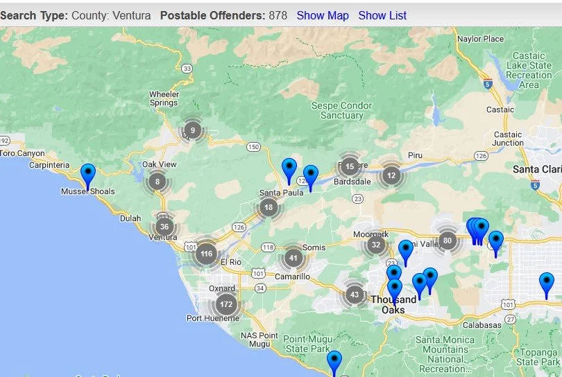
Map view of megan’s Law offenders in Ventura County as of January 2023

The information in the CML database is not always up to date for each individual. The severity of the offenses for each individual vary from the more violent (rape, battery) to statutory rape, indecent exposure, etc.

Formula (Chain) Business Ordinance Since 2007 in Ojai

Since December 2007, the City of Ojai has had what’s called a Formula Business ordinance which bans new retail establishments that have over a designated number of locations with similar features such as standard menus, merchandise, decor, signage, facade, etc. Basically it’s ban of large chains (e.g. Starbucks, McDonald’s, 7-Eleven, etc.) to ensure the city maintains its small town charm.

Initially the ordinance defined a Formula Business as over 10 locations; it has since been changed to five or more locations. For more information, review City of Ojai municipal code section 10-2.1713.

This ordinance covers the 4.37 square mile City of Ojai. It does not cover other communities in the greater Ojai Valley.

Mira Monte (Spanish for “mountain view”) is an unincorporated community of approximately 6,800 residents in Ventura County that is located southwest of Ojai. Since Mira Monte does not have its own post office, addresses in this community use Ojai.

Several CVG social media followers brought up this interesting point because there are some chain establishments located in Mira Monte that have an Ojai address, such as the new drive-in Habit Burger (opened July 17, 2024), Starbucks, McDonald’s, and Taco Bell. Although these chain establishments have an Ojai address, they are not subject to the City of Ojai Formula Business ordinance. And there ya have it.

Evolution of the Conejo Grade in Ventura County Over the Last 100 Years

Horseshoe shaped section of the Conejo Grade in the 1920s.

Horseshoe shaped section of the Conejo Grade in the 1920s.

The Conejo Grade is the section of Highway 101 that connects the Conejo Valley with Camarillo. It is a four mile stretch of freeway with a significant 7% grade.

Going down the Conejo Grade from Newbury Park to Camarillo today.

Going down the Conejo Grade from Newbury Park to Camarillo today.

At 3:30 p.m. on the afternoon of May 1, 1937, a newly upgraded and realigned Conejo Grade premiered after a day of celebration commencing at the ranch of Adolfo Camarillo. Camarillo, the namesake of what in 1964 became the City of Camarillo, donated the right of way to enable the grade to be realigned. Actor Leo Carrillo entertained guests at Camarillo's ranch at the bottom of the grade.

Grand opening of the newly realigned Conejo Grade on May 1, 1937.

Grand opening of the newly realigned Conejo Grade on May 1, 1937.

The old Conejo Grade was constructed by the California Highway Commission in 1914-1915. The previous route had 49 twists and turns, making it somewhat hazardous to drive (albeit somewhat less steep than the current grade). The newly aligned Conejo Grade cut the number of curves by 75%.

Another view of the Conejo Grade before it was realigned in 1937.

Another view of the Conejo Grade before it was realigned in 1937.

The new 1937 Conejo Grade cost a total of $570,000, which is less than the average cost of a house in the Conejo Valley today! Over a year and a half, the project employed about 100 workers who put in over 272,000 hours, excavating over 800,000 cubic yards of mostly hard rock. Talk about rock stars!

In the 1950s and 1960s, Caltrans further widened and improved Highway 101 over the Conejo Grade.

In the 1950s and 1960s, Caltrans further widened and improved Highway 101 over the Conejo Grade.

Several decades later, as Ventura County grew and the cities of Camarillo and Thousand Oaks incorporated in 1964, Caltrans continued to widen and improve the highway to what it is today.

ConejoGrade2014_2.jpg

Source for historical information: "California Highways and Public Works" (May 1937) - official journal of the State of California Division of Highways, Department of Public Works.

Special thanks to the Pleasant Valley Historical Society for providing historic photos.

Then and Now: The Dairy Farm at Camarillo State Hospital

In 1932, the State of California purchased 1,760 acres of the Lewis Ranch and built the Camarillo State Mental Hospital, which operated from 1936 to 1997 and at one point treated as many as 7,000 patients in the mid 1950s.

Located on the parcel was a dairy farm that produced crops and housed livestock that fed the hospital community. The farm was disbanded in the 1960s and has been left in a state of disrepair, falling prey over the decades to vandals and coined "Scary Dairy."

Here are some "then and now" photos of the most prominent elements of the dairy farm.

The hay barn at Camarillo State Hospital in the 1940s (CSUCI John Spoor Broome Library historic photo collection)

The hay barn at Camarillo State Hospital in the 1940s (CSUCI John Spoor Broome Library historic photo collection)

The hay barn today.

The hay barn today.

The dairy at Camarillo State Hospital in the mid-1950s. (CSUCI John Spoor Broome Library historic photo collection)

The dairy at Camarillo State Hospital in the mid-1950s. (CSUCI John Spoor Broome Library historic photo collection)

The dairy building today, fenced off, covered with graffiti. 

The dairy building today, fenced off, covered with graffiti. 

Inside the hay barn - undated photo. (CSUCI John Spoor Broome Library historic photo collection)

Inside the hay barn - undated photo. (CSUCI John Spoor Broome Library historic photo collection)

Inside of hay barn - more recently.

Inside of hay barn - more recently.

Get or Give Free Stuff With Freecycle

freecycle_logo.jpg

The Freecycle Network has over 5,300 groups and 11.3 million members around the world.  It is a grassroots, nonprofit movement of people who are giving (and getting) stuff for free in their own towns and thus keeping it out of landfills.  Membership is free, and everything posted must be free, legal and appropriate for all ages.

More information is available at www.freecycle.org.  There are groups organized and moderated by volunteers in many different locations via use of Yahoo Groups.

Here are the Ventura County area groups as of July 2024:

Thousand Oaks Group (2,600 members)

Simi Valley Group (1,700 members)

Ventura Group (2,100 members)

So check it out!  Somebody may need something that you don't want!

Another source for giving and getting local free stuff is www.craigslist.com.  Here is a link to free stuff in the Ventura County Craiglist and Los Angeles County Craigslist.

Satellite Tracking Station at Laguna Peak for the Naval Satellite Operations Center Point Mugu (Now 10th Space Operations Squadron)

UPDATE: On June 6, 2022, the Naval Satellite Operations Center that previously was responsible for the Laguna Peak station was transferred from the Navy to the Space Force, specifically, the 10th Space Operations Squadron (10 SOPS). The mission of 10 SOPS, which is headquarted at Naval Base Ventura County, is to operate, manage, and maintain assigned satellites and ground systems, providing continuous and reliable satellite communications in direct support of Fleet, Joint, and Interagency operations. Learn more at THIS LINK and about 10 SOPS at www.petersonschriever.spaceforce.mil/About-Us/Fact-Sheets/Display/Article/3146952/10th-space-operations-squadron.

(Military photo of Laguna Peak.)

(Military photo of Laguna Peak.)

If you’re in the vicinity of Thornhill Broome State Beach and Sycamore Cove Beach in Point Mugu or hiking up the Chumash Trail to the La Jolla Valley in Point Mugu State Park, you’ve probably noticed some futuristic looking equipment up on a hill to the west.

That hilltop is the 1,421 foot Laguna Peak in the westernmost tip of the Santa Monica Mountains, home to the Naval Base Ventura County’s Satellite Tracking Station.

The tracking station monitors rocket launches from Vandenberg Air Force Base and other sites and is a part of a network of satellite control facilities that includes stations in Prospect Harbor, Maine, Rosemount, Minnesota and the Lincoln Laboratory in Massachusetts.

laguna peak from PCH.JPG

Hiking to the Waterfall in Pt Mugu State Park from Rancho Sierra Vista/Satwiwa

One of the most popular hikes in the Rancho Sierra Vista/Satwiwa open space in Newbury Park is to a small waterfall in the adjacent Boney Mountain Wilderness. The hike is about 3 1/2 miles round-trip from the Satwiwa Native American Indian Culture Center and is a moderate hike that can be done by all ages.

Keep in mind that in drought years, there’s sometimes not more than a trickle flowing down this waterfall, while in rainier years like 2023-2024, the waterfall is quite active. In either case, it’s a fun hike to do.

You have two primary options for where to start the hike. You can drive into the Rancho Sierra Vista park entrance on Via Goleta in Newbury Park and park in a lot that is a brief walk to the Culture Center, or you can park at the Wendy Drive and Potrero Road trailhead and add an another two miles, round trip, to your adventure.

The entrance to Rancho Sierra Vista/Satwiwa at Via Goleta, 1 mile west of Reino Road.

The entrance to Rancho Sierra Vista/Satwiwa at Via Goleta, 1 mile west of Reino Road.

The trailhead where Wendy Road ends at Potrero Road in Newbury Park

The trailhead where Wendy Road ends at Potrero Road in Newbury Park

The Satwiwa Native American Indian Culture Center is a small building open from 9am to 5pm on weekends where you can learn about native Chumash items and local wildlife.

The Satwiwa Native American Indian Culture Center is a small building open from 9am to 4pm on weekends (as of April 2024) where you can learn about native Chumash items and local wildlife.

Next to the Culture Center, you'll see multiple paths, all of which can get you to your destination, but the most direct path is the Satwiwa Loop Trail seen on the left, which crosses through a meadow that can be quite green and beautiful in late Winter/early Spring and dry and brown the rest of the year. An alternate route is on the right of the picture above - the Big Sycamore Canyon Trail (paved road) to the Boney Mountain Trail, where you'll take a left.

Satwiwa Loop Trail section that takes you diagonally through the meadow. Seen here when it is nice an green.

Satwiwa Loop Trail section that takes you diagonally through the meadow. Seen here when it is nice and green.

At the end of the meadow, continue straight up a fairly steep hill, where on the right hand side you'll see the Sycamore Canyon Overlook bench shown below.

RSVW_sycoverlook.JPG

bench on sycamore canyon overlook

Hike up the moderately steep and rocky path up the hill behind the bench and you'll reach another fork in the road. If you veer left at this juncture you'll be on the Hidden Valley Overlook Trail within Rancho Sierra Vista/Satwiwa. Stay to the right and you'll be entering the Boney Mountain Wilderness area within Point Mugu State Park.

Sign that shows you the Hidden Valley Overlook Trail is on the left.

Sign that shows you the Hidden Valley Overlook Trail is on the left.

Veering right into the State of California managed Pt Mugu State Park; as you can see, dogs are not allowed in the back country area of the park.

Veering right into the State of California managed Pt Mugu State Park; as you can see, dogs are not allowed in the back country area of the park.

This trail is referred to as Danielson Road, named after the last private owner of these lands. The path down into the canyon is seen below (taken from a higher point en route to the Danielson Monument).

View of the initial section of Danielson Road trail down into the canyon; this is the path you will be taking towards the waterfall.

View of the initial section of Danielson Road trail down into the canyon; this is the path you will be taking towards the waterfall.

Danielson Road is a bit on the steep side but I see folks young and old walking up and down this section all the time. Seen here in very dry conditions.

Danielson Road is a bit on the steep side but I see folks young and old walking up and down this section all the time. Seen here in very dry conditions.

RSVW_waterfalltrailsign.JPG

THIS IS THE OLD SIGN, WHEN IT WAS CALLED DANIELSON ROAD (PRIOR TO 2024)

NEW SIGN IN 2024 SHOWING THE “OLD CABIN TRAIL” INSTEAD OF DANIELSON ROAD.

After .4 mile, you will reach the bottom of the canyon and see the sign above, the final sign indicating you are on your way to the Waterfall Trail. Then you will cross a creek bed, which can have water in it after the rains. The photo taken below in January 2015 shows minimal moisture, making it easy to cross. Some years you may have to rock hop your way a bit over the creek.

RSVW_stream.JPG

Creek bed crossing on the way to the waterfall IN 2015

Creek Crossing in April 2024.

After you cross the creek, the remainder of the trail to the waterfall is single track. Be careful not to come in contact with poison oak often seen on the sides of the trails. For this reason, I would generally not recommend strollers be taken up here.

Soon you will reach the final fork in the road. Go straight and soon you will be at the waterfall. To the right, the Old Cabin Trail (formerly Danielson Road Trail) continues upward to the Danielson Monument.

RSVWaterfallFeb17.JPG

the waterfall in april 2024.