City of Fillmore Neon-Lighted Sign From Pre-World War II
/You don't see many signs around town like the Fillmore sign at the northeast corner of Highway 126 (E. Telegraph Road) and Central Avenue.

Fillmore sign photo taken as I was waiting at the stoplight driving south on Central Avenue.
The sign was originally constructed in 1940, making it 80 years old. It is designated a historical landmark by the City of Fillmore.
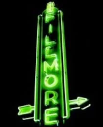
The Fillmore sign is a cool green neon lit up at night
It's not exactly easy getting to Fillmore from the Conejo Valley as you either have to take the winding path of the 23/Grimes Canyon Road via Moorpark or drive out to Ventura via the 101 and take the 126 to Fillmore by way of Santa Paula. Kind of a haul but certainly fun to do every now and then.
At a total area of only 2.8 square miles, Fillmore is the smallest of Ventura County's 10 cities, and its population of roughly 16,000 places it 9th (roughly double the population of Ojai). Fillmore was not named after Millard Fillmore; it was named after Jerome Fillmore, General Superintendent of the Southern Pacific Railroad when they built the line connecting Santa Paula, Fillmore and Castaic.
Quite a quaint little place that is certainly fun to visit, with highlights such as numerous themed train rides at Fillmore & Western Railway, State Fish Hatchery and Railroad Visitor Center, along with an old town feel along Central Avenue.

Fillmore sign as of July 2022