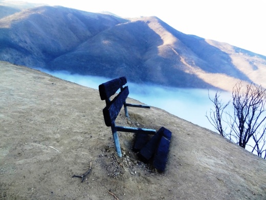
Evolution of Bench at Upper Sycamore Canyon Overlook at Rancho Sierra Vista
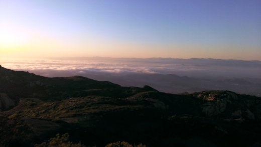
The Springs Fire started the morning of May 2nd along the 101 freeway on the Conejo Grade and burned over 28,000 acres through portions of Camarillo, Newbury Park and the Santa Monica Mountains Recreational Aea until it was fully contained the following week.

Rancho Sierra Vista/Satwiwa and other trails in Pt Mugu State Park were re-opened in mid to late May. It will take time for the vegetation to grow back and for structures that were burned to be rebuilt. One such structure is the bench overlooking Upper Sycamore Canyon. The bench was burnt severely and was rendered unusable. However, lo and behold, the bench has been replaced! Happy trails!

The healthy, new bench overlooking Upper Sycamore Canyon in September 2013

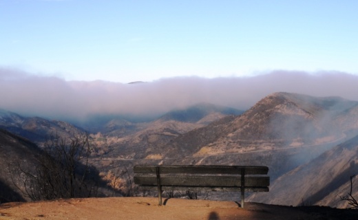
Bench overlooking Upper Sycamore Canyon in August of 2013.

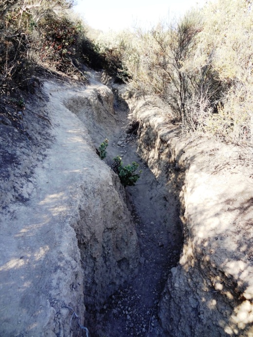
The not-so-healthy looking bench overlooking Upper Sycamore Canyon after the fire.
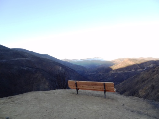
View from the new and improved bench at Upper Sycamore Canyon Overlook in Sept 2013

Bench at Upper Sycamore Canyon Overlook on May 14, 2013
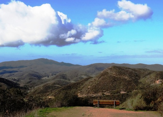
Bench at Upper Sycamore Canyon Overlook prior to Springs Fire on February 10, 2013

All sorts of benches in and around the Conejo Valley

Photos of the Pepperdine University 9/11 Waves of Flags Display From Scott Harrison

For the sixth year in a row, Pepperdine University has staged a dramatic display of flags on its expansive lawn at Alumni Park, Malibu, to honor the victims of the September 11, 2001, terrorist attacks. Each flag, reflecting each victim's nationality, represents each of the nearly 3,000 lives lost on that tragic day.

Photo Credit: Scott Harrison www.harrysonpics.comThe installation of the flags, which will be on display until Monday, Sept. 23, was conceived and led by the University's chapter of the College Republicans in 2008. Since that time, the display has come to be a focal point in the Malibu community to gather in remembrance and meditation of the innocent lives lost on 9/11, including Tom Burnett, alumnus of the Graziadio School of Business and Management.

Burnett's heroism as a passenger on United Airlines Flight 93 has been well documented. As a result of the passengers' attempt to take control of the hijacked airliner and divert it from reaching the terrorists' target, United 93 crashed in a field in Pennsylvania rather than striking a building or landmark in the nation's capital, causing more loss of human life.

As it has annually since September 2001, the Office of the Chaplain, the Department of Public Safety (DPS), and the Office of the President will host a brief memorial service at 12:15 p.m. on Wednesday, Sept. 11, at the Heroes Garden, a 14,880-square-foot outdoor sanctuary that overlooks the Pacific Ocean on one of the highest bluffs on the Malibu campus. The garden serves as a public space to pause, reflect, and honor those who sacrificed their lives on 9/11, including Burnett.

Source: Pepperdine University

Local photographer Scott Harrison has once again provided some great photos of the Pepperdine display below. See more of Scott's work at www.harrysonpics.com.

Pepperdine University's Annual Waves of Flags Display in Honor of 9/11 Victims

PeppFlags9.9.13_1.JPG

Once again this year (2013), Pepperdine University students and other volunteers staged a display of nearly 3,000 flags in honor of each of the victims of the September 11, 2001 terrorist attacks. The display was at Alumni Park, at the corner of Pacific Coast Highway and Malibu Canyon Road. Each victim is memorialized with a flag reflecting their nationality.

Whether you visit at night or during the day, this tremendous display is a sobering reminder of one of our country's darkest days.

PeppFlags9.9.13_2.JPG
PeppFlags9.9.13_0.JPG

Thousand Oaks Police Department Reminds Drivers to Slow Down

According to the Thousand Oaks Police Department, in the past 12 months there have been seven fatal traffic collisions in the City of Thousand Oaks. Four of these fatalities have occurred on Westlake Boulevard. Three of the fatalities were motorcycle riders and the one this week was a solo vehicle into a power pole. Speeding was a factor in all of the accidents. The victims were boys 21 years of age and younger.

As a result of the latest traffic collision, a 17-year-old passenger is still in critical, but stable condition. Both boys in the last accident were scheduled to start their senior year at Thousand Oaks High School this week.

The Thousand Oaks Traffic Division would like to put an end to these tragedies. Therefore, the traffic division will be increasing enforcement in this area and other areas prone to speeding in an effort to make the roadway safer.

Please take the time drive safely. Most importantly, reduce your speed and obey all traffic laws.

Source: Thousand Oaks Police Department

Speaking of speeding teens, less than two weeks ago my wife and kids were driving on Lynn Road near the 101 in the late afternoon when another local teen managed to lose control of the car he was driving and barrel across the median into oncoming traffic, totaling both cars. SLOW DOWN indeed and don't even think about texting while driving!

Experiencing the Mishe Mokwa Trail to Sandstone Peak Hike with My Kids

Sandstone1.jpg

On the President's Day holiday I took my boys to the Sandstone Peak trailhead in the Santa Monica Mountains in Malibu for the six mile Mishe Mokwa Trail to Sandstone Peak.

I've discovered that many, perhaps even most, local residents have never heard of Sandstone Peak. They know about the prominent Boney Mountain overlooking the Conejo Valley, but the highest peak in the Santa Monica Mountain range at 3,111 feet is something new!

Well Sandstone Peak is something that you must explore at some point. Not exactly for the faint of heart, this peak provides panoramic, 360 degree views stretching from the Channel Islands, Conejo Valley, San Fernando Valley and beyond.

Perhaps the biggest challenge is getting to the trailhead. While only 12 miles from the Westlake Boulevard/101 freeway juncture, it take close to 30 minutes to get there via the winding, Decker Canyon, Mulholland Road and Yerba Buena Road. The main dirt parking lot has room for perhaps 25 cars, while there are several smaller dirt lots and some street parking available.

MisheMokwaTrailhead.JPG

Once we parked, I made sure we had water and snacks packed. We started our trek around 2pm on a cool afternoon, so I also made sure to pack a second layer for us. The first section of the hike from the parking lot to the Mishe Mokwa trailhead is probably the steepest stretch of the entire hike. So of course about 27 steps into the hike my youngest (age 7) wants to stop and take a break. Uggh. But after finding some distractions on the trail, we made it to the Mishe Mokwa trailhead sign. Yippee!

View of Balanced Rock from the south.

View of Balanced Rock from the south.

The first half of the hike is mainly north/northeast facing and was almost entirely shaded. The trail is fairly moderate all the way to Split Rock, though there are a couple slightly "dicey" sections where the kids made my blood pressure go up a bit.

Within a few miles, you'll see the famous Balanced Rock (pictured above), a display that has you staring in amazement. How the heck that large rock balances on the smaller one is beyond me. And the photo (as well as this closer view from the north on Pinterest) does not do it justice.

Navigating one of the more narrow sections of the trail overlooking Balanced Rock

Navigating one of the more narrow sections of the trail overlooking Balanced Rock

Just west of Balanced Rock is a small stream and Split Rock, a large boulder with a crack in it large enough to walk through. There's also a picnic bench here, where you can relax and replenish. In the canyons between Balanced Rock and Split Rock are the Echo Cliffs...aptly named as the echo effect in that area is quite fun to explore. Many folks hike to Split Rock, enjoy a picnic, then head back. Or you can continue onward for the full 6 mile or so loop to Sandstone Peak and back.

Split Rock, about 2 miles into the hike

Split Rock, about 2 miles into the hike

MosheMikwaRockFace.JPG

The section of the Mishe Mokwa Trail between Split Rock and the Backbone Trail intersection is about 1 1/2 miles or so.

The sign telling us we are (finally) almost at the Backbone Trail, which will take us to Sandstone Peak and back to our car on Yerba Buena Road

The sign telling us we are (finally) almost at the Backbone Trail, which will take us to Sandstone Peak and back to our car on Yerba Buena Road

Views from Sandstone Peak looking north towards the Conejo Valley/Ventura County

Views from Sandstone Peak looking north towards the Conejo Valley/Ventura County

We had been heading north/northwest on the Mishe Mokwa trail and now we were heading east on the Backbone Trail. A couple times I was slightly confused by offshoot trails, but we found the way by staying on the main trails.

It's a bit of a challenge and rock climb to get to the actual top of Sandstone Peak once you reach its base (CLICK HERE for more details). And once you reach the top, looking down at the canyons below, with the kids running around, can be quite unnerving. (In fact, if your kids are really "active" you may not want to bring them to the top...kind of scary...and dangerous.) But we made it up there and survived!

Views from Sandstone Peak looking towards the Pacific Ocean

Views from Sandstone Peak looking towards the Pacific Ocean

Find out more about this and other hikes on the National Park Service Circle X Ranch website at www.nps.gov/samo/planyourvisit/circlexranch.htm, where you will find a detailed pdf map of the various hikes in that area.

SandstoneMap.jpg

Circle X area map excerpt courtesy of National Park Service. Full map with detailed information at www.nps.gov/samo/planyourvisit/circlexranch.htm.

Views From Boney Peak on an Overcast August Morning in the Conejo Valley

The cloud cover has since burned off but this morning it formed a layer over the Conejo Valley that made for surreal views from above on Boney Mountain.

Click this image for a full size version on Pinterest

Boney Peak is a challenge but definitely can be done for those properly equipped and willing to invest half a day to get up and back. The hills are tough but the most technically challenging sections are the steep, rocky sections above the Danielson Monument.

The trail leading from Danielson Monument to Boney Peak is not an "official" trail maintained by the National Park Service and there are no signs. There sections that have deep crevices as shown above that are steep and rocky, one of which is shown below.