Public Beaches In and Around Santa Barbara

We've compiled highlights of public beaches ranging from Malibu to Carpinteria. so how about if we stretch the boundaries of that list further west a bit to include some of the popular beaches of Santa Barbara.

The City of Santa Barbara maintains four miles of beaches, including East Beach, West Beach, Leadbetter Beach, Shoreline Park and the Mesa neighborhood. The city offers a number of parking lots along the waterfront. Dogs not allowed on city beaches from East Beach to Leadbetter.

East Beach stretches from Stearns Wharf on the west to roughly across the street from the Santa Barbara Zoo. There are over a dozen volleyball courts, a play area, the full service East Beach Grill and picnic facilities. The Cabrillo Pavilion Bathhouse at 1118 East Cabrillo Boulevard is open M-F from 8am to 5pm and has showers, lockers, a weight room, beach wheelchairs and volleyball rental.

West side of East Beach looking towards Stearns Wharf.

West side of East Beach looking towards Stearns Wharf.

There's a also a fun bike path stretching from here to West Beach and Leadbetter. Bring your bikes or rent them across the street on Cabrillo Boulevard near State Street. And on Sundays year-round is the Santa Barbara Arts & Crafts Show.

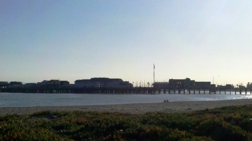
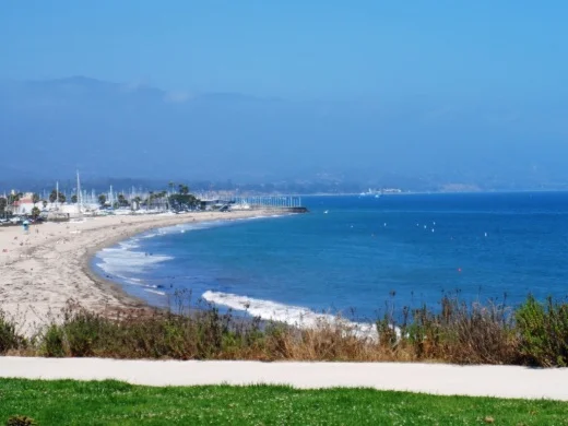
West Beach is located on the west side of Stearns Wharf to the Santa Barbara Harbor. Good for sunbathing, swimming, picnics, kayaking, volleyball and other fun. West Beach is easily accessible and family-friendly, with a wide walkway/bike path. There's also a wading pool, playground and the Los Baños Pool nearby. The beach is adjacent to the Santa Barbara Harbor, where among other things you'll find the Santa Barbara Maritime Museum.

SBHarbor.JPG
It definitely doesn't suck to be at the beach next to the Santa Barbara Harbor at sunset!

It definitely doesn't suck to be at the beach next to the Santa Barbara Harbor at sunset!

Leadbetter Beach and park is between the Santa Barbara Harbor and Shoreline Park, across from Santa Barbara City College. The area has reservable picnic and barbecue sites, outdoor showers, restrooms and a grassy lawn. Popular for beginning surfers and sailboats, as well as sunbathers and fitness enthusiasts.

LeadbetterBeachpark.JPG

Shoreline Park is a 14.6-acre coastal bluff park west of Leadbetter Beach that has a playground, restrooms, picnic tables, barbeques, a group picnic area, benches and beach access stairs.  The park has sweeping views of the coastline, city, and Santa Ynez Mountains. The Torii Gate at the center of the park takes you to a staircase down the bluff to the beach below, where you'll find a narrow and rocky beach area.

View from Shoreline Park looking east towards Leadbetter Beach.

View from Shoreline Park looking east towards Leadbetter Beach.

ShorelineParkSign.JPG

The Mesa beach area between Shoreline Park on the west and Arroyo Burro Beach is accessible via the Mesa Lane Steps near the corner of Mesa Lane and Edgewater Way. This is a residential area where primarily locals access the relatively narrow and rocky beach area below. About a mile away on the east is another beach access point at the eastern end of Camino Al Mar.

Arroyo Burro Beach is a beach park managed by the County of Santa Barbara. It is also referred to as Hendry's Beach, as the Boathouse at Hendry's Beach is located here at 2981 Cliff Drive. Decent sized parking lot with restaurant serving up moderately priced meals and drinks indoors/outdoors, seven days a week from 7:30am to 9pm. Arroyo Burro Beach is a sandy beach, good for surfing, boogie boarding and fishing, with an adjoining park with grassy areas and picnic tables. Restrooms available. From the 101 take Las Positas Road south to Cliff Drive. Turn right and travel 1/2 mile to the park entrance.

Arroyo Burro Beach also welcomes dogs! Dogs must be leashed but the Douglas Family Preserve next door at 2551 Medcliff Road allows dogs to be off leash.

Arroyo Burro Beach

Arroyo Burro Beach

Goleta Beach Park is a 29 acre Santa Barbara County park known for its 1,500 foot fishing pier and sunbathing beaches. Great destination for bicyclists on the area's paved trail system. There are also BBQ picnic areas, volleyball, horseshoes and children's playgrounds as well as the Beachside Bar Cafe. Find your way to Sandspit Road and you're there. Learn more at www.countyofsb.org/parks/parks02.aspx?id=7682.

For beachside parks in Isla Vista, including beach access points at Camino Pescadero Park, El Embarcadero, Camino Corto, Escondido Pass and Camino Majorca, visit www.ivparks.org/parks/descriptions.

El Capitan State Beach is located in Goleta, 17 miles west of Santa Barbara, Exit 117 off of Highway 101. south and you'll see the entrance to the park. A great place for camping, hiking, surfing, picnicking and beach walking. There are rocky tidepools and fun hikes galore here. There's also a 132 site campground open year-round with easy walking access to the beach. Restrooms and showers are nearby. For those into "glamping" (e.g. luxury camping), nearby El Capitan Canyon offers awesome cabins decked out with bedding, kitchenettes and bathrooms as well as deluxe canvas tents and yurts. Visit www.elcapitancanyon.com for more information. Learn more about El Capitan State Beach at www.parks.ca.gov/?page_id=601.

El Capitan State Beach at sundown.

El Capitan State Beach at sundown.

Tree lined trails in El Capitan State Beach Park.

Tree lined trails in El Capitan State Beach Park.

Refugio State Beach is located at 10 Refugio Beach Road in Goleta, about 2 1/2 miles west of El Capitan State Beach. Refugio offers great fishing,  trails and picnic sites. Palm trees planted near Refugio Creek give a distinctive look to the beach and camping area. There are 61 campsites available. Visit www.parks.ca.gov/?page_id=603 for more information.

Jalama Beach County Park is an hour drive from Santa Barbara and a 45-minute drive from Lompoc at 9999 Jalama Road.  It is maintained by the County of Santa Barbara. Have fun at the beach with surfing, whale watching, fishing, horseshoes, picnic areas and more. There's also a popular camping area with over 100 sites as well as seven cabins available. Visit www.countyofsb.org/parks/parks06.aspx?id=9186 or call 805.736.6316.

Butterfly Beach is on the east side of town in Montecito, accessible off of Channel Drive near, of course, Butterfly Lane, across from the Four Seasons Biltmore. No amenities but nice sand, a few benches and dog access. You'll most likely have to find a parking spot on the street. Mainly geared towards locals. You can catch a beautiful sunset from here.

Butterfly Beach in Montecito

Butterfly Beach in Montecito

Lookout Park is a County of Santa Barbara managed park located on four acres on the cliffs of Summerland. Take the Summerland exit off Highway 101 and turn south into the park. Dogs are allowed on leash at this park. There access to a decent strip of beach, Summerland Beach. Also a small playground, restrooms, picnic areas, BBQ grills and more. Visit www.countyofsb.org/parks/parks02.aspx?id=7946 for more info.

Carpinteria area beaches, including Carpinteria State Beach, Tar Pits Park, Carpinteria Bluffs Nature Preserve and Rincon Beach Park, are highlighted at this link.

M*A*S*H Site at Malibu Creek State Park

Malibu Creek State Park is a wilderness wonderland, stretching over 8,000 acres in Calabasas, Agoura and Malibu. The park is a great place for hiking, biking, camping, picnicking and exploring. If you do plan to explore the park, be sure to check out the old M*A*S*H (or "MASH" television series set!

MalibuCreek_Mash1.jpg

Produced by 20th Century Fox, M*A*S*H was filmed from September 1972 to February 1983 over 11 seasons and 256 episodes on CBS. Exterior scenes were filmed at what is now Malibu Creek State Park. Over the years, the ambulance and other props left at the old site became less and less visible as the surrounding brush became overgrown.

In 2007, the set was restored with a shaded picnic area, military vehicles, ambulance, helipad and signpost. Check out the photos below, but, better yet, visit it in person! For more pictures and extensive information about the M*A*S*H set and Malibu Creek State Park, visit www.malibucreekstatepark.org.

MASH_sign.jpg

The M*A*S*H site is easily accessible from the main parking lot at Malibu Creek State Park, mostly on wide fire roads, with one significant hill, a bridge crossing and one somewhat rocky trail section. The path is about 2 1/2 miles each way, so it would be a good idea to bring drinks and snacks.

MalibuCreek_Mash2.JPG
MASH_3.JPG
MASH_4.JPG
MashSite4.JPG
MashSite6.JPG

Fun for the Kids at Local Ventura County Shopping Malls

Shop and plop yourself down while your kids get entertained or, better yet, entertain themselves.  Here is a roundup of kids' activities and play areas at local shopping malls.  In addition to these ongoing activities, seasonal/holiday events are posted regularly here on Conejo Valley Guide.

The Lakes at Thousand Oaks has a nicely appointed outdoor playground with swings, slide and sandbox, large grassy area, two lakes (with ducks usually enjoying it) and waterfall.

Janss Marketplace in Thousand Oaks has Kids Fun Zone arts and crafts on the last Saturday of the month.  There is a small outdoor kids play area for the little ones and an impressive outdoor water fountain, not to mention a NEOS interactive play wall. And Sky Zone Trampoline Park is fun for all ages.

The Commons at Calabasas offers a Kids Club for kids 10 and under on Tuesday nights at 5pm typically March through October as well as an Edwards Theater.

Simi Valley Town Center has a small outdoor kids play area, dragon structure and $2 mini train rides. There’s also the Rockin’ Kids Play Center and Studio Movie Grill to round out the action.

The Oaks Mall in Thousand Oaks offers an indoor kids play area for little ones, Build-a-Bear Workshop, Jumpify Indoor Playground, Galactic Challenge airsoft B target range on level 2 of the outdoor shops area and the AMC Movie Theater.

Pacific View Mall in Ventura has a nice kids' play area near the food court, Bouncing Fun Land and a monthly Kids Club. Soon the Harbor View Carousel will be operating there in the level 2 food court area.

Camarillo Premium Outlets expanded by 220,000 sq ft in April 2009 with The Promenade, which has a Spanish style courtyard area.  In 2019, a kids playground area was constructed at The Promenade.

Playground installed at the Camarillo Premium Outlets in 2019.

Playground installed at the Camarillo Premium Outlets in 2019.

The Promenade at Westlake does not have a kids play area but they do have several nice fountains, live music on most summer weekends, the upscale Cinepolis movie theater and a koi pond.

Malibu Country Mart has a nice outdoor kids' playground area with cool ocean breezes.

The Collection at Riverpark in Oxnard has the 16 screen Century TheatreColor Me Mine ceramics studio and a nice outdoor playground/park area and the Bowlero bowling alley and Jump ‘N Jammin indoor play center. The Annex Food Hall at The Collection offers a Kids Club the last Wednesday of the month. There are board games available daily at Park View Court.

The Pedestrian Tunnel Under Avenida De Los Arboles in Thousand Oaks

There's a pedestrian tunnel that connects the Wildflower Playfield on Avenida De Los Arboles at Canna Street that goes underneath Arboles to Wildwood Neighborhood Park.

At the west end of Wildwood Neighborhood Park is a trail that will take you into Wildwood Park, and from there, you can either loop around back to the main Wildwood Park trailhead at the west end of Arboles, or turn back the way you came.

Wildwood Neighborhood Park was home to the original Wildwood Fort, built in 1967, but torn down in 2009 due to deterioration. New playground equipment was installed in 2021. There is also a playground across the street at Wildflower Playfield, along with restrooms at both parks. More info at www.crpd.org.

Playground at Wildwood Neighborhood Park

Hiking to the Waterfall in Pt Mugu State Park from Rancho Sierra Vista/Satwiwa

One of the most popular hikes in the Rancho Sierra Vista/Satwiwa open space in Newbury Park is to a small waterfall in the adjacent Boney Mountain Wilderness. The hike is about 3 1/2 miles round-trip from the Satwiwa Native American Indian Culture Center and is a moderate hike that can be done by all ages.

Keep in mind that in drought years, there’s sometimes not more than a trickle flowing down this waterfall, while in rainier years like 2023-2024, the waterfall is quite active. In either case, it’s a fun hike to do.

You have two primary options for where to start the hike. You can drive into the Rancho Sierra Vista park entrance on Via Goleta in Newbury Park and park in a lot that is a brief walk to the Culture Center, or you can park at the Wendy Drive and Potrero Road trailhead and add an another two miles, round trip, to your adventure.

The entrance to Rancho Sierra Vista/Satwiwa at Via Goleta, 1 mile west of Reino Road.

The entrance to Rancho Sierra Vista/Satwiwa at Via Goleta, 1 mile west of Reino Road.

The trailhead where Wendy Road ends at Potrero Road in Newbury Park

The trailhead where Wendy Road ends at Potrero Road in Newbury Park

The Satwiwa Native American Indian Culture Center is a small building open from 9am to 5pm on weekends where you can learn about native Chumash items and local wildlife.

The Satwiwa Native American Indian Culture Center is a small building open from 9am to 4pm on weekends (as of April 2024) where you can learn about native Chumash items and local wildlife.

Next to the Culture Center, you'll see multiple paths, all of which can get you to your destination, but the most direct path is the Satwiwa Loop Trail seen on the left, which crosses through a meadow that can be quite green and beautiful in late Winter/early Spring and dry and brown the rest of the year. An alternate route is on the right of the picture above - the Big Sycamore Canyon Trail (paved road) to the Boney Mountain Trail, where you'll take a left.

Satwiwa Loop Trail section that takes you diagonally through the meadow. Seen here when it is nice an green.

Satwiwa Loop Trail section that takes you diagonally through the meadow. Seen here when it is nice and green.

At the end of the meadow, continue straight up a fairly steep hill, where on the right hand side you'll see the Sycamore Canyon Overlook bench shown below.

RSVW_sycoverlook.JPG

bench on sycamore canyon overlook

Hike up the moderately steep and rocky path up the hill behind the bench and you'll reach another fork in the road. If you veer left at this juncture you'll be on the Hidden Valley Overlook Trail within Rancho Sierra Vista/Satwiwa. Stay to the right and you'll be entering the Boney Mountain Wilderness area within Point Mugu State Park.

Sign that shows you the Hidden Valley Overlook Trail is on the left.

Sign that shows you the Hidden Valley Overlook Trail is on the left.

Veering right into the State of California managed Pt Mugu State Park; as you can see, dogs are not allowed in the back country area of the park.

Veering right into the State of California managed Pt Mugu State Park; as you can see, dogs are not allowed in the back country area of the park.

This trail is referred to as Danielson Road, named after the last private owner of these lands. The path down into the canyon is seen below (taken from a higher point en route to the Danielson Monument).

View of the initial section of Danielson Road trail down into the canyon; this is the path you will be taking towards the waterfall.

View of the initial section of Danielson Road trail down into the canyon; this is the path you will be taking towards the waterfall.

Danielson Road is a bit on the steep side but I see folks young and old walking up and down this section all the time. Seen here in very dry conditions.

Danielson Road is a bit on the steep side but I see folks young and old walking up and down this section all the time. Seen here in very dry conditions.

RSVW_waterfalltrailsign.JPG

THIS IS THE OLD SIGN, WHEN IT WAS CALLED DANIELSON ROAD (PRIOR TO 2024)

NEW SIGN IN 2024 SHOWING THE “OLD CABIN TRAIL” INSTEAD OF DANIELSON ROAD.

After .4 mile, you will reach the bottom of the canyon and see the sign above, the final sign indicating you are on your way to the Waterfall Trail. Then you will cross a creek bed, which can have water in it after the rains. The photo taken below in January 2015 shows minimal moisture, making it easy to cross. Some years you may have to rock hop your way a bit over the creek.

RSVW_stream.JPG

Creek bed crossing on the way to the waterfall IN 2015

Creek Crossing in April 2024.

After you cross the creek, the remainder of the trail to the waterfall is single track. Be careful not to come in contact with poison oak often seen on the sides of the trails. For this reason, I would generally not recommend strollers be taken up here.

Soon you will reach the final fork in the road. Go straight and soon you will be at the waterfall. To the right, the Old Cabin Trail (formerly Danielson Road Trail) continues upward to the Danielson Monument.

RSVWaterfallFeb17.JPG

the waterfall in april 2024.

Areas in the Santa Monica Mountains Recreation Area Allowing Dogs on Leash

Pooch on leash

Pooch on leash

The Santa Monica Mountains National Recreation Area is the largest urban national park in the United States at over 150,000 acres, extending from the Hollywood Bowl on the east to Point Mugu at its western end; including the beaches of Santa Monica and Malibu as well as the canyons and peaks extending north to Simi Valley.

Dogs are allowed in a number of areas within the Santa Monica Mountains, as long as they are on leashes that are no more than 6 feet in length. Here is a listing of areas where dogs are allowed:

National Park Service: Arroyo Sequit (has been closed since the Woolsey Fire in 2018), Castro Crest, Cheeseboro/Palo Comado Canyons, Circle X Ranch, Deer Creek Canyon, Paramount Ranch, Peter Strauss Ranch, Rancho Sierra Vista/Satwiwa, Rocky Oaks, Solstice Canyon and Zuma/Trancas Canyons

Santa Monica Mountains Conservancy: Calabasas Peak, Dixie Canyon, Escondido Canyon, Franklin Canyon, Fryman Canyon, Marvin Braude Mulholland Gateway Park, Red Rock Canyon Park, San Vicente Mountain Park, Temescal Gateway Park, Wilacre Park

City of Malibu: Charmlee Wilderness Park, Malibu Bluffs

California State Parks: Pets are NOT allowed on backcountry trails of Topanga, Malibu Creek, Leo Carrillo and Point Mugu State Park, including the Boney Mountain Wilderness.

Canines are not allowed in the backcountry trails of Point Mugu State Park, including the Boney Mountain Wilderness.

Canines are not allowed in the backcountry trails of Point Mugu State Park, including the Boney Mountain Wilderness.

Dogs on leash are allowed at County Line Beach, Leo Carrillo State Park (on beach north of lifeguard tower 3 and campground only), Point Mugu State Park (on beach and campground only in Sycamore Cove and Thornhill Broome Beach), Will Rogers State Historic Park (day-use areas and loop road only)

L.A. City Recreation and Park District: Coldwater Canyon Park, Laurel Canyon Park, Runyon Canyon Park, Temescal Canyon Park

While you're out on the trails with your pooch, remember to pick up after your dog and bring plenty of water and food for you and Fido.

For more information, visit the Anthony C. Beilenson Interagency Visitor Center in Calabasas or www.nps.gov/samo.

Outside of the Santa Monica Mountains, trails in the Conejo Valley, Simi Hills and other local area locations are generally dog-friendly as long as your furry friend is on a leash. 

Dozens and dozens and dozens of local area trails and hikes

DOG PARKS IN AND AROUND VENTURA COUNTY

VISITING STATE PARKS WITH YOUR DOG

Events in Ventura County and Nearby Areas That Have Been Around Over 40 Years

Conejo Valley Guide is the most comprehensive resource ever known to human civilization for events, activities and things to do throughout Ventura County and adjacent areas stretching to Santa Barbara, Malibu and Calabasas, as all of you already know. We've noticed there are numerous events that have taken place in our local community for quite a long time! Let's take a look at the longest duration events in the area - those that have been around at least 40 years.

The 150th Ventura County Fair will take place in summer 2024, the longest duration community event in the county. According to this Fillmore Gazette article, the VC Fair originated in 1874 at Pierpont Bluffs and Hueneme before moving to Seaside Park in Ventura. www.venturacountyfair.org

The Ventura County Fair is the longest-running community event in the area.

The Ventura County Fair is the longest-running community event in the area.

The 100th Anniversary Old Spanish Days Fiesta in Santa Barbara will take place over five days, July 31 to August 4, 2024. It is an annual festival that honors and preserves Santa Barbara’s history, spirit, culture, heritage and traditions with music, art, food, parade, tours and more in various locations. Learn more at www.oldspanishdays-fiesta.org.

The 76th Annual Santa Barbara International Orchid Show took place in March 2024. It is one of the largest and oldest orchid shows in the United States. www.sborchidshow.com

The 74th Annual Oxnard Christmas Tree Lighting Ceremony will occur in December 2024 (generally the first Friday night of the month), making it one of the oldest traditions in Ventura County. And the tree is the County's tallest, at about 110 feet! downtownoxnard.org

The 74th Annual Santa Paula Christmas Parade takes place on the first Sunday after Thankgiving 2024, Quite a tradition for this town that was incorporated in April 1902!

The 70th Annual Semana Nautica 15K in Santa Barbara takes place on July 4, 2024 and on July 4th of each year. It is the oldest foot race on the Central Coast. www.sbrunning.org

The 68th Conejo Valley Days carnival will take place in June 2024. It is the oldest event of its kind in Thousand Oaks. The event officially became called Conejo Valley Days in 1956; previously referred to as a "Community Circus" when held at the old Jungleland (now The Lakes) compound conejovalleydays.us.

Scene from Conejo Valley Days Parade of 1970.

Scene from Conejo Valley Days Parade of 1970.

The 63rd (give or take) Topanga Banjo-Fiddle Contest and Folk Festival took place at King Gillette Ranch in Agoura Hills on May 19, 2024. The event was established in Topanga Canyon and moved around a bit as it grew and moved to the current venue in 1990. It is one of the largest acoustic music events in Southern California. Learn more at www.topangabanjofiddle.org.

The second-longest running Christmas parade in Ventura County is the Camarillo Christmas Parade, which celebrates its 64th annual event in December 2024 www.pvrpd.org

The 62nd Annual Simi Valley Halloween Carnival took place on October 31, 2023 at Rancho Santa Susana Park. Hosted by the Rancho Simi Recreation & Park District, this is one of the longest running Halloween carnivals in Ventura County. www.rsrpd.org

Local area gem and mineral societies have been organizing fun annual shows for decades, including the Ventura Gem & Mineral Society's 61st Annual Gem, Mineral, Fossil and Lapidary Show happened in March 2024. vgms.org/category/gem-show.

The 57th Annual Parade of Lights at Channel Islands Harbor dazzles spectators in December 2023. This may well be the longest-running boat parade in Ventura County. Great fun watching the boats lighted up at the Harbor. www.channelislandsharbor.org

Pierce Brothers Valley Oaks Memorial Park hosted its 55th Annual Easter Sunrise Service on March 31, 2024, quite possibly the longest running local Easter service in Ventura County www.piercebrothersvalleyoaks.com

The 53rd Westlake Village 4th of July Parade and Party in the Park will be taking place yet again on July 4, 2024, making it the longest running Conejo Valley area 4th of July parade. (Like most events, it was cancelled in 2020.) www.wlv.org

The 45th Ventura County Greek Festival will take place at St. Demetrios Greek Orthodox Church in Camarillo in June 2024 www.vcgreekfestival.org.

The Conejo Gem & Mineral Club’s 47th Pageant of a Thousand Gems Show occurred in April 2024 in Newbury Park. www.cgamc.org

The 50th Anniversary Scandinavian Festival at California Lutheran University in Thousand Oaks was a lot of fun in May 2024.  www.scandinavianfest.org

The 47th Annual Ojai Art in the Park event took place on Memorial Day weekend 2024. This I believe is the longest-running outdoor art show within Ventura County. www.ojaiartcenter.org

This is just a tiny fraction of ALL the great events that take place in Ventura County and surrounding areas each year that are highlighted in the Events Calendar and Local Events section of Conejo Valley Guide.