Libbey Bowl and Libbey Park in Ojai
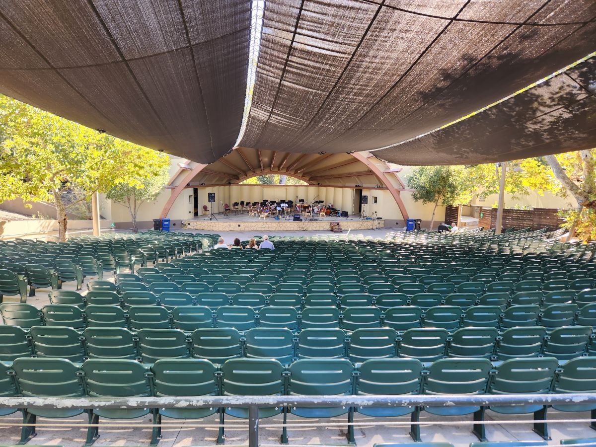
Libbey Bowl and Libbey Park are located in the heart of Ojai near the corner of Ojai Avenue and Signal Street. Libbey Bowl was originally built in 1957 and has been used for the annual Ojai Music Festival, Storytelling Festival, Ojai Day event, holiday celebrations and many other community events through the years. Beginning in 2008, the bowl was renovated and in 2011 was reopened with a new look and design. It accommodates 1,300 people. Learn more about Libbey Bowl at www.libbeybowl.org.

Both Libbey Bowl and Libbey Park are named after Ojai's greatest benefactor, Edward Libbey, a glass manufacturer from Toledo, Ohio. Libbey donated the park to the city in 1917. In front of the park is a shaded pergola along the main "arcade" section of Downtown Ojai.

The park contains a community playground that was designed and built with the help of over 500 volunteers in 2015. It contains a beautiful new play structure and other features that leapfrog what used to be a fairly outdated play area to one of the nicest ones in Ventura County. Visit THIS POST for more information.

This is a photo of the OLD play structure that was replaced in October 2015.

This is a photo of the OLD play structure that was replaced in October 2015.

The new playground!

The new playground!

There are also plenty of benches and seating areas, restrooms, shade trees and tennis courts at Libbey Park. Learn more on the City of Ojai website at www.ojairec.com/460/Libbey-Park.

Santa Barbara Arts & Crafts Show

SantaBarbArtsCrafts.jpg

The Santa Barbara Arts and Crafts Show runs along Cabrillo Boulevard from State Street east about a mile every Sunday as well as Saturdays of major holiday weekends, barring bad weather. Hours are 10 a.m. until 6 p.m. This is truly a unique show in that only local Santa Barbara artists and artisans, around 200 of them, display their original drawings, paintings, sculptures, crafts and photos. This show has operated since 1965 and has been sponsored by the City of Santa Barbara Parks and Recreation Department since 1966.

So make a day of it and check out the show and take in some of the other great activities in Santa Barbara while you're at it. And of course buy something to support local artists!

Learn more about the show at sbparksandrec.santabarbaraca.gov/activities/community-events/santa-barbara-arts-crafts-show.

Ventura Boat Rentals at Ventura Harbor Village

Sailboat.JPG

Ventura Boat Rentals, located at Ventura Harbor Village at 1575 Spinnaker Drive, Ventura rents out electric boats, paddle boats, kayaks, power boats, surf bikes. jet skis and sail boats to the general public.  They also offer narrated harbor tours on weekends and select holidays, public dinner cruises, sunset cocktail cruises, private charters, private parties and public holiday tours. 

Visit www.venturaboatrentals.com or call 805.642.7753 for more information.

We enjoy exploring the Ventura Harbor, thanks to Ventura Boat Rentals.  Lots of small crabs hang out in these rocks.

We enjoy exploring the Ventura Harbor, thanks to Ventura Boat Rentals.  Lots of small crabs hang out in these rocks.

Bark Park Trail in Calabasas

BarkPark_sign.JPG

The Calabasas "Bark Park" is located at 4232 Las Virgenes Road. To get there from the 101, take Las Virgenes Road south just under a mile. The entrance is on the left (east). If you're going fast, it is easy to miss it. It's a nice, local dog park open sunrise to 9pm with plenty of space for the doggies as well as a separate gated kids' play area and plenty of parking.

BarkPark_trailhead.JPG

On the north side of the park is the trailhead to the Bark Park Trail, a 1.2 mile climb that links you up with the New Millenium Loop Trail. Round trip you're talking about a 2 1/2 mile hike.

BarkPark_trail.JPG

It is a nicely maintained trail with a steady, uphill climb. I would call it a moderate climb for the most part. A good walk to take the kids on. But it can get a bit hot up here, so bring water and sunscreen on summer days.

Trail sign at the junction of Bark Park Trail and New Millennium Loop Trail.

Trail sign at the junction of Bark Park Trail and New Millennium Loop Trail.

As you can see from the sign, there's a lot more exploring you can do on these nicely maintained trails in Calabasas.

A view of the Bark Park from the trail above.

A view of the Bark Park from the trail above.

Two Springs Trail and Wildwood Canyon Trails in Wildwood Park, Thousand Oaks

Sign on the west side of the Wildwood Park parking lot after walking down some steps

Sign on the west side of the Wildwood Park parking lot after walking down some steps. (Indian Creek Trail was renamed Two Springs Trail in May 2022.**)

If you enjoy the sound of running water, the Two Springs Trail (formerly Indian Creek Trail) and Wildwood Canyon Trail at Wildwood Park in Thousand Oaks are for you.

The Two Springs Trail can be accessed from the main Wildwood Canyon trailhead area parking lot at the east end of Avenida de los Arboles as well as at a separate trailhead on Arboles, slightly west of the parking lot.

Indian Creek Trail entry point from Avenida de los Arboles

Two Springs Trail (formerly Indian Creek Trail) entry point from Avenida de los Arboles

There are shady sections hidden among the trees and sections in the sun. Most of the trail runs along a creek that flows into Paradise Falls. This is not a completely easy hike as there are some hilly sections, a number of steps, and a stream crossing. That said, there's enough variety to make this a fun and interesting hike with the kids.

Visit the Conejo Open Space Foundation website at cosf.org/trails/wildwood/wildwood-park-easy-hike-moonridge-trail/ for a handy map of these trails.

About half a mile or so into the hike, you'll come across a fairly significant waterfall down below, way below, in the creek. Not as large as Paradise Falls, but definitely prominent. Adjacent to that area is a bench. And from there you have some steps and a stream crossing to make it down to the flatter section of the trail.

The waterfall seen from the Indian Creek Trail. Be careful!

The waterfall seen from the Two Springs Trail (formerly Indian Creek Trail). Be careful!

The bench on the Indian Creek Trail in Wildwood Park

The bench on the Two Springs Trail (formerly Indian Creek Trail) in Wildwood Park

Eventually you get to a bridge. If instead of crossing the bridge, you veer left (southwest), you'll be on the Wildwood Canyon Trail along the creek. This is a wide path that can take you on another little sidetrack loop up the Castillo Trail to Castillo Circle (street). A bit of a steep, roughly 3/8ths of a mile trail to Castillo Circle, where you can walk back to a separate trailhead via Velarde Drive north to San Miguel Circle to the San Miguel Trail. You'll end up back at the bridge area.

The Wildwood Canyon Trail is pretty cool. Fairly flat, wide and runs along a creek. The water they say is mostly urban runoff but fun to check out up close with the kids.

The Wildwood Canyon Trail is pretty cool. Fairly flat, wide and runs along a creek. The water they say is mostly urban runoff but fun to check out up close with the kids.

The Meadows Center next to the bridge has restrooms and a drinking fountain. The Conejo Rec & Park District leads many hikes here for s'mores and fun activities.

The Meadows Center next to the bridge has restrooms and a drinking fountain. The Conejo Rec & Park District leads many hikes here for s'mores and fun activities.

The bridge that intersects the Indian Creek Trail and Wildwood Canyon Trail. Lots of options!

The bridge that intersects the tWO sPRINGS (FORMERLY iNDIAN cREEK) Trail and Wildwood Canyon Trail. Lots of options!

Or, veer right (west) over the bridge, continuing on perhaps the Wildwood Canyon Trail southeast towards the top end entry into the Paradise Falls area (pretty cool to go this way). You can also sidetrack a bit by crossing the bridge and making a sharp right (north) to the short Little Cave Trail** and check out the Little Cave **.

The Indian Cave is really easy to get to. Wear good hiking shoes though as it can get slippery. I slipped several times recently because the sole of my sneakers was so worn down.

The Little Cave (formerly Indian Cave**) is really easy to get to. Wear good hiking shoes though as it can get slippery. I slipped several times recently because the sole of my sneakers was so worn down.

You can return to the parking area by either backtracking up the Two Springs Trail or by taking the trail directly across from the bridge (basically go straight) up the steep, moderately winding path to a public access road (there is overflow parking available here) to the main Mesa Trail. From there, go right (east) back to the parking lot.

I could go on but there are so many different options in Wildwood Park that we'll stop here for now. Here are links to some other options:

THE TEEPEE, LITTLE CAVE AND PARADISE FALLS

LIZARD ROCK

SANTA ROSA LOOP

SANTA ROSA TRAIL AND LOWER BUTTE TRAIL FROM WILDWOOD PARK TO CLU

** The change in name was approved by the Conejo Open Space Conservation Agency (COSCA) in May 2022. COSCA received a request to change the Indian Creek Trail name earlier that year. On its own, the work "Indian" refers to individuals from India, rather than Native Americans, and thus did not accurately reflect the origin of the people to whom it refers.

The Indian Cave and Indian Cave Trail were renamed Little Cave as it was unclear if the cave was naturally formed and/or historically used by Native Americans.

The Indian Creek Trail in Wildwood Park was renamed Two Springs Trail as two natural springs contribute to the stream flow in this portion of the channel.

Wildwood Park in Thousand Oaks

The main entrance into the 1,765 acre Wildwood Park is at the corner of Avenida de los Arboles and Big Sky Drive in Thousand Oaks. The Chumash Indians lived in Wildwood Park for nearly 8,000 years, until the early 19th century, when the Spanish colonized California. Eventually the park became owned by the Janss Corporation, which sold it to the Conejo Recreation and Park District in 1967.

Main trailhead accessible from the parking lot at Ave de los Arboles and Big Sky.

Main trailhead accessible from the parking lot at Ave de los Arboles and Big Sky.

Wildwood Park is an extremely popular hiking and cycling spot and CRPD frequently hosts nature hikes there. The park has 14 trails covering 17 miles, including two year-round waterfalls, Paradise Falls and Little Falls.  Wildwood is known for its spring wildflower displays from January to June.

The park hosted a number of movie/TV productions in the 1930s to the 1960s, including Spartacus, Wuthering Heights, Wagon Train, The Rifleman and Gunsmoke.

Call the CRPD at 805.495.2163 for more information about the park. But for lots of detailed information about Wildwood Park, including trail maps and pictures, visit the Conejo Open Space Foundation website at cosf.org/trails/wildwood.

As far as facilities in the park, there are drinking fountains at the main parking lot as well as at the Teepee, at Paradise Falls and the two restroom areas in the park. One of the restrooms are located at Meadows Center, a small building located across the bridge that is adjacent to the short trail to Little Cave. CRPD often hosts short hikes from the main parking lot to Meadows Center for fun, games and s'mores.

Bridge over creek that connects Wildwood Canyon Trail to Meadows Center, which has restrooms and a drinking fountain.

Bridge over creek that connects Wildwood Canyon Trail to Meadows Center, which has restrooms and a drinking fountain.

The other restrooms are at the bottom of Wildwood Canyon. You can get there by taking the Tepee Trail roughly 1/2 mile to the bottom of the canyon, or alternatively from Paradise Falls about 1/4 mile down the Wildwood Canyon Trail. The Arroyo Conejo Creek runs down from Paradise Falls to here and is fun to explore (keeping in mind still that this is partially urban runoff and thus you don't want to play around in it too much).

Additional restrooms at the bottom of Wildwood Canyon.

Additional restrooms at the bottom of Wildwood Canyon.

Sign at Paradise Falls indicating this particular water is partially urban runoff and best not to swim in.

Sign at Paradise Falls indicating this particular water is partially urban runoff and best not to swim in.

Wildwood2.JPG
Wildwood4_sign.JPG
Tepee Wildwood.JPG

Leo Carrillo State Park in Malibu

LeoCarilloSign.JPG

Leo Carrillo State Park consists of 1.5 miles of beach for swimming, surfing, windsurfing, surf fishing and beachcombing, as well as tide pools, coastal caves and reefs. Giant sycamores shade the main campgrounds.

Among the many great features of Leo Carrillo, the most engaging activity for me and the kids is the tide pools. They are exposed twice daily at low tide and provide hours of engagement with sea stars, sea anemones, mussels, sea slugs and more.

Nature walks and campfire programs are offered and a small visitor center has interpretive displays.

Trails include Yellow Hill Fire Trail for panoramic views of the beach and the Channel Islands, and the steeper Nicholas Flat Trail, which brings you to a pond.

There are 135 family campsites at Leo Carrillo with restrooms and token-operated showers. Visit ReserveCalifornia.com and search for “Leo Carrillo SP” to make reservations.

The park was named after Leo Carrillo (1880-1961), actor, preservationist and conservationist. Leo Carrillo served on the California Beach and Parks commission for 18 years and was instrumental in the state's acquisition of the Hearst property at San Simeon. Leo's greatest fame came from his portrayal of Pancho, the sidekick to Duncan Renaldo's Cisco Kid, an early 1950's TV series.

Leo Carrillo State Park is located at 35000 W. Pacific Coast Highway in Malibu. The park office phone is 310.457.8143. Visit www.parks.ca.gov/?page_id=616 for more information.

Parking is currently $12 in the parking lot for the day (or $3 per hour)...but free on PCH if you can find a spot. There are plenty of parking spots available in the lot. After you park, you can walk in a tunnel underneath PCH to get to the beach.

The muraled tunnel that takes you underneath PCH to Leo Carrillo Beach.

The muraled tunnel that takes you underneath PCH to Leo Carrillo Beach.

Dogs on a leash are allowed in the Park's day use areas, campground and north beach (north of lifeguard tower 3). Dogs are not allowed on backcountry trails or south beach (south of lifeguard tower 3).

DIRECTIONS

The most direct way of getting to Leo Carrillo from the Conejo Valley is via Westlake Boulevard (CA-23) (aka Decker Canyon) south, which for some is a fun 14 mile drive, but for others, not so much. It is a bit winding, hilly, steep at many junctures. I take this route during daytime hours but coming home I'm not too keen on it. After getting to PCH, turn right and drive 2 1/2 miles to get to Leo Carrillo.

Another more popular, though less direct route is via Kanan Road. Either take Kanan Road straight down to PCH, turn right (west) on PCH about 9 miles to Leo Carrillo, or take Kanan to Encinal Canyon, which is about a 3 mile drive on PCH to Leo Carrillo.

Lastly, if you are in Newbury Park, you can take Potrero Road west to Las Posas down to PCH. In about 11 miles you will reach Leo Carrillo.

Malibu Lagoon State Beach

Malibu Lagoon State Beach is where Malibu Creek meets the Pacific Ocean. To get there, park either at the state lot (corner of Pacific Coast Highway and Cross Creek Road) for a fee, along Pacific Coast Highway or across the street in spots available near Malibu Country Mart and the Malibu Civic Center.

The lagoon is serene, with a sandbar of pelicans enjoying their summer day. This beach extends southeast to Surfrider Beach and the Malibu Pier, which is just a short walk away. While you're there try to check out the Adamson House and Malibu Lagoon Museum.

More information at www.parks.ca.gov/?page_id=835. Dogs are not allowed at Malibu Lagoon State Beach and trails.

MalibuLagoon1.5.JPG
MalibuLagoon2.JPG
MalibuLagoon3.JPG
MalibuLagoon4.JPG

Cheeseboro/Palo Comado Canyons in Agoura Hills

CheeseboroPic1.JPG

Cheeseboro and Palo Comado Canyons cover 4,000 acres in the northernmost section of the Santa Monica Mountains National Recreation Area, in the Simi Hills. Stroll to Sulphur Springs or hike to the top of Simi Peak for panoramic views of Oak Park, Agoura Hills and Simi Valley. The Chumash lived in these canyons for thousands of years. Many trails within the canyons may have originated with the Chumash and then were expanded by the ranchers who followed.

Cheeseboro Canyon has some of the best cycling and running trails in the area. The lower trailhead is accessed from Chesebro Road and there is plenty of parking.

On a side note, why is Chesebro Road spelled differently than Cheeseboro Canyon? CLICK HERE

Cheeseboro Canyon Trail (CCT) is a 4.6 mile, fairly easygoing main artery into the park, whereas the 4.4 mile Palo Comado Canyon Trail, which largely parallels the CCT, is much more challenging. The Cheeseboro Ridge Trail also parallels the CCT and seems to be favored by cyclists with its long, rolling hills, though distance runners also will enjoy this trail.  Take CCT up through Sulphur Springs and you'll be running through a small (usually) stream bed and a brief rotten egg smell. Then soon the trail becomes more desert-like as you make your way up to the Sheep Corral Trail and the Shepherds' Flat area. It is really beautiful up there though it can get pretty hot, so carry some water!

While there are plenty of steep hills in this area, this is also a great place for strollers, as many of the trails are quite wide and flat.

The only bathroom that I'm aware of in these trails is at the Chesebro Road trailhead.

Visit www.nps.gov/samo/planyourvisit/cheeseboropalocomado.htm to learn more. The trailhead is located at 5792 Chesebro Road. Contact the visitor center at 805.370.2301. Dogs are allowed but must be on a leash at all times.

Excerpt of Cheeseboro/Palo Comado Canyon Map (Courtesy National Park Service)

Excerpt of Cheeseboro/Palo Comado Canyon Map (Courtesy National Park Service)

CheeseboroPic1.5.JPG
CheeseboroPic2.JPG
CheeseboroPic3.JPG
The Morrison Ranch House in Cheeseboro Canyon was destroyed in the Woolsey Fire of November 2018. Rancher John Morrison and his family occupied this house in 1904 and lived and worked in the home for nearly 60 years. This original ranch house, modif…

The Morrison Ranch House in Cheeseboro Canyon was destroyed in the Woolsey Fire of November 2018. Rancher John Morrison and his family occupied this house in 1904 and lived and worked in the home for nearly 60 years. This original ranch house, modified over the years, dated back to the late 1800s.

The sign survived the Woolsey Fire but the house did not, except for a lone bathtub (hidden by the sign).

The sign survived the Woolsey Fire but the house did not, except for a lone bathtub (hidden by the sign).

Rancho Sierra Vista / Satwiwa in Newbury Park

RanchoSierraVistaEntry.jpg

We are fortunate to have such great trails and views of Boney Peak from in Newbury Park. At Wendy and Potrero is the Western edge of the Santa Monica Mountains where Sycamore Canyon cuts through Rancho Sierra Vista/Satwiwa and Point Mugu State Park.

SatwiwaSign.JPG
Satwiwa.jpg

Roughly a mile easy hike from Wendy/Potrero gets you to the Satwiwa Native American Indian Culture Center where you can explore some native Chumash items and educational information and chat with rangers. This is a nice little hike to take the kids on. There are restrooms and water at the center, which is open from 9 to 5 on weekends.

Learn more about hiking in Rancho Sierra Vista/Satwiwa at THIS LINK.

You can get easier access to the center by parking in the adjacent National Park Service parking lot via Lynn Road to the access road at Via Goleta in Newbury Park.

Another mile and a half of hiking gets you to a small waterfall, which is fun to check out with the kids but somewhat more strenuous of a hike. Note that in recent years (2012-2015), the waterfall has barely flowed due to low rainfall.

Here is more information about the Boney Mountain Trail, leading up to Hidden Valley Overlook, the waterfall and Danielson Monument.

SatwiwaCircle.JPG

Visit www.nps.gov/samo/planyourvisit/rsvsatwiwa.htm for a map and site information on the National Park Service website.

BoneyViewsSatwiwa.jpg
SatwiwaTrails.JPG
WendyPotreroTrailhead.JPG

Trailhead at the corner of Wendy Drive and Potrero Road in Newbury Park. Park on the dirt on the south side of Potrero or on the street on Wendy.

Escondido Canyon Trail and Waterfalls in Malibu

Trailhead on Winding Way

Trailhead on Winding Way

The Edward Albert Escondido Canyon Trail and Waterfalls is located off of Winding Way in Malibu.  It also also referred to as Escondido Falls.

The most unique aspect to Escondido Falls is that it is home to the tallest waterfall in the Santa Monica Mountains at over 150 feet.

That said, in drought years, there is often no sign of waterfall, other than a sparse trickle into Escondido Canyon Creek. But even when that is the case, this is a nice, moderate hike, good for all ages. 

That said, in very wet years, like 2023, you will encounter a number of stream crossing on the trail. Just be aware, as this may not be up your alley.

To get to Escondido Falls from the Conejo Valley/101, take Kanan south to PCH and turn left. You'll be driving just under 2 miles, past Paradise Cove, to the small parking lot on Winding Way and PCH. Turn left onto Winding Way and an immediate left into the parking lot. There's a sign; you can't miss it. The lot has spaces for only around 16 vehicles; it is full, you'll have to find a spot on PCH and make you way from there...but be careful and watch for the plentiful "no parking" signs on PCH.

Parking is $12 (as of June 2023) and takes both cash and credit cards. Parking fees contribute to the ongoing maintenance of the trails, including porta potty cleanings, graffiti and trash removal and partial staffing.)

The parking area is on Winding Way and PCH. The initial section of the hike is along Winding Way is called the Winding Way Trail.

The parking area is on Winding Way and PCH. The initial section of the hike is along Winding Way is called the Winding Way Trail.

The hike is about 4 miles round trip and can be done in as fast as an hour (if you speed walk and don't hang out) or for most, a couple hours.

The first 8/10ths of a mile is along Winding Way to the trailhead. It has a moderate hill but is not that bad. Near the peak of the initial hill, you will need to cross from the left side of the street to the right side as you make your way up. There are signs that ask that you walk on the dirt trail rather than on the street, so try to abide by that. You will be treated to views of beautiful homes and ocean views along this portion of your trek.

After a short final downhill section, you'll reach the trailhead. After an initial left turn that takes you briefly west, most of the rest of the trail to Escondido Falls is a northeast to northerly direction. You'll be treated to lush oak woodlands and greenery year-round.  

Much of the trail looks like this; canopied by oaks and shrub.

Much of the trail looks like this; canopied by oaks and shrub.

Hikers, equestrians and bikers are all welcome on the trail. Dogs too, on leash of course. I have not seen bikers on this trail, however. There are no restrooms, other than a porta-john at the parking lot. No drinking fountains, so bring water. There are trash cans at the trailhead. 

The waterfall is a treat to see but the rest of the hike is quite nice too, largely shaded and not too hilly or technical. There is a net elevation gain from 150' at the trailhead to 325' at the Falls over about a mile, which is not bad.

After the rainy season, you may have to cross the creek a few times as it criss-crosses the trail. There are a couple forks in the road where you may wonder which way to go. Generally speaking, turn left on your way to the falls and that will get you there.

Believe it or not, this is the end of the trail, where the waterfall flows after the rainy season. In late August pictured here, there is a dribble of water flowing into the creek.

Believe it or not, this is the end of the trail, where the waterfall flows after the rainy season. In late August pictured here, there is a dribble of water flowing into the creek.

The parkland ends at the multi-tiered waterfall area and the trail ends. Except, there are paths that can get you to the upper falls. Technically you are not supposed to do this because you are no longer on public land, not to mention you are literally rock climbing your way up there and it can be dangerous.

This is a fun, family-friendly hike that is worth a try. Quite popular, one could argue, too popular, on weekends.

There's one side trail to the east that will give you views of the waterfall when it is flowing. The white-ish area in the upper right hand of this photo is where the waterfall resides.

There's one side trail to the east that will give you views of the waterfall when it is flowing. The white-ish area in the upper right hand of this photo is where the waterfall resides.

Why is it named after Edward Albert? Well, Edward Albert is the only son of actor Eddie Albert, well known for his role on TV sitcom "Green Acres." Edward died at age 55 in 2006. Prior to his death, he was a tireless advocate for preserving Escondido Canyon. The Santa Monica Mountains Conservancy named the area in honor of him several months prior to his death. (1)

Visit the Santa Monica Mountains Conservancy site at mrca.ca.gov/parks/park-listing/escondido-canyon-park for more information.

(1) Los Angeles Times obituary dated 9/27/06 at this link.

Escondido Falls parking as of June 2023.

Lizard Rock Trail From Lizard Rock to Wildwood Canyon at Wildwood Park Thousand Oaks

This is one in a series of posts about trails in the 1,765 acre Wildwood Park in Thousand Oaks.

Lizard Rock at Wildwood Park

Lizard Rock at Wildwood Park

Lizard Rock is a popular 2 mile round trip destination for hikers from the main parking area in Wildwood Park, mostly on the Mesa Trail. It is a moderate hike with an elevation gain of about 300 feet to its peak at 931 feet.

Sign just south of Lizard Rock indication direction of Lizard Rock Trail towards Wildwood Canyon

Sign just south of Lizard Rock indication direction of Lizard Rock Trail towards Wildwood Canyon

After reaching Lizard Rock, some folks (hikers and bikers) venture further south on the Lizard Rock Trail about .8 mile of downhill that takes you past the City of Thousand Oaks Hill Canyon Water Treatment Facility to the Wildwood Canyon area, a drop of about 600 feet in elevation.

View of Hill Canyon Waste Treatment Plan from near Lizard Rock

View of Hill Canyon Waste Treatment Plan from near Lizard Rock

The descent down the Lizard Rock Trail provides nice views into the Santa Rosa Valley as it zigs and zags towards the bottom. You can see Hill Canyon from Lizard Rock but as you move down the hill you will get a much clearer view of this high tech facility that converts wastewater into a reusable water source. You will indeed catch some whiffs of smells that aren't particularly pleasing down there but having been down there myself a number of times, it ain't that bad.

The descent down Lizard Rock Trail

The descent down Lizard Rock Trail

Before you reach the bottom, there are several overlook benches available to take a break as you look towards the Arroyo Conejo, Santa Rosa Valley and beyond.

The first of two overlook benches facing west on the Lizard Rock Trail

The first of two overlook benches facing west on the Lizard Rock Trail

A view of the same bench looking back up (north) towards Lizard Rock (yes, that's the lizard head poking out of the hill on the right).

A view of the same bench looking back up (north) towards Lizard Rock (yes, that's the lizard head poking out of the hill on the right).

And here's the 2nd bench, further down the Lizard Rock Trail. Is that actual green I see up ahead in late September!? Yes it is. Must be drought-tolerant native shrubs!

And here's the 2nd bench, further down the Lizard Rock Trail. Is that actual green I see up ahead in late September!? Yes it is. Must be drought-tolerant native shrubs!

Hill Canyon comes into closer view

Hill Canyon comes into closer view

As you can see, the Lizard Rock Trail starts heading back east as it traverses the Hill Canyon Treatment Plant. Amazing facility. I wouldn't want to go swimming in the green liquid however.

As you can see, the Lizard Rock Trail starts heading back east as it traverses the Hill Canyon Treatment Plant. Amazing facility. I wouldn't want to go swimming in the green liquid however.

At the very bottom of the trail, after you have completely passed the water treatment plant, you see this sign that indicates you are on your way towards Lower Wildwood Canyon.

At the very bottom of the trail, after you have completely passed the water treatment plant, you see this sign that indicates you are on your way towards Lower Wildwood Canyon.

So you've reached the bottom of Wildwood Canyon and other than heading back up that steep Lizard Rock Trail to where you just came from, you can take the more interesting loop route following the Wildwood Canyon Trail to Wildwood Canyon. There are restrooms, drinking fountain and picnic tables in there.

From Wildwood Canyon, either continue onward up the Wildwood Canyon Trail about a third of a mile to Paradise Falls, or the Tepee Trail (yes, this is what it is called on the map), which largely parallels the Wildwood Canyon Trail, up towards, yes, the Tee Pee. Then follow the signs back

There is a great map that covers this Lizard Rock to Paradise Falls to Two Springs (formerly Indian Creek) Trail loop, about 4 1/2 miles in total, on the Conejo Open Space Foundation website at www.cosf.org/website/html/lizard-waterfall-creek.html.

Since we're down at the bottom of the canyon, you will see a sign for "Skunk Hollow." This is a tree-lined area adjacent to the creek with a picnic bench. Kind of nice little area, just around the corner from the waste treatment plant, albeit not within view of the plant. 

And in that area, you will see a sign indicating Eagle Point Trail. Eagle Point Trail is a hilly little 1/3 of a mile alternate route that gets you into Wildwood Canyon. The first section has dozens of steps. The remainder has a few steep sections. Just a small side attraction to check out. 

Eagle Point Trail Wildwood Park

Lake Eleanor Open Space Hike in Westlake Village

For a nice, fairly moderate hike in Westlake Village, take Triunfo Canyon Road south to Highgate Road and head up to the southeast endpoint of Highgate, past Hillsbury Road, to the end of the road, where you'll see a trailhead sign. Park on the street.

It doesn't actually say "Lake Eleanor Open Space Hike" but this is indeed the way to get to this trail maintained by the Conejo Open Space Foundation (COSF).  Walk past the fence on the pavement, and in about 60 steps, the trailhead is on the right. There's no sign. In fact, I've never seen any signs indicating which way to go on this trail. But once you reach this path, for the most part the trail is pretty obvious.

COSF has some helpful images and a trail map at cosf.org/trails/other-trails/easy-lake-eleanor-open-space-hike.

There are some brief, slightly challenging hilly sections on this hike, along with some rocky sections, but for the most part, this trail is perfectly fine for all ages. I generally wouldn't recommend strollers on this trail though because of these sections, but if you have a solid off-road stroller, it is possible.

LakeEleanorTrail.JPG
After record rainfalls in January/February 2017, this place is looking quite green.

After record rainfalls in January/February 2017, this place is looking quite green.

On the left you'll see the beautiful Las Virgenes Reservoir for most of the 1 1/2 mile hike.

You can't go swimming in the Las Virgenes Reservoir but it sure makes for gorgeous views.

You can't go swimming in the Las Virgenes Reservoir but it sure makes for gorgeous views.

Towards the endpoint (Denver Springs Drive), on the right you can look down towards Westlake Boulevard/Decker Canyon and see the eight acre Lake Eleanor. Pretty cool to see from above as it is not accessible to the public.

There is also a trailhead and some parking on Hillsbury Road.

The main trail is on the left; veer right however for best views of Lake Eleanor.

The main trail is on the left; veer right however for best views of Lake Eleanor.

Lake Eleanor along with the Lake Eleanor Dam (also called Banning Dam) and surrounding 529 acres of open space has been named City of Thousand Oaks Historical Landmark #9. 

Lake Eleanor, which is fenced off to protect the wildlife, is clearly visible from the trail.

Lake Eleanor, which is fenced off to protect the wildlife, is clearly visible from the trail.

I love this little hike. It is quiet and peaceful and the views are just wonderful up here. And you are just minutes from civilization.

CLICK HERE FOR DOZENS OF OTHER GREAT HIKING TRAILS AROUND VENTURA COUNTY