The "Maria" Fire Near Santa Paula Burns Over 9,400 Acres Beginning Halloween Night

I was in Newbury Park on Halloween night when I looked up and saw orange flames in the distance. First I mentally freaked out because they looked pretty close by. But after checking out the Ventura County Fire Department (VCFD) “Pulsepoint” page (a web page that shows active and recent incidents in Ventura County), I learned this was most likely a fire on South Mountain, just south of Santa Paula.

Fires definitely can look closer than they actually are at night. Unfortunately, based on a number of recent experiences, I’m getting used to that.

In this case, the fire on South Mountain was clearly seen from the Conejo Valley as the mountain is over 2,300 feet in elevation (which is about 500 feet shorter than Boney Peak here in the Santa Monica Mountains). Although unnerving to see, the flames were easily 10 to 12 miles away from the Conejo Valley, measured point to point.

The fire was called the “Maria” Fire. I’m assuming it was named after something near the scene of the incident. There is a Santa Maria Street in Santa Paula that parallels the north side of South Mountain, so I’m going to assume that was what this wildfire was named after.

South Mountain overlooks the Santa Paula Airport and has the initials “SP” emblazoned on it. There are also oil fields clearly seen on the mountain as well as communications equipment at the top.

What a way to spend Halloween night. Within an hour of its identification, VCFD issued evacuation orders to homes in the perimeter south of the 126, north of Los Angeles Ave, east of Vineyard and west of Balcom Canyon Road.. About 1,800 homes were threatened as the fire crews strategically went into structure protection mode.

The wind driven fire was spreading quickly westbound, while moving slowly in the Santa Paula direction. Somis was also in the path of the fire.

One great thing about social media is that we have much more timely information about local disasters. The VCFD Public Information Officer Twitter account posts frequent updates, available to anyone via web browser at twitter.com/VCFD_PIO. (You don’t need to be a Twitter user to view the Tweets.) I’ve been impressed by the frequency and quality of communications from this VCFD account.

Of course, there are other sources for information, including the vcemergency.com website, which posts incident information, evacuations, emergency shelters and road closures.

As of Saturday, November 2nd at 7 p.m.., the Maria Fire stands at 9,412 acres and is 30% contained. Two structures were destroyed in the fire but at this time, no other structures are threatened. Evacuations orders were lifted at 2 p.m. today. A total of 1,579 total personnel are assigned to the fire, including 262 engines, 7 water tenders, 6 helicopters, 35 hand crews and 10 dozers.

Anticipated full containment is November 8th.

Ventura County Sheriff Office of Emergency Services Emergency Response Website

The Ventura County Sheriff Office of Emergency Services (OES) is responsible for countywide disaster planning, mitigation, response and recovery activities.  OES staff work with all Ventura County departments, ten cities, public and private organizations and community and civic groups. In the event of a disaster, OES is responsible for the County’s Emergency Operations Center, and coordination of the County’s Emergency Management Team, and for recovering the County’s disaster response costs from the state and federal governments.

OES posts information about inf

Read More

Santa Paula Hardware Company / Union Oil Company Building on the National Register of Historic Places

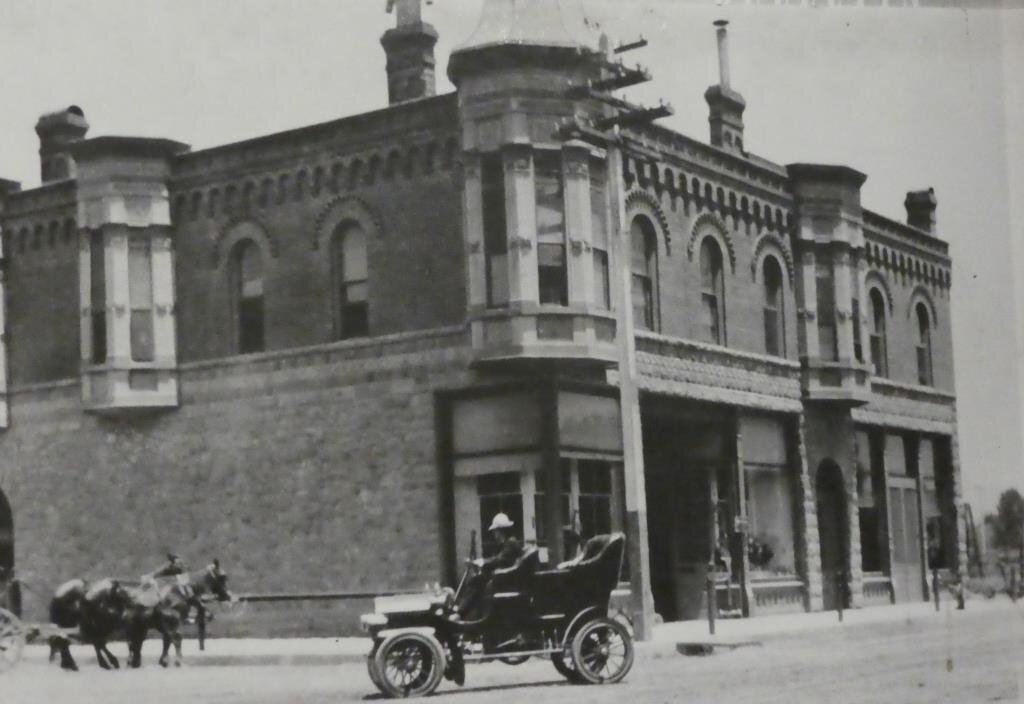
The California Oil Museum at 1001 E. Main Street, Santa Paula (corner of Main and 10th) is the birthplace of Union Oil Company (now part of Chevron). The building was completed on October 17, 1890 and originally was the Santa Paula Hardware Company Building, housing the headquarters of the Union Oil Company on the 2nd floor. Union Oil moved its headquarters to Los Angeles in 1900, but continued to operate a field office out of this building.

The Union Oil Museum was established in 1950. The building was restored to its original appearance for its centennial celebration in 1990. The building is also a California Historical Landmark and is listed on the National Register of Historic Places.

Here’s the California Oil Museum building in April 2019.

Here’s the California Oil Museum building in April 2019.

A view of the building I believe prior to 1900.

A view of the building I believe prior to 1900.

Spencer Furniture store at the historic building in I believe the 1940s.

Spencer Furniture store at the historic building in I believe the 1940s.

Views From the "Scenic Trail" in Sycamore Canyon, Point Mugu State Park

A moderate hike on the Scenic Trail in Sycamore Canyon gets you to views like this.

A moderate hike on the Scenic Trail in Sycamore Canyon gets you to views like this.

Sycamore Canyon in Point Mugu State Park has trails galore to explore, going all the way up, eight miles, to Newbury Park, if you so choose. Located just steps from the Sycamore Canyon Campground is the "Scenic Trail," a moderate trail with some steps that gets you to stunning views of Thornhill Broome Beach, Mugu Rock, the giant sand dune and the majestic Santa Monica Mountains.

The Scenic Trail connects with the Overlook Fire Road, which continues on and eventually connects with the top of the Ray Miller Trail, then on towards the La Jolla Valley. It is lush and stunning when green in late winter/early spring. It gets pretty brown and dry up here towards last spring, summer and fall months. But the great views towards the Pacific never change.

The wonderful scent of wildflowers off of the Scenic Trail, seen here near the junction of Overlook Fire Road, is well worth going out of your way for in the spring.

The wonderful scent of wildflowers off of the Scenic Trail, seen here near the junction of Overlook Fire Road, is well worth going out of your way for in the spring.

Sections of the Juan Bautista de Anza Trail in Ventura County and Nearby Areas

In 1776, while American patriots fought for their independence from England, Spanish Lt. Colonel Juan Bautista de Anza led more than 240 men, women, and children some 1,800 miles to establish a settlement at San Francisco Bay. These families were the first colonists to come overland across the frontier of New Spain into present-day California.

The trail connects Mexico to San Francisco. The group included the settlers, military escorts, support workers and Indian guides, as well as 1,000 head of livestock. The expedition reached “el río de San Francisco “ on June 27, 1776 and established Spain’s northernmost colony in Alta California.

Local hikers will see signs like this on sections of the De Anza Trail.

Local hikers will see signs like this on sections of the De Anza Trail.

The historic trail today is memorialized with a 1,210 mile route extending from Nogales on the U.S./Mexico border through sections of southern Arizona into California. You will see signs from time to time signifying you are on the De Anza Trail.

Locally here in Ventura County, you’ll encounter sections of the De Anza Trail as follows:

There are nearly 17 miles of trail in the Santa Monica Mountains National Recreation Area designated for the Juan Bautista de Anza National Historic Trail.

The coastal parks of San Buenaventura and Emma Wood State beaches, the Faria and Hobson County Parks and the recreation trail on the Ventura beach boardwalk all provide memorable ocean views.

More details on the Ventura County portions of the De Anza Trail at www.anzahistorictrail.org/visit/counties/ventura.

Learn much more at www.anzahistorictrail.org.

Conejo Grade from Green in March to Golden in October 2019

The Conejo Grade is the section of Highway 101 that connects the Conejo Valley with Camarillo.

It is a four mile stretch of freeway with a significant 7% grade. The original Conejo Grade was constructed by the California Highway Commission in 1914-1915 - a route that had 49 twists and turns, making it somewhat hazardous to drive. It has been widened and realigned several times since the 1930s to remove most of those twists and turns.

Today the main change we see along the grade is the color of the surrounding hills; from green in the spring to gold in the fall. Here’s a view of that change in color in March 2019 to October 2019 as seen from the Western Plateau Trail in Thousand Oaks.

EVOLUTION OF THE CONEJO GRADE OVER THE YEARS

Sick With the Flu? Know What To Do!

sick-with-the-flu-large.jpg

Influenza (or flu) is a contagious respiratory illness caused by flu viruses. Most people with flu have mild illness and do not need medical care or antiviral drugs. If you get flu symptoms, in most cases, you should stay home and avoid contact with others except to get medical care.

Know the symptoms of Flu

Flu viruses can cause mild to severe illness, and at times can lead to death. The flu is different from a cold. The flu usually comes on suddenly. People who have flu often feel some or all of these symptoms: Fever* or feeling feverish/chills, cough, sore throat, runny or stuffy nose, muscle or body aches, headaches, fatigue (tiredness). Some people may have vomiting and diarrhea. This is more common in children.

* It’s important to note that not everyone with flu will have a fever.

Take Antiviral Drugs if your doctor prescribes them!

Antiviral drugs can be used to treat flu illness. Antiviral drugs can make illness milder and shorten the time you are sick. They also can prevent serious flu complications.

CDC recommends that antiviral drugs be used early to treat people who are very sick with the flu and people who get flu symptoms who are at high risk of serious flu complications, either because of their age or because they have a high risk medical condition.

Stay Home When Sick

When you are sick, limit contact with others as much as possible. Remember to cover your nose and mouth with a tissue when you cough or sneeze, and throw tissues in the trash after you use them. Stay home for at least 24 hours after your fever is gone except to get medical care or for other necessities.

*Your fever should be gone for 24 hours without the use of a fever-reducing medicine before resuming normal activities.

Treating the flu: www.cdc.gov/flu/treatment/index.html