Tell Me a Little Bit About Newbury Park

Newbury Park is a community located in the western portion of Thousand Oaks. Most of Newbury Park became part of Thousand Oaks by community vote sometime in the 1960s and 1970s. Thousand Oaks became a city in October 1964.

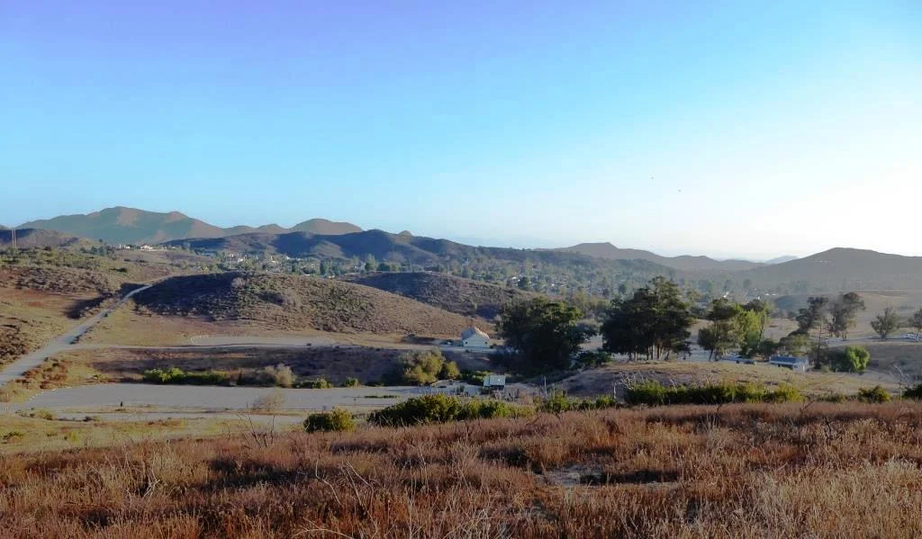
A view of Newbury Park from Boney Peak in October 2021. (Feet Model: Conejo Joe)

Egbert Starr Newbury (Photo Courtesy Conejo Valley Historical Society)

Egbert Starr Newbury (Photo Courtesy Conejo Valley Historical Society)

Newbury Park is named after Egbert Starr Newbury, who owned thousands of acres of land in the Conejo Valley after moving to California from Michigan for health reasons in 1871.  Newbury was one of the three largest Conejo Valley landowners of his time. He and his wife Fannie became the first postmasters in the Conejo Valley in 1875.  The post office was located in a small compound near their house, which was located at the current location of the Thousand Oaks Civic Arts Plaza

The other major landowners at that time were John Edwards, who owned much of the current Newbury Park/Thousand Oaks area north of the 101, and Howard Mills, who owned much of what today is Westlake Village and Hidden Valley.

Edwards sold 10,000 acres of what is now central Thousand Oaks to Edwin and Harold Janss in 1893.  The Janss Corporation also bought thousands of acres of land in Newbury Park (Friedrich, Running Springs and Borchard Ranches) in 1962. 

There were efforts to incorporate Newbury Park in 1961 and 1963 that failed due to a lack of sufficient votes.

Over a 30 month period beginning in the Fall of 1876, only 6 inches of rain fell in the Conejo Valley.  This drought brought devastation to landowners, most of whom lost their crops and livestock and had to sell at a loss or went bankrupt.  The Newburys were no exception; they moved back to the midwest in 1877.  Egbert fell ill to pneumonia in 1880 and passed away at the young age of 36.

The Newburys lived here only six years, so why is it still called Newbury Park? Because the name of the Newburys' post office never changed! The Newbury Park Post Office has changed locations a number of times (including 1602 Newbury Road from May 1968 until it moved to its current location at 3401 Grande Vista Drive in 2013). So the Newbury name and legacy live on here in the Conejo Valley.

Horse tied to a sign indicating the Newbury Park Post Office, in 1909. The location was near modern-day Lynn Ranch. (Courtesy of the Thousand Oaks Library Local History Photo Collection).

Horse tied to a sign indicating the Newbury Park Post Office, in 1909. The location was near modern-day Lynn Ranch. (Courtesy of the Thousand Oaks Library Local History Photo Collection).

Sources: "The Conejo Valley - Old and New Frontiers" by Carol A. Bidwell and "The Newburys of Newbury Park" by Miriam Sprankling

But wait...there's more to Newbury Park! Casa Conejo is also part of the Newbury Park community but is not an incorporated part of Thousand Oaks. It is considered a census-designated place in Ventura County, with its own Municipal Advisory Council. Casa Conejo is the first planned community in Newbury Park and was built in the early 1960s. It has an area of .5 square mile and is bound by Borchard to the south, Old Conejo Road to the north, Jenny Drive (east of Newbury Park High School) to the west and Sequoia Middle School to the east.

TELL ME ABOUT THE HISTORY OF THE STREET NAMES IN THE CASA CONEJO NEIGHBORHOOD

Interested in historical pictures of the area going back to the 1950s?  Click here to read about the work of prolific Conejo Valley photographer, Ed Lawrence. 

Click here for a history of Thousand Oaks. Thousand Oaks is over 56 square miles and Newbury Park represents about 40% of that square footage. Thousand Oaks was incorporated as a city on October 7, 1964.

Three dozen or so things to do in Newbury Park

Another three dozen or so kids' activities in Newbury Park

Yet another three dozen or so sports and fitness activities in Newbury Park

Century Lake at Malibu Creek State Park

According to the Malibu Creek Docents, around 1903, the Crags Country Club constructed a 50 foot tall dam on its 2,000 acre property on what is now Malibu Creek State Park. The dam created a seven acre lake that club members used for fishing and duck hunting.

The Club closed in 1936, and 10 years later, 20th Century Fox Studios purchased the property to film movies and TV shows on what was renamed Century Ranch. The 1968 "Planet of the Apes" featured many prominent scenes shot here.

This is an awesome video showing Planet of the Apes (1968) film scenes at Malibu Creek State Park and local area beaches then and today.

As for the lake, it is now referred to as Century Lake, a hiking destination in Malibu Creek State Park. Only 1 1/2 miles from the parking area, Century Lake is in a secluded area, where you can eat your lunch at the picnic table and enjoy serenity (usually, depending on who else is there). I believe it is fine to wade in the water and even kayak in there if desired. although I've never seen anyone do so.

Century Lake is a left hand turn from the main Crags Road trail, after cresting the only significant hill going down the other side. The only indicator is this narrow sign.

Century Lake is a left hand turn from the main Crags Road trail, after cresting the only significant hill going down the other side. The only indicator is this narrow sign.

The hike has a moderately steep hill in it, but otherwise is quite flat and easy to do with kids and/or a stroller.

Malibu Creek State Park has something for everyone...camping, a visitor center, the "Rock Pool," the M*A*S*H set, the old Reagan Ranch, Century Lake, over 35 miles of trails, rock climbing (near the Rock Pool) and more.

The Century Dam is shown in this image. You don't wanna fall down that dam. Off limits.

The Century Dam is shown in this image. You don't wanna fall down that dam. Off limits.

Building of the Norwegian Grade from Conejo Valley to Camarillo 1909 to 1911

This historic photo and information was generously provided by Gerry Olsen, grandson of Nils Olsen, one of the original settlers in the Conejo Valley in the 1890s.

Back at the turn of the century, farmers in the Conejo Valley grew dry crops like barley and wheat and had to take their harvest to Port Hueneme/Oxnard via horse-drawn wagons. Their only routes were the treacherous (at the time) Potrero Road or down the unpaved Norwegian Grade to Santa Rosa Road.

So in 1909, with a $60 donation from the county to purchase dynamite, Norwegian families Olsen, Pedersen, other volunteers and paid helpers blasted into the hillside from Nils Olsen's property, 1 1/2 miles down to Santa Rosa Road.

It took two to three years to finish the project using the dynamite, manual labor and horse-drawn earth moving machines called Fresno Scrapers (named after a Scottish chap in 1883 who formed the Fresno Agricultural Works to manufacture it).  Here is a historic photo of these early Conejo Valley roadbuilders.

I used to run up the grade from time to time and that was a pretty tight squeeze, with its steep descent and cactus on the side of the road. While most of us take the 23/101 freeways to get to/from Thousand Oaks/Moorpark/Camarillo these days, the Norwegian Grade provides an alternate 2-lane route with a direct linkage to the gritty Norwegian settlers who had the guts and determination to build it.

Oakbrook Regional Park Archaeological Area in Thousand Oaks is City Historical Landmark #5

Oakbrook Regional Park Archaeological Area is located at 3290 Lang Ranch Parkway in Thousand Oaks, south of the intersection of Avenida de los Arboles and Westlake Boulevard.

This 428 acre park is a designated historical landmark by the City of Thousand Oaks and County of Ventura. The Chumash inhabited this area going back as far as 12,000 years ago through the late 1800's. 

The park grounds are open to the public daily from 7 a.m. to 10 p.m.  There are flat hiking trails and a Chumash village reproduction available to explore. The oak trees provide a beautiful canopy for hikers. It is a peaceful place worth exploring. Note that dogs are prohibited from the property.

Located on the property is the Chumash Indian Museum, which contains a large collection of Chumash artifacts. The museum is open on Saturdays and Sundays from 10 a.m. to 4 p.m.

More information on Oakbrook Regional Park at www.crpd.org/park/oakbrook-regional-park.

Hiking and Exploring in Rancho Sierra Vista/Satwiwa in Newbury Park

Entrance to Rancho Sierra VistaSatwiwa at Lynn Road and Via Goleta in Newbury Park

Located on the western edge of the Santa Monica Mountains National Recreation Area, Rancho Sierra Vista/Satwiwa is accessible in Newbury Park at the intersection of Lynn Road and Via Goleta. This area spans from Potrero Road on the north and connects to Point Mugu State Park on the south.

Ranching in the area dates back to the early 1800s, when Spanish soldiers were granted 48,672 acres of land, "Rancho El Conejo," which through the years was subdivided and sold to other landowners. One of these ranchers was Carl Beal, who in 1937 named the area Rancho Sierra Vista "Mountain View Ranch." The last private landowner in the area was Richard Danielson, whose family farmed and ranched the area for 32 years. Danielson donated 5,585 acres of the ranch to the State of California, which became part of Point Mugu State Park, and sold 850 acres, including the horse ranch, to the National Park Service in 1980.

Sign at Danielson Monument accessible via Danielson Road/Old Boney Trail.

Sign at Danielson Monument accessible via Danielson Road/Old Boney Trail.

The Satwiwa Native American Indian Natural Area is a bike/horse free area within Rancho Sierra Vista/Satwiwa of roughly 60 acres. Located on the northwest corner of this area, just a short walk from visitor parking, is the Satwiwa Native American Culture Center.

The Culture Center is staffed from 9 a.m. to 4 p.m. most weekends with a park ranger or other staff. It is a small building that also hosts a variety of educational Chumash and wildlife items. NPS BROCHURE AND TRAIL MAP

Learn more about RSV at www.nps.gov/samo/planyourvisit/rsvsatwiwa.htm.

SatwiwaSign.JPG

The area is a popular destination for hikers with a variety of well maintained trails. Note, however, that bicycles and horses are not allowed in the "Satwiwa Natural Area" section (see map below).

Map excerpt courtesy of National Park Service.

Map excerpt courtesy of National Park Service.

The Satwiwa Loop Trail is an easy, 2 mile trail that starts at the Culture Center through grasslands, past the old windmill and back around, with several extensions for those looking to do a little more.

SatwiwaLoopTrail_sign.jpg

There's the Lower Loop Trail and the Upper Loop Trail that is a bit of a zig-zaggy trail with wooden footings placed by volunteers to help hikers navigate. The Upper Loop Trail runs past the "Old Windmill" pictured below.

Satwiwa Lower Loop sign at intersection of Danielson Road trail.

Satwiwa Lower Loop sign at intersection of Danielson Road trail.

The old windmill at the northeast corner of the Satwiwa Loop Trail (Upper Loop). (Windmill was knocked down by high winds in December 2016 and is still down as of MAY 2024).

You can also park at the Wendy and Potrero trailhead and walk to the Culture Center via the Wendy Trail, about a mile each way.

Wendy Trail trailhead at the intersection of Wendy and Potrero in Newbury Park

Wendy Trail trailhead at the intersection of Wendy and Potrero in Newbury Park

It is pretty dry in here most of the year but after the winter/spring rains, the green stages a comeback.

It is pretty dry in here most of the year but after the winter/spring rains, the green stages a comeback.

Another trail to explore is the 1 mile Ranch Overlook Trail that takes you from just west of the Satwiwa Native American Indian Culture Center, up a hill (where you can indeed look down toward the old ranch area, parking area and restrooms) to the main entrance and to the Palomino Trail in the Rancho Potrero Open Space.

Ranch Overlook Trail

Ranch Overlook Trail

One of my favorite trails in Rancho Sierra Vista/Satwiwa is the Hidden Valley Overlook Trail. This challenging, fairly steep trail branches off from the Satwiwa Loop Trail on the southeast, past the bench at the Upper Sycamore Canyon Overlook, via the Boney Mountain Trail/Danielson Road.

The popular bench at Upper Sycamore Canyon Overlook. Photo taken April 4, 2014, approximately 11 months after the devasting Springs Fire of 2013.

The popular bench at Upper Sycamore Canyon Overlook. Photo taken April 4, 2014, approximately 11 months after the devasting Springs Fire of 2013.

Roughly 700 feet past the Upper Sycamore Canyon bench is a juncture where you can either veer right into Point Mugu State Park and the Boney Mountain Wilderness, where you can walk down, over a stream (or a dry stream bed as the case may be), towards the popular "waterfall" (which in recent years has been not much more than a trickle) and the Danielson Monument. CLICK HERE for details.

If you veer left at the juncture, you'll see the Hidden Valley Overlook trail sign.

HiddenValleyOverlook_sign.jpg

The trail is steep and rocky and reaches an end point in about half a mile. If you are up to the challenge, you will be rewarded with sweeping views of Newbury Park, the Channel Islands, Sycamore Canyon and Boney Mountain.

Views from halfway up the Hidden Valley Overlook Trail towards the Satwiwa Native American Indian Natural Area

Views from halfway up the Hidden Valley Overlook Trail towards the Satwiwa Native American Indian Natural Area

At the end of the trail is the Hidden Valley overlook, where you will be able to peek into the not-so-hidden-anymore Hidden Valley and its peaceful ranches. As a final reward for your effort, it's all downhill the way back. Be sure to wear solid hiking shoes as the trails are a bit technical.

Peek at Hidden Valley at the end of the Hidden Valley Overlook Trail.

Peek at Hidden Valley at the end of the Hidden Valley Overlook Trail.

View of Santa Cruz Island, one of the Channel Islands, from Hidden Valley Overlook trail

View of Santa Cruz Island, one of the Channel Islands, from Hidden Valley Overlook trail

To learn more, visit the Anthony C. Beilenson Visitor Center at 26876 Mulholland Highway, Calabasas or visit www.nps.gov/samo or call 805.370.2301.

Dogs are allowed in Rancho Sierra Vista/Satwiwa as long as they are on a leash no longer than 6 feet. But please, pick up after your pet. Dogs are not allowed in the Point Mugu State Park / Boney Mountain Wilderness back country trails, though they are allowed on paved roads, such as the Big Sycamore Canyon Trail road.

The Saticoy Southern Pacific Railroad Depot is on the National Register of Historic Places

Saticoy Southern Pacific Railroad Depot seen from Alelia Ave

The Saticoy Southern Pacific Railroad Depot is located in the unincorporated community of Saticoy at 11220 Azahar Street.

The depot, built in 1887, was designated Ventura County Historic Landmark no. 176 in May 2016. It was listed on the National Register of Historic Places in 2018.

The depot was built by the Southern Pacific Railroad along the line that was being constructed from Los Angeles to Ventura in 1887. The original town of Saticoy was laid out near the new depot. Its name comes from the Chumash village of Sa’aqtik’oy. 

The Saticoy Depot served rail that traveled through the Santa Clara Valley between Saugus to Ventura County. It was one of 14 Southern Pacific Railroad Depots in Ventura County - the others were Oxnard, Santa Susana, Santa Paula, Fillmore, Piru, Ojai, Camarillo, Moorpark, Sespe, Camulos, Somis, Montalvo and downtown Ventura. Only six of these remain today.

Saticoy Depot in 1956 (Museum of Ventura County)

Scene From The Oaks Mall at Christmastime in December 1982

Here’s a scene from The Oaks shopping mall, courtesy of the Thousand Oaks Library’s Conejo Through the Lens collection, from December 1982.

The view is from the upper level of the east end of the mall. Looking west on the right you can see House of Fabrics and Hot Dog on a Stick and below, Wallpapers to Go.

And below is a more current view of The Oaks, albeit from a different vantage point in the mall.

The Macerich Company, which owns 47 million square feet of real estate consisting primarily of interests in 44 regional town centers. announced in its 3rd quarter financial report last month "We are under contract to sell The Oaks for $157 million, and expect to close** during the fourth quarter of 2024, subject to customary closing conditions." Real estate news site "The Real Deal" indicates the buyer is Stockdale Capital Partners. So perhaps we'll see some changes in the future. Macerich has owned the mall since 2002. The mall originally opened in 1978.