Hiking and Exploring in Rancho Sierra Vista/Satwiwa in Newbury Park

Entrance to Rancho Sierra VistaSatwiwa at Lynn Road and Via Goleta in Newbury Park

Located on the western edge of the Santa Monica Mountains National Recreation Area, Rancho Sierra Vista/Satwiwa is accessible in Newbury Park at the intersection of Lynn Road and Via Goleta. This area spans from Potrero Road on the north and connects to Point Mugu State Park on the south.

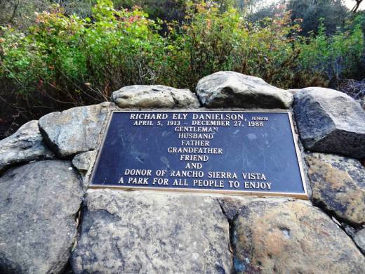
Ranching in the area dates back to the early 1800s, when Spanish soldiers were granted 48,672 acres of land, "Rancho El Conejo," which through the years was subdivided and sold to other landowners. One of these ranchers was Carl Beal, who in 1937 named the area Rancho Sierra Vista "Mountain View Ranch." The last private landowner in the area was Richard Danielson, whose family farmed and ranched the area for 32 years. Danielson donated 5,585 acres of the ranch to the State of California, which became part of Point Mugu State Park, and sold 850 acres, including the horse ranch, to the National Park Service in 1980.

Sign at Danielson Monument accessible via Danielson Road/Old Boney Trail.

Sign at Danielson Monument accessible via Danielson Road/Old Boney Trail.

The Satwiwa Native American Indian Natural Area is a bike/horse free area within Rancho Sierra Vista/Satwiwa of roughly 60 acres. Located on the northwest corner of this area, just a short walk from visitor parking, is the Satwiwa Native American Culture Center.

The Culture Center is staffed from 9 a.m. to 4 p.m. most weekends with a park ranger or other staff. It is a small building that also hosts a variety of educational Chumash and wildlife items. NPS BROCHURE AND TRAIL MAP

Learn more about RSV at www.nps.gov/samo/planyourvisit/rsvsatwiwa.htm.

SatwiwaSign.JPG

The area is a popular destination for hikers with a variety of well maintained trails. Note, however, that bicycles and horses are not allowed in the "Satwiwa Natural Area" section (see map below).

Map excerpt courtesy of National Park Service.

Map excerpt courtesy of National Park Service.

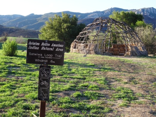
The Satwiwa Loop Trail is an easy, 2 mile trail that starts at the Culture Center through grasslands, past the old windmill and back around, with several extensions for those looking to do a little more.

SatwiwaLoopTrail_sign.jpg

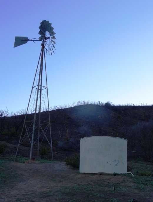
There's the Lower Loop Trail and the Upper Loop Trail that is a bit of a zig-zaggy trail with wooden footings placed by volunteers to help hikers navigate. The Upper Loop Trail runs past the "Old Windmill" pictured below.

Satwiwa Lower Loop sign at intersection of Danielson Road trail.

Satwiwa Lower Loop sign at intersection of Danielson Road trail.

The old windmill at the northeast corner of the Satwiwa Loop Trail (Upper Loop). (Windmill was knocked down by high winds in December 2016 and is still down as of MAY 2024).

You can also park at the Wendy and Potrero trailhead and walk to the Culture Center via the Wendy Trail, about a mile each way.

Wendy Trail trailhead at the intersection of Wendy and Potrero in Newbury Park

Wendy Trail trailhead at the intersection of Wendy and Potrero in Newbury Park

It is pretty dry in here most of the year but after the winter/spring rains, the green stages a comeback.

It is pretty dry in here most of the year but after the winter/spring rains, the green stages a comeback.

Another trail to explore is the 1 mile Ranch Overlook Trail that takes you from just west of the Satwiwa Native American Indian Culture Center, up a hill (where you can indeed look down toward the old ranch area, parking area and restrooms) to the main entrance and to the Palomino Trail in the Rancho Potrero Open Space.

Ranch Overlook Trail

Ranch Overlook Trail

One of my favorite trails in Rancho Sierra Vista/Satwiwa is the Hidden Valley Overlook Trail. This challenging, fairly steep trail branches off from the Satwiwa Loop Trail on the southeast, past the bench at the Upper Sycamore Canyon Overlook, via the Boney Mountain Trail/Danielson Road.

The popular bench at Upper Sycamore Canyon Overlook. Photo taken April 4, 2014, approximately 11 months after the devasting Springs Fire of 2013.

The popular bench at Upper Sycamore Canyon Overlook. Photo taken April 4, 2014, approximately 11 months after the devasting Springs Fire of 2013.

Roughly 700 feet past the Upper Sycamore Canyon bench is a juncture where you can either veer right into Point Mugu State Park and the Boney Mountain Wilderness, where you can walk down, over a stream (or a dry stream bed as the case may be), towards the popular "waterfall" (which in recent years has been not much more than a trickle) and the Danielson Monument. CLICK HERE for details.

If you veer left at the juncture, you'll see the Hidden Valley Overlook trail sign.

HiddenValleyOverlook_sign.jpg

The trail is steep and rocky and reaches an end point in about half a mile. If you are up to the challenge, you will be rewarded with sweeping views of Newbury Park, the Channel Islands, Sycamore Canyon and Boney Mountain.

Views from halfway up the Hidden Valley Overlook Trail towards the Satwiwa Native American Indian Natural Area

Views from halfway up the Hidden Valley Overlook Trail towards the Satwiwa Native American Indian Natural Area

At the end of the trail is the Hidden Valley overlook, where you will be able to peek into the not-so-hidden-anymore Hidden Valley and its peaceful ranches. As a final reward for your effort, it's all downhill the way back. Be sure to wear solid hiking shoes as the trails are a bit technical.

Peek at Hidden Valley at the end of the Hidden Valley Overlook Trail.

Peek at Hidden Valley at the end of the Hidden Valley Overlook Trail.

View of Santa Cruz Island, one of the Channel Islands, from Hidden Valley Overlook trail

View of Santa Cruz Island, one of the Channel Islands, from Hidden Valley Overlook trail

To learn more, visit the Anthony C. Beilenson Visitor Center at 26876 Mulholland Highway, Calabasas or visit www.nps.gov/samo or call 805.370.2301.

Dogs are allowed in Rancho Sierra Vista/Satwiwa as long as they are on a leash no longer than 6 feet. But please, pick up after your pet. Dogs are not allowed in the Point Mugu State Park / Boney Mountain Wilderness back country trails, though they are allowed on paved roads, such as the Big Sycamore Canyon Trail road.

Cycling Clubs and Groups In and Around Ventura County

CyclistsCam.JPG

Any given Sunday morning I come across hundreds of bicyclists on my morning runs in the Thousand Oaks area and throughout Ventura County.

Here are some local cycling groups:

CLICK HERE for some family-friendly friendly bike path options around Ventura County.

And for some local BMX track options, Freedom Park BMX Raceway in Camarillo

Bike shops in the local area:

EBike shops:

Public Beaches In and Around Santa Barbara

We've compiled highlights of public beaches ranging from Malibu to Carpinteria. so how about if we stretch the boundaries of that list further west a bit to include some of the popular beaches of Santa Barbara.

The City of Santa Barbara maintains four miles of beaches, including East Beach, West Beach, Leadbetter Beach, Shoreline Park and the Mesa neighborhood. The city offers a number of parking lots along the waterfront. Dogs not allowed on city beaches from East Beach to Leadbetter.

East Beach stretches from Stearns Wharf on the west to roughly across the street from the Santa Barbara Zoo. There are over a dozen volleyball courts, a play area, the full service East Beach Grill and picnic facilities. The Cabrillo Pavilion Bathhouse at 1118 East Cabrillo Boulevard is open M-F from 8am to 5pm and has showers, lockers, a weight room, beach wheelchairs and volleyball rental.

West side of East Beach looking towards Stearns Wharf.

West side of East Beach looking towards Stearns Wharf.

There's a also a fun bike path stretching from here to West Beach and Leadbetter. Bring your bikes or rent them across the street on Cabrillo Boulevard near State Street. And on Sundays year-round is the Santa Barbara Arts & Crafts Show.

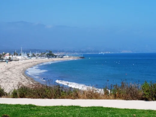
West Beach is located on the west side of Stearns Wharf to the Santa Barbara Harbor. Good for sunbathing, swimming, picnics, kayaking, volleyball and other fun. West Beach is easily accessible and family-friendly, with a wide walkway/bike path. There's also a wading pool, playground and the Los Baños Pool nearby. The beach is adjacent to the Santa Barbara Harbor, where among other things you'll find the Santa Barbara Maritime Museum.

SBHarbor.JPG
It definitely doesn't suck to be at the beach next to the Santa Barbara Harbor at sunset!

It definitely doesn't suck to be at the beach next to the Santa Barbara Harbor at sunset!

Leadbetter Beach and park is between the Santa Barbara Harbor and Shoreline Park, across from Santa Barbara City College. The area has reservable picnic and barbecue sites, outdoor showers, restrooms and a grassy lawn. Popular for beginning surfers and sailboats, as well as sunbathers and fitness enthusiasts.

LeadbetterBeachpark.JPG

Shoreline Park is a 14.6-acre coastal bluff park west of Leadbetter Beach that has a playground, restrooms, picnic tables, barbeques, a group picnic area, benches and beach access stairs.  The park has sweeping views of the coastline, city, and Santa Ynez Mountains. The Torii Gate at the center of the park takes you to a staircase down the bluff to the beach below, where you'll find a narrow and rocky beach area.

View from Shoreline Park looking east towards Leadbetter Beach.

View from Shoreline Park looking east towards Leadbetter Beach.

ShorelineParkSign.JPG

The Mesa beach area between Shoreline Park on the west and Arroyo Burro Beach is accessible via the Mesa Lane Steps near the corner of Mesa Lane and Edgewater Way. This is a residential area where primarily locals access the relatively narrow and rocky beach area below. About a mile away on the east is another beach access point at the eastern end of Camino Al Mar.

Arroyo Burro Beach is a beach park managed by the County of Santa Barbara. It is also referred to as Hendry's Beach, as the Boathouse at Hendry's Beach is located here at 2981 Cliff Drive. Decent sized parking lot with restaurant serving up moderately priced meals and drinks indoors/outdoors, seven days a week from 7:30am to 9pm. Arroyo Burro Beach is a sandy beach, good for surfing, boogie boarding and fishing, with an adjoining park with grassy areas and picnic tables. Restrooms available. From the 101 take Las Positas Road south to Cliff Drive. Turn right and travel 1/2 mile to the park entrance.

Arroyo Burro Beach also welcomes dogs! Dogs must be leashed but the Douglas Family Preserve next door at 2551 Medcliff Road allows dogs to be off leash.

Arroyo Burro Beach

Arroyo Burro Beach

Goleta Beach Park is a 29 acre Santa Barbara County park known for its 1,500 foot fishing pier and sunbathing beaches. Great destination for bicyclists on the area's paved trail system. There are also BBQ picnic areas, volleyball, horseshoes and children's playgrounds as well as the Beachside Bar Cafe. Find your way to Sandspit Road and you're there. Learn more at www.countyofsb.org/parks/parks02.aspx?id=7682.

For beachside parks in Isla Vista, including beach access points at Camino Pescadero Park, El Embarcadero, Camino Corto, Escondido Pass and Camino Majorca, visit www.ivparks.org/parks/descriptions.

El Capitan State Beach is located in Goleta, 17 miles west of Santa Barbara, Exit 117 off of Highway 101. south and you'll see the entrance to the park. A great place for camping, hiking, surfing, picnicking and beach walking. There are rocky tidepools and fun hikes galore here. There's also a 132 site campground open year-round with easy walking access to the beach. Restrooms and showers are nearby. For those into "glamping" (e.g. luxury camping), nearby El Capitan Canyon offers awesome cabins decked out with bedding, kitchenettes and bathrooms as well as deluxe canvas tents and yurts. Visit www.elcapitancanyon.com for more information. Learn more about El Capitan State Beach at www.parks.ca.gov/?page_id=601.

El Capitan State Beach at sundown.

El Capitan State Beach at sundown.

Tree lined trails in El Capitan State Beach Park.

Tree lined trails in El Capitan State Beach Park.

Refugio State Beach is located at 10 Refugio Beach Road in Goleta, about 2 1/2 miles west of El Capitan State Beach. Refugio offers great fishing,  trails and picnic sites. Palm trees planted near Refugio Creek give a distinctive look to the beach and camping area. There are 61 campsites available. Visit www.parks.ca.gov/?page_id=603 for more information.

Jalama Beach County Park is an hour drive from Santa Barbara and a 45-minute drive from Lompoc at 9999 Jalama Road.  It is maintained by the County of Santa Barbara. Have fun at the beach with surfing, whale watching, fishing, horseshoes, picnic areas and more. There's also a popular camping area with over 100 sites as well as seven cabins available. Visit www.countyofsb.org/parks/parks06.aspx?id=9186 or call 805.736.6316.

Butterfly Beach is on the east side of town in Montecito, accessible off of Channel Drive near, of course, Butterfly Lane, across from the Four Seasons Biltmore. No amenities but nice sand, a few benches and dog access. You'll most likely have to find a parking spot on the street. Mainly geared towards locals. You can catch a beautiful sunset from here.

Butterfly Beach in Montecito

Butterfly Beach in Montecito

Lookout Park is a County of Santa Barbara managed park located on four acres on the cliffs of Summerland. Take the Summerland exit off Highway 101 and turn south into the park. Dogs are allowed on leash at this park. There access to a decent strip of beach, Summerland Beach. Also a small playground, restrooms, picnic areas, BBQ grills and more. Visit www.countyofsb.org/parks/parks02.aspx?id=7946 for more info.

Carpinteria area beaches, including Carpinteria State Beach, Tar Pits Park, Carpinteria Bluffs Nature Preserve and Rincon Beach Park, are highlighted at this link.

Roller Skating, Roller Blading, Ice Skating and Skateboarding Around Ventura County

iStock_icehockey.jpg

Looking for some wheel fun around the Conejo Valley and Greater Ventura County? Look no further than this list of nearby skating, blading and boarding venues in and around the area.

ICE SKATING

LA Kings Iceoplex Ice Arena in Simi Valley

Hockey Alley Ice Skating Training Facility in Newbury Park

ROLLER SKATING, ROLLER HOCKEY

Skating Plus Indoor Roller Rink in Ventura

Tri-Valley Roller Hockey League in Calabasas

CLOSED

Channel Islands Ice Center in Oxnard (closed its doors in April 2016 but is looking to raise funds for a new home)

Skatelab Skate Park in Simi Valley closed its doors 1/6/19 after 21 years in operation, but its founder indicated a new location is coming.

The Holiday Ice Rink at The Lakes at Thousand Oaks operated annually from mid-November to January until the 2019-2020 holiday season.

The Conejo Valley Ice Skating Rink opened in 1977 at 510 North Ventu Park Road in Newbury Park (which today is the address of Hampton Inn & Suites). The facility closed its doors in 1994, after 17 years in business.

Ride On Therapeutic Horsemanship in Newbury Park Serves the Disabled

Ride On Therapeutic Horsemanship teaches horseback riding to children and adults with physical and mental disabilities. Founded in 1994, Ride On has given over 100,000 safe, effective and individualized lessons and therapy treatments. Serving the Conejo Valley, Ride On's Newbury Park site is operated in partnership with the Conejo Recreation and Park District. In the San Fernando Valley, Chatsworth is home to a newer facility and 3 acre ranch.

Ride On serves over 200 riders each week at its 13 acre Newbury Park location at 401 Ronel Court and its Chatsworth location. The minimum age for therapeutic riding is 4 years old and all disabilities are served, both mental and physical.

Therapeutic riding is a unique combination of sport, recreation and education. Specially trained NARHA qualified instructors use their knowledge of disabilities to teach horsemanship skills to riders with varying ability levels. A typical therapeutic riding lesson involves safety on and around horses, warm up exercises, games and riding skills including equitation and obstacle. Increased balance, strength and self esteem are some of the benefihts of this wonderful recreational activity.

Ride On also offers hippotherapy for clients as young as 2 years old. Hippotherapy is the use of the horse’s movement for rehabilitation. Licensed Therapists properly position the patient on the horse, analyze the patient’s response and direct the horse’s movement to achieve specific patient treatment goals. Hippotherapy facilitates improved balance, posture, mobility, communication and behavior for patients of all ages and many disabilities.

Ride On’s primary funding sources are income from lessons, grants, special events and private donations. Ride On is a 501(c)(3) charitable organization. Visit www.rideon.org or call 805.375.9078 for more information.

Medi-Cal is California's Medicaid Healthcare Program

Medi-Cal is California’s Medicaid healthcare program that provides comprehensive health coverage for people with low or no income. In Ventura County, Medi-Cal is administered by the Human Services Agency. To qualify for Medi-Cal, you have to live in California and meet program eligibility rules.

Medi-Cal primarily serves low-income individuals, including families with children, seniors, persons with disabilities, children in foster care, pregnant women, and low-income people with specific diseases such as tuberculosis, breast cancer, or HIV/AIDS. CalWORKs participants and Foster Care are automatically eligible for Medi-Cal.

Learn more and apply for Medi-Cal in Ventura County at www.ventura.org/human-services-agency/medi-cal.

Gold Coast Health Plan was created by the Ventura County Medi-Cal Managed Care Commission in 2010 to administer healthcare benefits to the 200,000 Medi-Cal beneficiaries who live in Ventura County.

How do you qualify for Medi-Cal benefits?

  • If your income is below 138% poverty level, which in 2023 is $20,121 for one person, $27,214 for a family of two and $41,400 for a family of four, and

  • If you are 65+, blind, disabled, under 21, pregnant, in a skilled nursing facility, a parent or caretaker relative of an age eligible child or have screened for breast or cervical cancer. A new law gives full scope Medi-Cal to adults 50 years of age or older access to Medi-Cal.

  • If you are enrolled in CalFresh, SSI/SSP, CalWorks, Refugee Assistance or Foster Care.

If your income is too high to qualify for Medi-Cal, you may qualify for partially subsidized health insurance premiums through Covered California.

Jumping and Climbing Options In and Around Ventura County

If your kids are bouncing off the walls around the house and need to jump off some steam, perhaps they need a new environment for jumping and/or climbing in and around Ventura County. Here are some options to consider.

Sky Zone (formerly DojoBoom and Defy) Extreme Air Sports opened at the Janss Marketplace in Thousand Oaks in November 2017, offering over 50,000 square feet of trampolines, launching decks, foam pits, obstacle course and much more.

Sky Zone Trampoline Park is located at 2825 Johnson Drive in east Ventura. Similar to Sky High, Sky Zone offers wall to wall trampolines with open jump sessions, a "SkySlam" court and more.

Boulderdash Indoor Rock Climbing at 880 Hampshire Road, Suite A, Thousand Oaks, is a 10,000 sq ft climbing area with sections ranging from 25 feet to 45 feet tall. Fun for all ages.

An additional Boulderdash Indoor Rock Climbing opened at 2879 Seaborg Avenue, Suite 101, Ventura in January 2019. This facility is also 10,000 sq ft.

The Agoura Hills/Calabasas Community Center at 27040 Malibu Hills Road, Calabasas features, among other things, a 35 foot rock climbing wall. (Center has been closed pending renovations; anticipated to reopen in late fall 2023.)

Santa Barbara Rock Gym is an 8,500 sq ft facility located at 322 State Street, Santa Barbara.

Not for the inexperienced...rock climbing at Westward Beach in Malibu.

Not for the inexperienced...rock climbing at Westward Beach in Malibu.

For more seasoned climbers, there is a sheer cliff used by rock climbers at Westward Beach in Malibu as well as near the Rock Pool at Malibu Creek State Park.