Indoor Play Places In and Around Ventura County
/There are hundreds of parks with play areas throughout the Conejo Valley and Greater Ventura County compiled at THIS LINK, but if you are looking for an indoor playtime experience with your little ones, from toddlers to teens, here are a number of options to check out.
My Gym Children's Fitness Center in Thousand Oaks and Ventura has both classes for various age groups as well as open play at designated times.
The Oaks Mall Indoor Play Area is a small area open for kids up to age 5 anytime the mall is open. Located on the first floor, adjacent to the Food Court area and near JC Penney.
Jumpify Indoor Playground is located at The Oaks Mall on the 2nd floor. Inflatables, bounce houses, ball/foam block pits and more. Geared towards ages 1 to 12.
Jump n’ Jammin Children’s Entertainment Center opened at The Collection at RiverPark in Oxnard in January 2020. Fun indoor place with similarities to Kids World in Oak Park.
Rockin' Kids Play Center at Simi Valley Town Center is for kids up to age 7 for open play seven days a week.
Reign & Shine Play Lab in Oak Park opened in September 2025, providing imaginative, sensory-based interactive play areas for kids ages 6 months to 10 years.
We Rock the Spectrum Kid's Gym in Agoura Hills has open play for kids up to age 13 on weekdays and weekends when there are no special events planned.
Kids World Indoor Playground in Oak Park is open daily for open play, geared towards ages 2 to 15. Huge play structure, climbing tubes, slides, foam balls and much more.
Sky Zone Trampoline Park in Ventura offers open jump and toddler time on designated days and times.
Sky Zone Trampoline Park Thousand Oaks at Janss Marketplace offers wall to wall trampolines, ball pits, foam block pit and much more.
Imagymnation Gymnastics in Simi Valley offers open play on designated days and times.
Play Out Loud Indoor Playground in Agoura Hills is a 3100 sq ft facility that opened 2/16/24. Geared towards little kids.
How could we leave Chuck E. Cheese’s off this list for indoor play! A local staple for young set birthday parties and drop-in play.
K1 Speed Indoor Go Karting and Arcade in Thousand Oaks has karts for kids that go up to 20 mph as well as an arcade.
This is just a small sampling of kids' activities highlighted here on Conejo Valley Guide.
FUN FOR THE KIDS AT LOCAL VENTURA COUNTY AREA SHOPPING MALLS
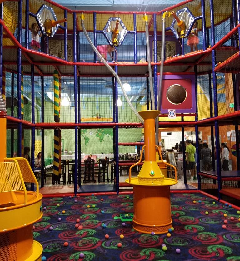
The three story foam ball projectile and climbing area at Kids World in Oak Park.