Vasquez Rocks Natural Area Park in Agua Dulce

The 932 acre Vasquez Rocks Natural Area Park, owned and managed by the County of Los Angeles, contains ancient rock sculptures created by 20 to 25 million years of earthquake movement along the Elkhorn Fault, an offshoot of the San Andreas Fault. The park is located in Agua Dulce off the Antelope Valley Freeway. Click the image below for more information.

Sandstone Peak to Inspiration Point and Tri Peaks in the Santa Monica Mountains

On everyone's local area bucket list should be the hike to the highest point in the Santa Monica Mountains - Sandstone Peak. That hike is about 3 miles round trip.

If you're looking to extend that hike, you can do the Mishe Mokwa Loop trail in reverse. Or you can explore several other peaks not far away - Inspiration Point and Tri Peaks. Hiking to Tri Peaks and back is about 6 miles round trip from the Sandstone Peak parking area.

Just north of the Sandstone Peak staircase/final ascent is a sign that indicates the trail to Tri Peaks. The trail is clearly marked and about 3/4 of a mile west you will come to the Inspiration Point spur trail. Do check it out as frankly I think the views towards the ocean are better here than at Sandstone Peak. Inspiration Point is 2,766 feet in elevation.

Follow the trail towards Tri Peaks from Sandstone Peak.

Follow the trail towards Tri Peaks from Sandstone Peak.

Sign on the Backbone Trail towards Tri Peaks signifying you are at the Inspiration Point spur trail. Sign indicates 2,800 ft elevation though I've read it is actually 2,766 ft. Close enough.

Sign on the Backbone Trail towards Tri Peaks signifying you are at the Inspiration Point spur trail. Sign indicates 2,800 ft elevation though I've read it is actually 2,766 ft. Close enough.

The view from Inspiration Point towards the ocean. The road below is Yerba Buena.

The view from Inspiration Point towards the ocean. The road below is Yerba Buena.

Inspiration Point dedication sign to an Eagle Scout who lost his life much too early.

Inspiration Point dedication sign to an Eagle Scout who lost his life much too early.

Another 3/4 mile or so of hiking gets you to Tri Peaks, which is 3,010 ft elevation, not too far behind Sandstone Peak. Tri Peaks is northeast of Inspiration Point and there are a number of signs that tell you you are getting close. The final sign before reaching Tri Peaks says you are .2 miles away. But after that, to my knowledge there is no official sign that says you have reached Tri Peaks. The final 1/2 mile spur trail to Tri Peaks is much more narrow than the main trail.

You have reached your destination - Tri Peaks.

You have reached your destination - Tri Peaks.

Personally when I went I was alone and in running shorts and t-shirt. Had I been wearing more appropriate hiking gear and long pants, I would have explored the peaks and caves a bit but without being properly equipped I opted to stay safe. But on the west side you can get some pretty sweet views of the Santa Monica Mountains towards Point Mugu and beyond.

Also, be careful to pay attention to the trail you came in from. There is no signage indicating the trail back, and the trail is not particularly clearly marked. 

View towards the Oxnard Plain from Tri Peaks.

View towards the Oxnard Plain from Tri Peaks.

Arsenal Comics & Games in Newbury Park

ArsenalComics.jpg

Arsenal Comics & Games opened its doors on September 23, 2014 and is located at 2333 Michael Drive, Newbury Park. The store serves Ventura County with comics, tabletop games, magic tournaments, Pokemon, video games and more.

I love this store because it provides such a unique array of vintage and new comics that are so fun to look at and, for many collect. 

Boardgaming 1pm to close on Sundays. Friday night magic. And other fun weekly activities.

Visit arsenalcomicsandgames.com or call 805.499.6197 for more info. Open daily 11am to 8pm.

StarCity_1.jpg
StarCity_2.jpg

Ojai Library Ukulele Club

The Ojai Library Ukulele Club meets every Wednesday from 6 to 7 p.m. in the main library building. The Ukulele Club is about sharing the fun, simplicity, and musicality that the ukulele offers, and learning and practicing with other players. Continuously meeting since its formation in 2015, the club is open to all ages and levels of experience. If you have your own ukulele, bring it along! Alternatively, the club has a couple of extra ukuleles for drop-in guests to try out for the evening.

Feel free to bring a copy of a song or tune that you like; the club collects these in a book of songs used during meetings. Currently this collection includes classic ukulele standards, American folk music, contemporary selections, and more. Each songbook includes a chord chart and is easy to follow—each song has the accompanying chords and lyrics listed and ready to play!

These events are free and open to the public. For additional information, contact Ron Solórzano, Regional Librarian, at (805) 218-9146.

The Ojai Library is located at 111 East Ojai Avenue in Ojai. Hours of service are 10 a.m. to 8 p.m. Monday through Thursday and 12 p.m. to 5 p.m. Friday through Sunday.

The Ventura County Library is available 24/7 at www.vencolibrary.org.

Heritage Square Oxnard - Historic Tours

HeritageSquare.png

Visit Heritage Square in Oxnard for an information-filled tour of the historic structures of Heritage Square and learn more about Oxnard. Docent led tours are $5, $10 for a family of four. Every Saturday 10AM - 4PM and every Sunday 1PM - 4PM, weather permitting. School and group tours available by appointment. The tours are approximately 45 minutes long and include 3 interiors and 8 exteriors of the 15 structures on this block. Tours start at the Heritage Square Visitor Center at 715 South A Street, next to the water tower.

More information at www.heritagesquareoxnard.com or call 805.483.7960.

Santa Barbara Historical Museum

SantaBarbaraHistoricalMuseum.jpg

Founded in 1932, the Santa Barbara Historical Museum houses a collection of over 80,000 objects and artifacts of significance relating to Santa Barbara’s past. Constructed in 1965 by the Santa Barbara Historical Society, the Museum is the primary repository of Santa Barbara’s collective cultural heritage and ethnic diversity. Visitor see a wide array of unique paintings, objects, photographs, furnishings and textiles dating from the 15th century. Santa Barbara’s rich past is represented with artifacts from Chumash, Spanish, Mexican, “Yankee” and Chinese cultures. The Museum also hosts three to four special exhibitions a year in the rotating Sala gallery.

The Gledhill Library contains rare literary and visual documents, including 70,000 historic photographs. Two early 19th century buildings, the 1817 Casa Covarrubias and the 1836 Historic Adobe are adjacent to the Museum.

The Fernald Mansion, a fourteen room Queen Anne Victorian located at 414 West Montecito Street, is currently closed for renovation.

Admission is free, $5 donation suggested. The Museum is open Tuesday to Saturday from 10am-5pm, Sunday 12-5pm, and is closed Mondays. Free guided tours on Saturdays and Sundays at 2pm.

The Museum is located at 136 E. De la Guerra Street, on the corner of Santa Barbara St. and De la Guerra. Visit www.SantaBarbaraMuseum.com or call 805.966.1601 to learn more.

Noah's Ark at the Skirball Center

Noah's Ark Exhibit at Skirball Center

Noah's Ark at the Skirball is a can't miss excursion for your kids.  It is an 8,000 square foot permanent exhibit with a huge ark and numerous interactive exhibits involving the various animals on the ark.  While roughly based on the biblical story of Noah's Ark, the exhibit is nondenominational and is an interactive learning and fun experience.  I would say that generally kids between the ages of 2 and 7 will enjoy this exhibit the most but kids and adults of all ages enjoy this amazing display of life-size giraffes, camels and uniquely displays. 

Noah's Ark Picture #2

If you plan to attend, reserve a space in advance as they limit the crowds to manageable quantities (which is good because it gives the kids more space to explore).  This is a beautiful museum off the 405 freeway going down the Sepulveda Pass, off at Skirball Center Drive, roughly 25 miles from Thousand Oaks.

More information from the www.skirball.org website:

Imagine yourself immersed in a favorite childhood tale. Five years in the making and occupying an 8,000-square-foot gallery, Noah's Ark at the Skirball welcomes children and families to take this journey together. Inspired by the ancient flood story, which has parallels in diverse cultures around the world, this one-of-a-kind new destination invites visitors of all generations to have fun—and to connect with one another, learn the value of community, and help build a better world.

The galleries are divided into three distinct and lively zones embodying the central themes of the Noah's Ark story:

  • Storms (meeting challenges)
  • Arks (finding shelter and community)
  • Rainbows (creating a more hopeful world)

Inside a floor-to-ceiling wooden ark, filled to the rafters with whimsical animals, you and your family will play, build, climb, explore, collaborate, and more. Conduct a storm, help construct the ark, and bask in the glow of a beautiful rainbow. Mingle with hundreds of fanciful animals—from cuddly companions to life–sized puppets—all crafted from recycled materials and everyday objects, including bottle caps, bicycle parts, baseball mitts, croquet balls, mop heads, and rear-view mirrors.

The Skirball is open Tuesday through Sunday (closed Mondays and certain holidays). Museum admission is $12. $9 for 65+, full-time students with ID and children over 12.  $7 for ages 2-12. FREE admission to all on Thursdays.

Upper Sycamore Canyon Trail in Point Mugu State Park

The Upper Sycamore Canyon Trail is a 1.3 mile trail connects to the bottom of steep Sycamore Canyon Fire Road on the west to the Danielson Road trail on the east.

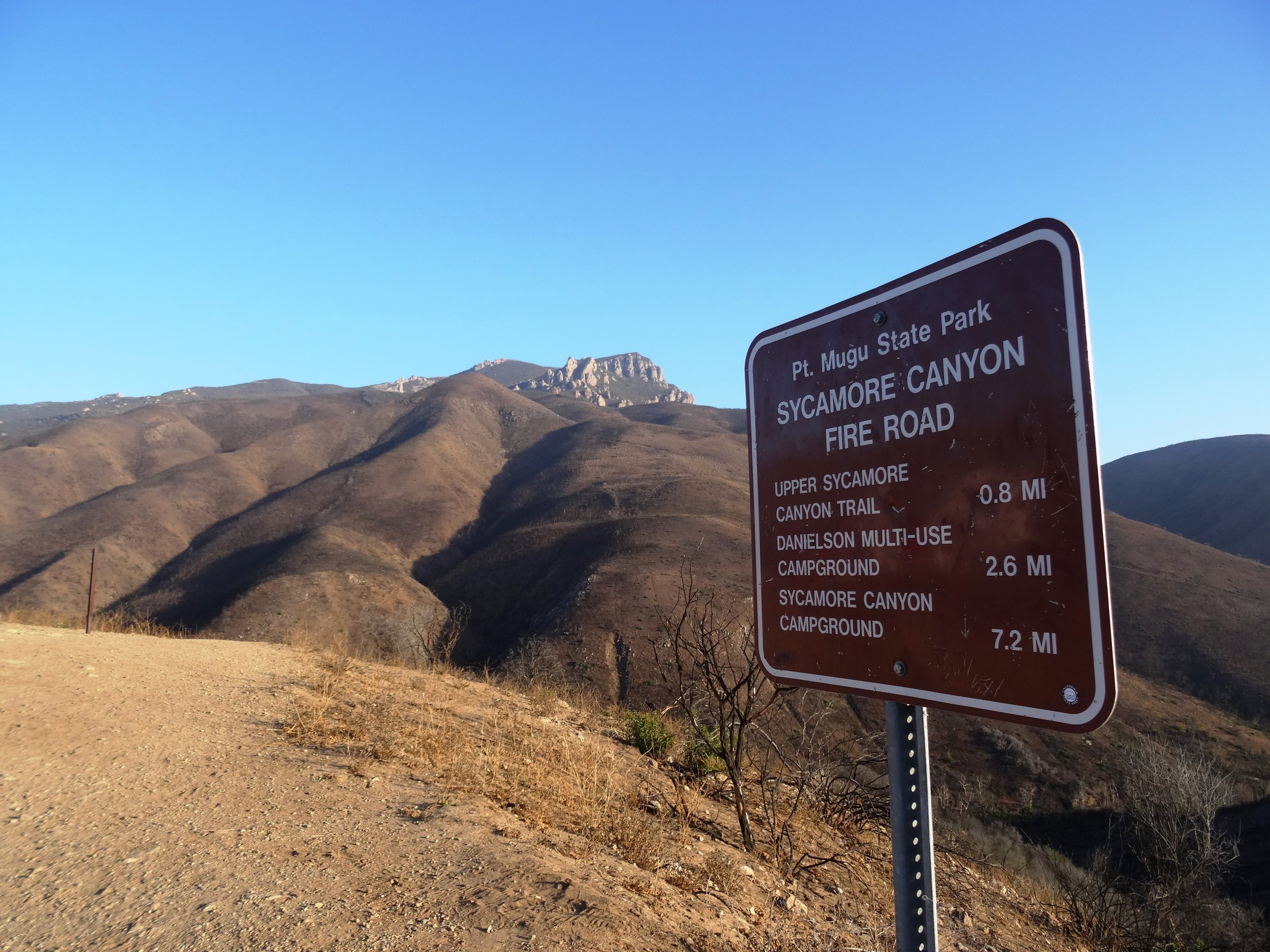
Sign at top of Sycamore Canyon Road before the descent into the canyon.

Sign at top of Sycamore Canyon Road before the descent into the canyon.

The trail goes deep into the canyon and can get quite overgrown, especially after solid winter rains. But it is an interesting hike and alternative to other trails that take you to "The Waterfall" in the Boney Mountain Wilderness. Bike and dogs are not allowed on these back country trails. Watch out of course for poison oak and snakes.

The "Narrow Bridge" sign marks the bottom of the steep initial grade down Sycamore Canyon Fire Road. You'll cross the bridge, then see the Upper Sycamore Canyon Trail entry to the left.

The "Narrow Bridge" sign marks the bottom of the steep initial grade down Sycamore Canyon Fire Road. You'll cross the bridge, then see the Upper Sycamore Canyon Trail entry to the left.

After you enter the west end of the Upper Sycamore Canyon Trail, within about a 1/10th of a mile is the entry point to the Fossil Trail, a very steep trail that leads up to the Old Boney Trail. 

Inside the canyon, looking west, towards the Sycamore Canyon Fire Road.

Inside the canyon, looking west, towards the Sycamore Canyon Fire Road.

After the substantial rains of Winter 2017, a creek has been flowing through this canyon and has caused some obstacles and overgrown sections of the trail. Do wear good hiking shoes.

Upper Sycamore Canyon Trail (Map excerpt courtesy of National Park Service)

Upper Sycamore Canyon Trail (Map excerpt courtesy of National Park Service)

Danielson Road sign you will see at the east end of Upper Sycamore Canyon Trail, Now you can head back up towards Rancho Sierra Vista/Satwiwa to the left or go the The Waterfall and/or Danielson Monument.

Danielson Road sign you will see at the east end of Upper Sycamore Canyon Trail, Now you can head back up towards Rancho Sierra Vista/Satwiwa to the left or go the The Waterfall and/or Danielson Monument.

Ventura River Trail

VenturaRiverTrail.jpg

The Ventura River Trail is a 6.3 mile asphalt pedestrian and bike path that follows the old Southern Pacific Railroad right-of-way from Main Street in Ventura to Foster Park inland towards Ojai. The path, originally opened in 1999, connects the Ojai Valley Trail to the Omer Rains Trail along the beachfront for 17 miles of great bicycling. The trail is open dawn to dusk.

Much of the Ventura River Trail parallels Ojai Freeway 33 and as such is also referred to as the Ojai Valley Trail Extension. Here are the various access points from south to north:

OK, so now for some commentary. This is not exactly the most exciting bike path in the world. You are paralleling Highway 33 and are kind of off the beaten path in an industrial area, but it is a peaceful path. Also, there are several stops you need to make as you cross streets, so your kids (and you) do need to be aware of that. You won't find an ocean view on this path.  But...it is never crowded, quite flat and a great way to get out on the bikes away, for the most part, from automobiles.

One of the more interesting, albeit somewhat creepy scenes along the path is this dormant USA Petroleum Refinery that was closed in 1984 after operating less than 10 years.  A bit of an eyesore this 96 acre, barbed wire fence enclosed section on the north end of the trail is. In the past there have been homeless encampments in the vicinity, but I've never seen them.

USAPetrol_view1.JPG
USAPetrol2.JPG
USAPetrol4.JPG

What I like to do is park in the free city parking lot near the Omer Rains Trail at the corner of W. Main St and Peking St, then take Main St a block east to N. Olive St, turn left (north) to Rex St. Take a left on Rex to the bike path entrance.

VenturaTrailEntry.JPG
VenturaTrailHwy33.JPG

Oakbrook Neighborhood Park in Thousand Oaks

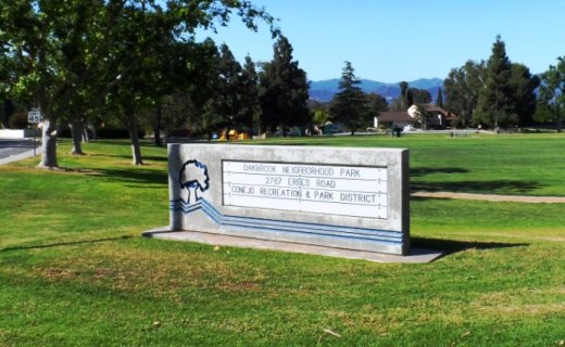
Located at the corner of Erbes Road and Pederson Road in Thousand Oaks, the 14 acre Oakbrook Neighborhood Park was expanded dramatically in 2012. The original park included a play area, sand volleyball court and large grassy area. The expansion includes a decent-sized parking area, small restroom, basketball and netball* courts, a jogging/walking/bike path and a nice horseshoe pit area. Visit the Conejo Recreation and Park District website at www.crpd.org for more information.

OakbrookParkTOsign.JPG
OakbrookParkGrassPlayArea.JPG
OakbrookParkPath.JPG
OakbrookParkHorseshoes.JPG

This is the original section of the park; primarily expansive grassy area with play area in background.Paved path area in the expanded section of the park.Something you don't see too often these days...new horseshoe pit area .

Yes, this is a netball court, not to be confused with a basketball court!

Yes, this is a netball court, not to be confused with a basketball court!

To learn more about the game of netball, click this link. This is the first, and, as of May 2013, only netball court in Thousand Oaks. And yes, I was confused when I saw it too.

Rose Valley Campground in the Los Padres National Forest in Ojai

Rose Valley Campground in Ojai is located at an elevation of 3,450 feet. It is open year-round. There are nine campsites located in a single loop, each with tables, BBQ grills, and/or fire rings. There is one vault toilet in the campground and another across from the lake. Drinking water is not available, so be sure to bring your own.

No reservations taken; first come, first served. An Adventure Pass is required to be displayed on car ($5/day or $30/year as of March 2017).

Half a mile hike gets you to the Rose Valley Falls. The trail begins at the southwest section of the campground.

Directions: Take Highway 33 north from Ojai 14.7 miles to mile marker 25.84.  Turn right at the Rose Valley Road turnoff and follow the paved road for 3.1 miles. Turn right again at the Rose Valley sign and drive 0.6 miles into the campground.

OTHER LOCAL CAMPING OPTIONS IN AND AROUND VENTURA COUNTY