Channel Islands Sportfishing Center

Ciscos.jpg

Channel Islands Sportfishing Center (aka Cisco's) is located at the Channel Islands Harbor at 4151 S. Victoria Avenue, Oxnard. Cisco’s has a fleet of 11 boats (as of February 2020) and operates 7 days a week.

Enjoy 1/2 day, 3/4 day, full day, overnight and two day trips. The Speed Twin is a nice foray into sportfishing for newbies - a half day trip on a boat with a capacity of 75 people. it departs at 8 am and returns at 4pm. You can bring your own fishing rods or rent them for $15 at the landing. You’ll also need a one day fishing license that you can buy there.

Visit www.channelislandssportfishing.com or call 805.382.1612 to learn more and to book your next fishing trip.

CiscosSpeedTwinCV.jpg

Sandstone Peak Hike in Malibu

Views from Sandstone Peak trail towards Lake Sherwood.

Views from Sandstone Peak trail towards Lake Sherwood.

Sandstone Peak is the highest point in the Santa Monica Mountains at an elevation of 3,111 feet. Views from the trail stretch from the Pacific Ocean and Channel Islands and inland to the Conejo/Simi Valleys.

From the Conejo Valley, take Westlake Boulevard south until it becomes Decker Canyon, make a right on Mulholland, then right on Little Sycamore Road, which becomes Yerba Buena Road, with an endpoint of Sandstone Peak Trailhead. Before you see this sign on the right, you will be passing a parking lot at the Mishe Mokwa Trailhead. Another .6 miles and you'll see the sign below.

The hike is only about 3 miles round trip. Depending on how fast you go, the 1.5 mile climb to the top can take anywhere from 25 minutes to an hour. The trail is well maintained but has quite a bit of loose stones, so be sure to wear good shoes so you don't twist an ankle. The starting elevation at the Sandstone Peak trailhead is 2,030 feet, so you'll be climbing over 1,000 vertical feet over 1.5 miles.

Visit the National Park Service website at www.nps.gov/samo/planyourvisit/circlexranch.htm for more information about the Circle X Ranch area and a printable pdf map of the trails that will get you to Sandstone Peak, including the Mishe Mokwa Trail, Grotto Trail and the Backbone Trail.

To extend the hike, check out Sandstone Peak to Inspiration Point and Tri Peaks.

There are several ways of getting to Sandstone Peak. The most direct way is the trailhead directly up to Sandstone Peak (takes about an hour) and the other is via the Mishe Mokwa Trail, which takes you to Split Rock, through a loop that connects you to the Backbone Trail to Sandstone Peak. This trail will give you views of "Balanced Rock" that you'll see pictured below. Once you reach Sandstone, you'll find a steep staircase that will take you to the peak.

Sandstone0.1.jpg
Balanced Rock

Balanced Rock

Balanced Rock from another angle.

Balanced Rock from another angle.

Sandstone7.jpg
Sandstone10.jpg
Prior to the Woolsey Fire of November 2018, this sign and staircase marked the final ascent to the peak. They were destroyed in the fire, however, and a new path was constructed . See photo below.

Prior to the Woolsey Fire of November 2018, this sign and staircase marked the final ascent to the peak. They were destroyed in the fire, however, and a new path was constructed . See photo below.

New path leading to final ascent to the top after Woolsey Fire.

New path leading to final ascent to the top after Woolsey Fire.

The unofficial name bestowed on Sandstone Peak by the Boy Scouts is "Mt Allen," named in honor of W. Herbert Allen to commemorate his gift of this mountain to the Boys Scouts of America in 1965.

The unofficial name bestowed on Sandstone Peak by the Boy Scouts is "Mt Allen," named in honor of W. Herbert Allen to commemorate his gift of this mountain to the Boys Scouts of America in 1965.

Sandstone2.jpg

Channel Islands Boat Rides - Island Packers

island packers logo.jpg

Since 1968, Island Packers has provided reliable, enjoyable transportation between the Ventura/Oxnard Harbors and the Channel Islands National Park & Marine Sanctuary.

Island Packers has scheduled trips departing out of the Ventura and Oxnard Harbors and is the only exclusive boat concessionaire with authorization to transport guests to the Channel Islands National Park. Three 149-capacity catamarans and one 81-passenger mono hull vessel provide half and whole day trips year round to the Anacapa and Santa Cruz Islands, with trips to the Santa Barbara, Santa Rosa and San Miguel Islands from mid-April through the fall months.

On a personal note, we've been on Islands Packers boats a number of times and they are a class act. Great service and responsiveness.

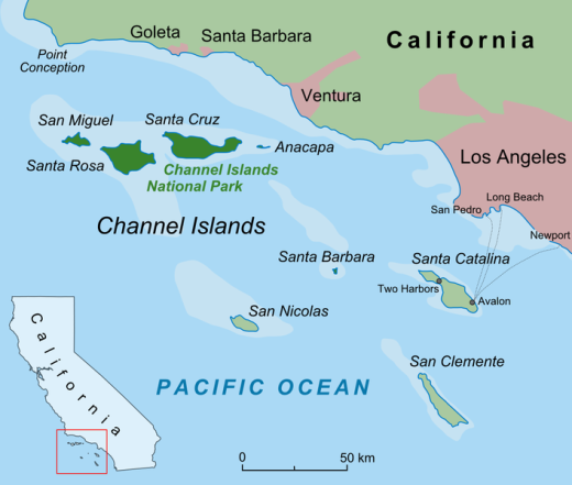
Marine Wildlife Cruises (which do not land on the island) depart from the Harbor for 3 hour narrated cruises along the shores of Anacapa or Santa Cruz Island within the Channel Islands Marine Sanctuary. Highlights include sightings of sea lions, harbor seals and marine bird life, along with the opportunity to view whales and dolphins during the channel crossing. Island Packers also offers whale watching cruises - which, depending on the time of year, are a once in a lifetime opportunity to see some of the Pacific's most magnificent creatures. While pods of dolphins can be seen nearly year-round, whales are a far more seasonal bunch:

  • Late December-Mid April: Gray whales

  • April-September: Humpback and Minke whales

  • Summer & Fall: Giant Blue whales- not only the earth's largest mammal, but thought to be the largest known animal ever to have existed.

Whales aren't all these cruises have to offer, however. A trip to the Channel Islands can also mean sightings of rare birds! Though difficult, pelagic birding can be incredibly rewarding - but the real treasure trove is on the Islands themselves.

Santa Cruz Island is also home to the gem of the Channel Islands birding community - the Island Scrub-jay! The Island is the only place in the world this bird is found, and is highly sought after for avid bird enthusiast's 'life lists.'

For schedules, directions, tickets and more information, visit www.islandpackers.com, or call (805) 642-1393. Open 9:00 a.m. to 5:00 p.m. daily.

Island Packers has two locations:  Ventura Harbor, 1691 Spinnaker Drive, Suite 105B, Ventura and Channel Islands Harbor, 3600 S. Harbor Boulevard, Oxnard.

IslandPackersVenturaHarbor.JPG

Lynnmere Trail in Thousand Oaks

The Lynnmere Open Space contains 4 to 5 miles of ridgeline trails in 114 acres in the area south of Wildwood Park and west of Lynn Road in Thousand Oaks.  Awesome views of Wildwood Park, Mount Clef Ridge and the Conejo Canyons Open Space.

Views from Lynnmere Trail looking north towards Wildwood Park and Mount Clef Ridge.

Views from Lynnmere Trail looking north towards Wildwood Park and Mount Clef Ridge.

As you can see in the map below (provide courtesy of the Conejo Open Space Foundation), you can actually hike a nice loop on the Lynnmere Trail and connect to other trails in the area.

ArroyoLynnmereLoop_cosf.gif

There are a number of places where you can enter the Lynnmere Trail, including:

The hike outlined in the image above is the fairly strenuous, seven mile Arroyo Conejo/Lynnmere Loop hike described at www.cosf.org/website/html/arroyo-conejo-lynnmere.html. Park at the Rancho Conejo Playfield at 950 N. Ventu Park Road and the Arroyo Conejo trailhead is on the right.

RanchoConejoPlayfield_sign.JPG

After about a mile and a half of rolling hills, there's a descent into the canyon. You'll come across the creek at the bottom, where you'll find a foot path. Soon after crossing the path, you'll find a sharp right (unmarked to my knowledge) turn up the barranca to the Lynnmere Trail, and you're on your way.

ArroyoConejo_stream1.JPG
You may come across this bench at the peak of the southern section of Lynnmere Trail.

You may come across this bench at the peak of the southern section of Lynnmere Trail.

After the winter rains it greens up nicely here and other Conejo Valley trails.

After the winter rains it greens up nicely here and other Conejo Valley trails.

El Pescador Beach in Malibu

El Pescador Beach ("The Fisherman") has the distinction of being the closest beach in terms of auto mileage from central Thousand Oaks, located at 32900 Pacific Coast Highway, just east of the intersection of Decker Canyon Road and PCH. Along with La Piedra Beach and El Matador Beach, El Pescador is part of the Robert H. Meyer Memorial State Beach. 

El Pescador Beach is located about 2 1/2 miles east of Leo Carrillo State Beach and 5 miles west of Zuma Beach. Along with the other two beaches, El Pescador has a parking area (for a fee) and a porta-john. Dogs are not allowed on state beaches. There is also limited parking on PCH available, but be sure to look at the signs to make sure you don't park in a "no parking" zone.

Steep, uneven stairs lead you to the beach. Not particularly stroller friendly as a result, but it's not that far to go. This beach never seems to be crowded, which is a good thing.

You can explore trek over to La Piedra Beach from here, at least when the tide is not too high.

Bottom half of the steps from the parking lot to El Pescador Beach.

Bottom half of the steps from the parking lot to El Pescador Beach.

Public Beach Access Between Sycamore Cove and County Line Beach in Malibu

Between Sycamore Cove Beach at 9000 Pacific Coast Highway, which is part of Point Mugu State Park, and County Line Beach, across the street from Neptune's Net and Yerba Buena Road at 42505 Pacific Coast Highway, there are three or four access points to the beach.

Look for the brown "Coastal Access" signs.

The first access point is just over a mile southeast of Sycamore Canyon at about 10302 Pacific Coast Highway. There is parking on PCH and an old staircase adjacent to a Call Box.

The not particularly well taken care of steps to the beach at (approximately) 10302 PCH.

The not particularly well taken care of steps to the beach at (approximately) 10302 PCH.

Another access point is another 1/2 mile east is at approximately 9999 Pacific Coast Highway, near the juncture of Deer Creek Road. You'll see another brown Coastal Access sign and blue Call Box. Park on PCH and look for the staircase. I call this 26 Steps Beach.

Staircase at 9999 Pacific Coast Highway

Staircase at 9999 Pacific Coast Highway

The final southeast stretch of PCH between the access point above and Neptune's Net has even less distinguishable areas, but you can pull over to the side and park over most of this stretch (except when there are No Parking signs). 

CLICK HERE FOR PUBLIC BEACHES STRETCHING FROM OXNARD TO MALIBU

Lake Piru Recreation Area

Lake Piru Recreation Area

The 60 acre Lake Piru Recreation Area is located on the western shore of Lake Piru, an artificial lake in the Los Padres National Forest. Lake Piru offers 238 tree-shaded campsites, coin-operated hot showers and a store. Each site has a picnic table, fire ring and grill top.

The dam is owned and operated by the United Water Conservation District of Santa Paula and a third party operates the campsite; visit campone.com/campsites/lake-piru for more information. Boat rentals and fishing available as well as a newer children's playground area.  Make camping reservations by calling 805.521.1500.

Lake Piru in Summer 2015

Ventura Raceway

VenturaRaceway.jpg

Ventura Raceway is a world-famous dirt track located at the Ventura County Fairgrounds.  Ventura Raceway became world famous in the early 1990s when it hosted several years of the ESPN Thunder Series on television. 

With weekly racing events held on most Saturday nights from March through October, Ventura Raceway has a worldwide following of short track racing fans.  Most Saturday nights you can find the powerful VRA 360 Sprint Cars racing at the 1/5 mile oval.  These 600+ horsepower, open wheel racers hit speeds in excess of 80 mph on the track that is smaller than a high school oval track. 

Beyond the sprint cars, there are classes for seniors (age 45 and up) down to kids as young as 5 years old in a family friendly environment. 

Located at 10 West Harbor Blvd, Ventura. Admission (as of January 2019) is $15 for adults, $11 for 60+, military and students with ID and free to 12 and under (with adult). Visit www.venturaraceway.com or call 805.648.RACE for more information.

Backbone Trail Hike From Kanan Road Trailhead to Zuma Ridge Motorway in Malibu

NOTE: Closed due to damage from the Woolsey Fire as of December 2018. Updates at www.nps.gov/samo/planyourvisit/backbonetrail.htm.

You've driven Kanan Road from Agoura Hills towards PCH for decades and have passed by the Backbone Trail trailhead on Kanan and Newton Canyon Road just before Tunnel "T-1" hundreds of times. But you never stopped there to check it out. Well, it's about time to give it a try!

The Backbone Trail stretches 67 miles through the Santa Monica Mountains, from Will Rogers State Park on the east to the Ray Miller Trailhead on the west. There are 12 "official" Backbone Trail trailheads and the Kanan Road Trailhead is one of them. More information on the National Park Service website at www.nps.gov/samo/planyourvisit/backbonetrail.htm.

There are two trailheads to catch here at what is also referred to as the Newton Canyon Trailhead. The Backbone Trail to the Latigo Canyon Trailhead is 2.5 miles one way headed east. The Backbone Trail to the Zuma Ridge Motorway - the one covered here - is also 2.5 miles one way headed west. 

The Backbone Trail to Zuma Ridge Motorway is a nice, moderate, winding, mostly single track, well-maintained trail. You'll encounter a creek, a view of the Upper Zuma Falls, a short bridge, some tree-lined canopied sections, wildflowers and moderately rocky sections.

KananBackboneTrail1.JPG

Once you reach Zuma Ridge Motorway, you can continue on the Backbone Trail or turn back for a five mile round trip hike.

Ranch Overlook Trail in Rancho Sierra Vista/Satwiwa in Newbury Park

Trailhead to the Ranch Overlook Trail starts at the juncture of Sycamore Canyon Fire Road (paved road that runs through Point Mugu State Park) and the access bridge to the Satwiwa Native American Culture Center.

Trailhead to the Ranch Overlook Trail starts at the juncture of Sycamore Canyon Fire Road (paved road that runs through Point Mugu State Park) and the access bridge to the Satwiwa Native American Culture Center.

This is the bridge heading the other direction from the Ranch Overlook Trail sign leading to the Satwiwa Native American Indian Culture Center.

This is the bridge heading the other direction from the Ranch Overlook Trail sign leading to the Satwiwa Native American Indian Culture Center.

The one mile Ranch Overlook Trail is located in Rancho Sierra Vista/Satwiwa in Newbury Park.

The trail extends from just west of the Satwiwa Native American Indian Culture Center to the Palomino Trail in the Rancho Potrero Open Space.

The trail is about two wide and you’ll find hikers, runners, cyclists and equestrians all sharing it. The east portion is moderately flat, leading to a moderate hill. At the peak, you’ll have nice views toward the Rancho Sierra Vista main parking area and adjacent ranch structures as well as towards Boney Mountain.

Continue west down the trail to a juncture where you can either veer right towards the parking area and road into Rancho Sierra Vista, or you can continue straight until the next juncture. At the next juncture, if you take a left, you’ll soon be transitioning from Federal land (Rancho Sierra Vista) to Conejo Open Space land (Rancho Potrero). Though you won’t find a trail sign that indicates this, the trail that continues westward is the Palomino Trail.

Do be mindful of rattlesnakes back here. They want nothing to do with you, so if you come across one crossing the trail, let them make their way across.

The “peak” of the Ranch Overlook Trail, looking southeast towards Satwiwa and Boney.

The “peak” of the Ranch Overlook Trail, looking southeast towards Satwiwa and Boney.

Peak of Ranch Overlook Trail, looking down towards main Rancho Sierra Vista/Satwiwa parking area and restrooms.

Peak of Ranch Overlook Trail, looking down towards main Rancho Sierra Vista/Satwiwa parking area and restrooms.

This is west of the peak of the Ranch Overlook Trail, a downhill section that takes you towards Rancho Potrero.

This is west of the peak of the Ranch Overlook Trail, a downhill section that takes you towards Rancho Potrero.

This sign is at the bottom of the west side of the Ranch Overlook Trail, facing east, if you opt to take the trail counter-clockwise from the parking area.

This sign is at the bottom of the west side of the Ranch Overlook Trail, facing east, if you opt to take the trail counter-clockwise from the parking area.

This ancient oak tree is adjacent to the Ranch Overlook Trail sign near the parking lot access. This was taken in September 2018. The large branch broke off earlier that summer. In the background is the parking area.

This ancient oak tree is adjacent to the Ranch Overlook Trail sign near the parking lot access. This was taken in September 2018. The large branch broke off earlier that summer. In the background is the parking area.

This is the Palomino Trail in the adjacent Rancho Potrero Open Space, looking east towards Rancho Sierra Vista, in June 2018. These areas do green up after the winter rains in the April/May time frame….but dry up fast.

This is the Palomino Trail in the adjacent Rancho Potrero Open Space, looking east towards Rancho Sierra Vista, in June 2018. These areas do green up after the winter rains in the April/May time frame….but dry up fast.

Channel Islands National Park

Channel Islands National Park consists of 5 of the 8 Channel Islands off the Santa Barbara coast. Although the islands are close to the shore, their isolation has left them relatively undeveloped.

The northern Channel Islands are Anacapa (1.1 sq mi), San Miguel (14.6 sq mi), Santa Cruz (96.5 sq mi) and Santa Rosa (83 sq mi) and the southern islands are San Clemente (57 sq mi), San Nicolas (23 sq mi), Santa Barbara (1 sq mi) and Santa Catalina (75 sq mi).

Channel Islands National Park includes the islands of San Miguel, Santa Rosa, Santa Cruz, Anacapa and Santa Barbara. Anacapa is located in Ventura County while the other four are in Santa Barbara County. San Clemente Island, the southernmost Channel Island, is owned and operated by the U.S. Navy. Catalina Island as we know with its population of 3,700 is a popular tourist destination. San Nicolas Island in Ventura County is also controlled by the U.S. Navy. On a clear day you can see two of the five islands, Anacapa and Santa Cruz.

ChannelIslandsMap.jpg

Visitors to the islands may swim, snorkel, hike, camp, watch wildlife, sail and explore tidepools, beaches and canyons. There is no food service on the islands, so bring what you need. Take a commercial service to the islands like Island Packers, which has been servicing the islands since 1968. Landings at Anacapa and Santa Cruz islands are year-round while the more remote outer islands, Santa Barbara, Santa Rosa and San Miguel are scheduled late spring through early fall.

Visit the National Park Service website at www.nps.gov/chis to learn more about visiting Channel Islands National Park. The park is open year-round.

The Robert J. Lagomarsino Visitor Center at Channel Islands National Park is located in the Ventura Harbor at 1901 Spinnaker Drive (805.658.5730) and the Outdoors Santa Barbara Visitor Center is located at the Santa Barbara Harbor at 113 Harbor Way, 4th Floor.

On a clear day you can see two of the Channel Islands from Newbury Park and other Ventura County spots. Here's a view from the Rancho Potrero Open Space in Newbury Park.

On a clear day you can see two of the Channel Islands from Newbury Park and other Ventura County spots. Here's a view from the Rancho Potrero Open Space in Newbury Park.

Anacapa Island seen from a whale watching boat.

Anacapa Island seen from a whale watching boat.

Old Boney Trail Hike in Pt. Mugu State Park

If you're looking for a hike of about 10 miles in the Rancho Sierra Vista/Boney Mountain Wilderness area, consider the Old Boney Trail loop from Newbury Park. You can park either in the National Park Service parking lot or at Wendy Drive where it meets Potrero Road.

You can do the hike clockwise or counter-clockwise since it is a loop course. I prefer clockwise, which starts by trekking through Rancho Sierra Vista to Danielson Road. Details of this path are at THIS LINK. This path gets you to a juncture where you can continue another 3/10ths of a mile to the Danielson Monument (which you definitely should do if you've never been there) or veer a sharp right up the Old Boney Trail.

Sign at juncture of Danielson Road trail and Old Boney Trail in Pt. Mugu State Park

Sign at juncture of Danielson Road trail and Old Boney Trail in Pt. Mugu State Park

I love the Old Boney Trail. It is narrow and covered with growth on both sides. Kind of like running through a chaparral jungle. This makes the trail mostly shade covered for the first couple miles of this 3.5 mile stretch of trail. You'll be treated to some nice views of Boney Mountain along the way.

OldBoneyTrail1.JPG

Although the Old Boney Trail does not reach a peak for panoramic views, you'll still find several spots that reward you with views towards the Channel Islands and west Ventura County.

OldBoneyTrail2.jpg

About a mile or mile and a half into Old Boney Trail from Danielson Road, you'll see a turnoff sign to the right that takes you to the Fossil Trail, a mile or so drop back down to the bottom of Sycamore Canyon. The drop is about 1300 ft to 500 ft with plenty of rocky surfaces, so you'll have some fun going back down this way, for a shorter route. And of course, look closely and you'll be treated to surfaces covered with sea fossil imprints from millions of years ago.

OldBoneyFossilTrailSign.JPG

From the Old Boney Trail/Fossil Trail juncture, you have another 2.1 fun miles to the next juncture at Blue Canyon Trail at the bottom of the canyon. You'll get some more neat views of Boney Mountain during this stretch. At the juncture is the following sign on Blue Canyon Trail.

Sign on Blue Canyon Trail at the Old Boney Trail juncture in Pt. Mugu State Park.

Sign on Blue Canyon Trail at the Old Boney Trail juncture in Pt. Mugu State Park.

You will turn right on Blue Canyon Trail, which will take you to the Danielson Multi-Use area and the paved Sycamore Canyon Fire Road. A left-hand turn will get you lots of fun for another day, onward to Chamberlain Trail that gets you up to some might nice peaks, and Serrano Valley.

Sign at entrance to Blue Canyon Trail at the Danielson Multi-Use area (you of course will be looking at the back side of this sign if you're coming from the Old Boney Trail).

Sign at entrance to Blue Canyon Trail at the Danielson Multi-Use area (you of course will be looking at the back side of this sign if you're coming from the Old Boney Trail).

I've never actually seen anyone using the Danielson Multi-Use area but here's the picnic area.

I've never actually seen anyone using the Danielson Multi-Use area but here's the picnic area.

So you run through the Danielson area to the main paved road to the right (turning left of course will take you to PCH in about 4-5 miles). In another 3 miles you'll be back in civilization; these miles include the 800 foot, 3/4 mile ascent into Rancho Sierra Vista, which can be a bit brutal...perhaps my (and maybe your) least favorite section of this course. But once you're up the hill, you're home free! Time for breakfast, lunch, dinner or all of the above!

Sycamore Canyon Fire Road sign at the top of the hill in Rancho Sierra Vista/Satwiwa.

Sycamore Canyon Fire Road sign at the top of the hill in Rancho Sierra Vista/Satwiwa.

Of course, you can easily reverse this course and make your way DOWN Sycamore Canyon Fire Road, turn left onto Blue Canyon Trail, left on Old Boney Trail for 3.5 miles and then left on Danielson Road, back down into the canyon and up towards Satwiwa.

Oak Park Campground in Simi Valley

OakParkCampground.jpg

Located at 901 Quimisa Drive in Simi Valley, the Oak Park Campground is a rustic 100.5 acre open space park that is surrounded by gentle, rolling hills and an abundance of coastal sage scrub brush. This natural environment supports a multitude of California native wildlife species, such as a raptors, roadrunners, sagebrush lizards, and alligator lizards. The park is ideal for group RV camping in a secluded setting.

Day use is $2 per day ($4 on weekends) (as of July 2018). Camping is $32 per day.

Plenty of things to explore in this 100 acre space! Learn more or make reservations at www.ventura.org/inland-parks/oak-park-simi-valley or call 805.654.3951.

The video shot below was on a Sunday night around 7 p.m. in July 2010. There was for the most part nobody there! What a great opportunity to camp with your kids locally! I guess my only concerns about the location would be that the park is sandwiched between the 118 freeway and the railroad tracks...though I did not encounter any noise issues in my brief drive-by.