Malibu Creek State Park

MalibuCreekSP_sign.JPG

Malibu Creek State Park is accessible in Calabasas, at 1925 Las Virgenes Road, south of Mulholland. The park contains over 4,000 acres of rugged, beautiful hills, trails and scenery. It stretches from Agoura Hills down to Malibu, down to Malibu Lagoon State Beach, covering much of the 25 mile Malibu Creek that flows from Boney Mountain down to the Lagoon. Malibu Creek is the only stream channel that crosses through the Santa Monica Mountain range.

There are three natural preserves in the park, Liberty Canyon, Udell Gorge and Kaslow, which protect Valley Oaks, rare plants and volcanic formations.

Things to do in Malibu Creek State Park include hiking, running, biking, camping, picnicking, fishing and checking out the wildlife. There are over 35 miles of trails and fire roads throughout the park. A fun added bonus is the old M*A*S*H series set, filmed from 1972 to 1983, that resides there.

Dogs are not allowed in Malibu Creek State Park trails.

Malibu Creek State Park contains roughly three dozen different trails, many easy, and some...extraordinarily challenging, such as the Bulldog trail, taking you to 2,500 foot peaks with panoramic views out to the ocean and surrounding peaks and valleys.

Parking for the day at Malibu Creek State Park is currently $12, or $3 per hour. You can also park at the corner of Mulholland and Las Virgenes and make your way into the park via the Grassland Trail.

The campground at Malibu Creek State Park has 62 campsites and 4 RV sites. Visit www.parks.ca.gov/?page_id=614 for more information.

The old M*A*S*H site is 2.7 miles from the parking area.
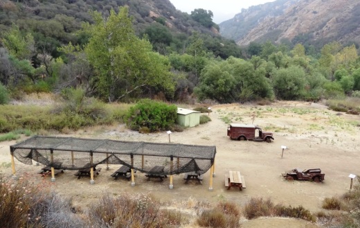
M*A*S*H site with plenty of picnic tables
M*A*S*H site with plenty of picnic tables

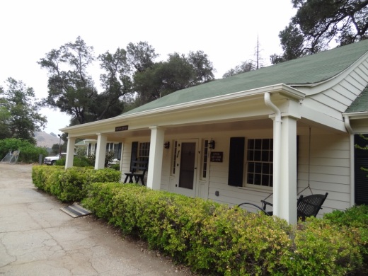
The Visitor Center is only a 10 minute walk from the parking lot and is generally open from noon to 4pm on weekends.

The Visitor Center is only a 10 minute walk from the parking lot and is generally open from noon to 4pm on weekends.

There's also an interesting visitor center about 1/2 mile from the main entrance to the park. It is open on Saturday/Sunday from noon to 4pm, subject to availability of docents. Worth a stop as there are some neat things to see in there, including wildlife and rocks/artifacts and other useful information. You can also purchase drinks in there as well as a small assortment of other items.
Hike to the Rock Pool at Malibu Creek State Park

Century Lake Hike at Malibu Creek State Park

Two Springs Trail and Wildwood Canyon Trails in Wildwood Park, Thousand Oaks

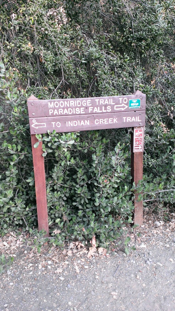
Sign on the west side of the Wildwood Park parking lot after walking down some steps

Sign on the west side of the Wildwood Park parking lot after walking down some steps. (Indian Creek Trail was renamed Two Springs Trail in May 2022.**)

If you enjoy the sound of running water, the Two Springs Trail (formerly Indian Creek Trail) and Wildwood Canyon Trail at Wildwood Park in Thousand Oaks are for you.

The Two Springs Trail can be accessed from the main Wildwood Canyon trailhead area parking lot at the east end of Avenida de los Arboles as well as at a separate trailhead on Arboles, slightly west of the parking lot.

Indian Creek Trail entry point from Avenida de los Arboles

Two Springs Trail (formerly Indian Creek Trail) entry point from Avenida de los Arboles

There are shady sections hidden among the trees and sections in the sun. Most of the trail runs along a creek that flows into Paradise Falls. This is not a completely easy hike as there are some hilly sections, a number of steps, and a stream crossing. That said, there's enough variety to make this a fun and interesting hike with the kids.

Visit the Conejo Open Space Foundation website at cosf.org/trails/wildwood/wildwood-park-easy-hike-moonridge-trail/ for a handy map of these trails.

About half a mile or so into the hike, you'll come across a fairly significant waterfall down below, way below, in the creek. Not as large as Paradise Falls, but definitely prominent. Adjacent to that area is a bench. And from there you have some steps and a stream crossing to make it down to the flatter section of the trail.

The waterfall seen from the Indian Creek Trail. Be careful!

The waterfall seen from the Two Springs Trail (formerly Indian Creek Trail). Be careful!

The bench on the Indian Creek Trail in Wildwood Park

The bench on the Two Springs Trail (formerly Indian Creek Trail) in Wildwood Park

Eventually you get to a bridge. If instead of crossing the bridge, you veer left (southwest), you'll be on the Wildwood Canyon Trail along the creek. This is a wide path that can take you on another little sidetrack loop up the Castillo Trail to Castillo Circle (street). A bit of a steep, roughly 3/8ths of a mile trail to Castillo Circle, where you can walk back to a separate trailhead via Velarde Drive north to San Miguel Circle to the San Miguel Trail. You'll end up back at the bridge area.

The Wildwood Canyon Trail is pretty cool. Fairly flat, wide and runs along a creek. The water they say is mostly urban runoff but fun to check out up close with the kids.

The Wildwood Canyon Trail is pretty cool. Fairly flat, wide and runs along a creek. The water they say is mostly urban runoff but fun to check out up close with the kids.

The Meadows Center next to the bridge has restrooms and a drinking fountain. The Conejo Rec & Park District leads many hikes here for s'mores and fun activities.

The Meadows Center next to the bridge has restrooms and a drinking fountain. The Conejo Rec & Park District leads many hikes here for s'mores and fun activities.

The bridge that intersects the Indian Creek Trail and Wildwood Canyon Trail. Lots of options!

The bridge that intersects the tWO sPRINGS (FORMERLY iNDIAN cREEK) Trail and Wildwood Canyon Trail. Lots of options!

Or, veer right (west) over the bridge, continuing on perhaps the Wildwood Canyon Trail southeast towards the top end entry into the Paradise Falls area (pretty cool to go this way). You can also sidetrack a bit by crossing the bridge and making a sharp right (north) to the short Little Cave Trail** and check out the Little Cave **.

The Indian Cave is really easy to get to. Wear good hiking shoes though as it can get slippery. I slipped several times recently because the sole of my sneakers was so worn down.

The Little Cave (formerly Indian Cave**) is really easy to get to. Wear good hiking shoes though as it can get slippery. I slipped several times recently because the sole of my sneakers was so worn down.

You can return to the parking area by either backtracking up the Two Springs Trail or by taking the trail directly across from the bridge (basically go straight) up the steep, moderately winding path to a public access road (there is overflow parking available here) to the main Mesa Trail. From there, go right (east) back to the parking lot.

I could go on but there are so many different options in Wildwood Park that we'll stop here for now. Here are links to some other options:

THE TEEPEE, LITTLE CAVE AND PARADISE FALLS

LIZARD ROCK

SANTA ROSA LOOP

SANTA ROSA TRAIL AND LOWER BUTTE TRAIL FROM WILDWOOD PARK TO CLU

** The change in name was approved by the Conejo Open Space Conservation Agency (COSCA) in May 2022. COSCA received a request to change the Indian Creek Trail name earlier that year. On its own, the work "Indian" refers to individuals from India, rather than Native Americans, and thus did not accurately reflect the origin of the people to whom it refers.

The Indian Cave and Indian Cave Trail were renamed Little Cave as it was unclear if the cave was naturally formed and/or historically used by Native Americans.

The Indian Creek Trail in Wildwood Park was renamed Two Springs Trail as two natural springs contribute to the stream flow in this portion of the channel.

Sycamore Canyon Nature Center at Point Mugu State Park

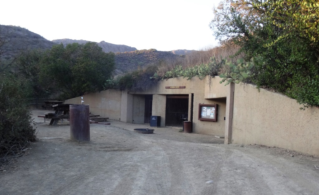
The Sycamore Canyon Nature Center is a small center located near the entrance to Sycamore Canyon Campground in Point Mugu State Park at 9000 Pacific Coast Highway. The center is open on Saturdays from noon to 3pm. Displays cover local wildlife, including specimens of a cougar, bobcat, birds of prey, and more. A volunteer is on hand to provide additional information.

El Encanto Trail in Dos Vientos Section of Newbury Park

ElEncanto_sign.JPG

If you're looking for quick access to gorgeous views in the Dos Vientos section of Newbury Park, from Thousand Oaks to Camarillo to the Santa Monica Mountains, stop by the roughly 1.2 mile El Encanto Trail. Access the trail either at the western endpoint of Kimber Drive, just past Greenway Avenue, or inside Dos Vientos at the eastern endpoint of Via Laguna, near the Calle Del Prado intersection.

After a fairly flat start off of Kimber, the trail gets a bit steep and narrow. My young kids were fine on it but it take a decent effort, with an elevation climb of about 300 feet.

And towards Thousand Oaks on the east

This little trail seems quite popular with mountain cyclists as well as hikers. Here's an inviting bench that awaits you near the top of the trail, about halfway between the Kimber and Via Laguna trailheads.

ElEncanto_Bench.JPG

The area was ravaged by the Springs Fire of 2013. The bench has an inscription dedicated to the efforts of the Ventura County Fire Department that did such a fantastic job protecting local neighborhoods.

ElEncanto_benchsign.JPG

If you start on the Kimber side all the way to the Via Laguna side, you can either retrace your steps back or take Calle Del Prado down to Via Rio, turning left (east) for a about a quarter mile walk back to the Kimber side.

For a detailed trail map of Dos Vientos area trails on the Conejo Open Space Foundation website, visit https://cosf.org/files/maps/dos_vientos_trail_map.pdf.

Upper Sycamore Canyon Trail in Point Mugu State Park

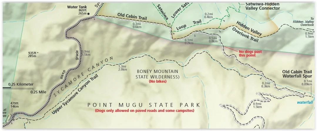
The Upper Sycamore Canyon Trail is a 1.3 mile trail connects to the bottom of steep Sycamore Canyon Fire Road on the west to the Danielson Road trail on the east.

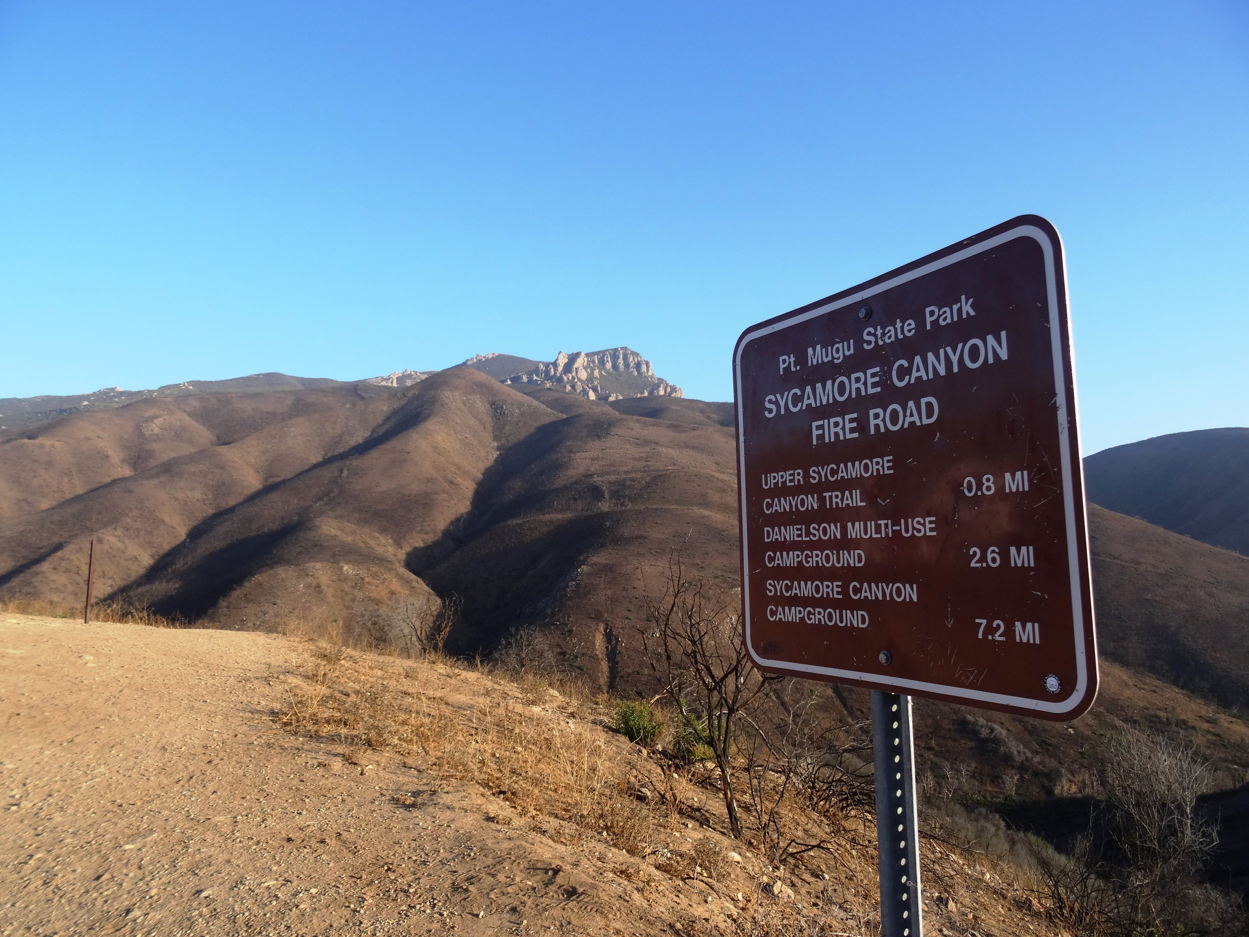
Sign at top of Sycamore Canyon Road before the descent into the canyon.

Sign at top of Sycamore Canyon Road before the descent into the canyon.

The trail goes deep into the canyon and can get quite overgrown, especially after solid winter rains. But it is an interesting hike and alternative to other trails that take you to "The Waterfall" in the Boney Mountain Wilderness. Bike and dogs are not allowed on these back country trails. Watch out of course for poison oak and snakes.

The "Narrow Bridge" sign marks the bottom of the steep initial grade down Sycamore Canyon Fire Road. You'll cross the bridge, then see the Upper Sycamore Canyon Trail entry to the left.

The "Narrow Bridge" sign marks the bottom of the steep initial grade down Sycamore Canyon Fire Road. You'll cross the bridge, then see the Upper Sycamore Canyon Trail entry to the left.

After you enter the west end of the Upper Sycamore Canyon Trail, within about a 1/10th of a mile is the entry point to the Fossil Trail, a very steep trail that leads up to the Old Boney Trail. 

Inside the canyon, looking west, towards the Sycamore Canyon Fire Road.

Inside the canyon, looking west, towards the Sycamore Canyon Fire Road.

After the substantial rains of Winter 2017, a creek has been flowing through this canyon and has caused some obstacles and overgrown sections of the trail. Do wear good hiking shoes.

Upper Sycamore Canyon Trail (Map excerpt courtesy of National Park Service)

Upper Sycamore Canyon Trail (Map excerpt courtesy of National Park Service)

Danielson Road sign you will see at the east end of Upper Sycamore Canyon Trail, Now you can head back up towards Rancho Sierra Vista/Satwiwa to the left or go the The Waterfall and/or Danielson Monument.

Danielson Road sign you will see at the east end of Upper Sycamore Canyon Trail, Now you can head back up towards Rancho Sierra Vista/Satwiwa to the left or go the The Waterfall and/or Danielson Monument.

Carbon Beach in Malibu

The Carbon Beach coastline as seen from the Malibu Pier.

The Carbon Beach coastline as seen from the Malibu Pier.

Carbon Beach is perhaps the most expensive 1 1/2 mile strip of beach in the world, located roughly between the Malibu Pier and just east of Carbon Canyon Road. 

The beach is wide, with lots of dry sand, making it particularly pristine and desirable, but public access is fairly limited, there are no public restrooms and dogs are not allowed.

According to the California Coastal Commission, in addition to "Public Access Easement" areas, "the public has the right to use all lands seaward of the ambulatory mean high tide line." Huh? This is no different than other beaches in California.

The access point on the west side of Carbon Beach is called the Zonker Harris* Access Way at 22670 Pacific Coast Highway, between Nobu Malibu (22706 PCH) and 22664 PCH (McDonald's is right across the street). 

* Opened in 1983 and named after the hippie Doonesbury character who worships the sun.

You can also park at the Malibu Pier and walk to Carbon Beach. It is about a half mile.

There is also public parking available on the upper floor of 22601 PCH on summer weekends and holidays.

The Carbon Beach West Public Accessway is at 22466 PCH. Funny, Google Maps actually refers to this as Billionaires Beach Public Access.

The Carbon Beach East Public Accessway is at 22126 PCH (in between 22140 PCH and the property at 22126 PCH - this is the property owned, or possibly now previously owned, by David Geffen).

And there you have it. For a pdf map from the California Coastal Commission showing public beach access at Carbon Canyon, click THIS LINK.

Thornhill Broome Campground in Point Mugu State Park

Thornhill Broome Family Campground is located at 9000 Pacific Coast Highway in Point Mugu State Park. The beachfront campground offers 68 tent/RV spaces. There are no hookups for RVs or flush toilets; just chemical toilets and cold outside showers. However, you are camping ON THE BEACH!

Thornhill camping.JPG

Sites have picnic tables and fire rings. Pets are allowed on leash in the campground. Reserve a spot at www.reservecalifornia.com (type in Point Mugu SP to find Thornhill Broome). Be aware that summer months in particular book up way in advance.

Keep in mind that there is no shade when you camp at the beach. So if you don't have an RV, be sure to bring a canopy and/or umbrella.

Thornhill Broome Beach is across from the gigantic sand dune that provides for a great workout and views. And due east is Sycamore Cove and Sycamore Canyon Campground (both also in Point Mugu State Park)...which of course is the most direct path...albeit by foot or bike...to Newbury Park and the Conejo Valley from the beach.

And of course the Sycamore Canyon Campground is across from Sycamore Cove, if you're looking for additional camping possibilities.

Traveling southeast on PCH from Oxnard/Camarillo; this sign tells you you're just about there.

Traveling southeast on PCH from Oxnard/Camarillo; this sign tells you you're just about there.

The cool, massive sand dune across from Thornhill Broome Beach (be careful crossing PCH!).

The cool, massive sand dune across from Thornhill Broome Beach (be careful crossing PCH!).

Conejo Ridge Open Space in Thousand Oaks

The Conejo Ridge Open Space is located in Thousand Oaks in a 406 acre area enclosed roughly as follows:

  • Rancho Road, Rimrock Road and the Los Padres Open Space on the west.

  • Los Robles Trail on the south.

  • The industrial park at 2400 Willow Lane (at Conejo Ridge Ave)

  • Highway 101 on the north.

While I have not completely explored this area, I do find it a great place for views of the Conejo Valley. One access point is at the west end of the parking lot at 2400 Willow Lane building that faces the 101. The trail briefly parallels the adjacent businesses in a southward direction, then veers west. It is a single track trail that is surprisingly well maintained.

At the top you’ll be treated to views towards the Conejo Grade on the west, Highway 23 and beyond on the north and Ladyface Mountain in Agoura Hills towards the east. You’ll also see what the traffic looks like on the 101 down below.

You can continue southwest bound to catch other trails and trailheads.

www.conejo-openspace.org/conejo-ridge.html

conejo ridge 2.jpg
conejo ridge 3.jpg

The Oaks Mall in Thousand Oaks

The Oaks in Thousand Oaks is located between the 101 Freeway and Lynn Road at 350 West Hillcrest Avenue, running east to Wilbur Road. Originally constructed in 1978, the 1.3 million square foot shopping mall was renovated in 1993 and again in 2008. In total, there are over 170 stores and services at The Oaks.

Well known brands at The Oaks include Nordstrom, Macy’s, JCPenney, The Apple Store, Anthropologie, Pottery Barn, Williams Sonoma and J.Crew.

Restaurants include The Cheesecake Factory, The Lazy Dog Café, Olive Garden, Urban Plates, Chipotle, Pedals & Pints Brewing Co., Bazille (inside Nordstroms), Wood Ranch BBQ, and coming soon, Plata Taqueria, as well as numerous options in the food court area.

The 2008 remodel brought a multi-level parking structure with over 1,300 parking spaces and digital signs that tell you how many spaces are available. There's a beautiful outdoor shops area on the east side of the mall that leads to AMC Thousand Oaks 14 and adjacent restaurants.

For more information, visit www.shoptheoaksmall.com or call 805.495.2032.

EV charging at The Oaks: Available on the south side behind AMC Theaters and the outdoor shops area from EVgo. Additional EV charging available free of charge on north side near Macy’s Men’s & Home Store and on the west side near Macy’s Women’s Store. There are Tesla Urban Superchargers on the south side of the parking structure.

Sycamore to the Sea Hike, Run or Bike From Newbury Park to Sycamore Cove

Did you know that you can walk, hike, run or bike from Newbury Park to the ocean over 8 1/4 miles pretty easily, without dealing with automobiles? Park your car at the Wendy and Potrero trailhead or at the Rancho Sierra Vista/Satwiwa parking lot in Newbury Park and experience it yourself.

The entry to the Rancho Sierra Vista/Satwiwa area.

The entry to the Rancho Sierra Vista/Satwiwa area.

The Satwiwa Native American Indian Culture Center is a short walk from the parking lot.

The Satwiwa Native American Indian Culture Center is a short walk from the parking lot.

From there, take the paved road, called the Sycamore Canyon Fire Road, towards the ocean.

From there, take the paved road, called the Sycamore Canyon Fire Road, towards the ocean.

PtMuguNewburyPark.JPG

This is a nice, wide paved road with trails along the side much of the way. Generally cool in the early morning year-round as you head towards the ocean, plenty of rest/pit stop areas on the way down and nice and peaceful and beautiful, full of canyons, trees and wildlife.

Sycamore Canyon Top.JPG

The steepest descent on this course is a roughly 800 foot drop over a 3/4 of a mile into the canyon on the paved road after you see this sign. Coming back up if you do the full round-trip circuit is a bit of a challenge.

SycamoreCanyonRoad.JPG

After you drop into the canyon, it is pretty much smooth sailing. The paved road stops right around the Danielson Multi-Use area (see image below for that juncture). After that, follow the wide, dirt fire road towards the beach.

Sycamore_RangerHouse.JPG

There are numerous water spigots on the side of the road going down, which comes in quite handy on warmer days. If you use them, just make sure to turn them off.

About 3/4ths of the way down to the beach, you'll pass one of the most picturesque locations for a porta-john that I've ever seen.

About 3/4ths of the way down to the beach, you'll pass one of the most picturesque locations for a porta-john that I've ever seen.

A few miles after passing the above porta-john, you'll reach the Sycamore Canyon Campground, which has 58 campsites and is across Pacific Coast Highway from the ocean. Cross over PCH (be careful!) or find the underpass that takes you under PCH to the Sycamore Cove Beach area, with picnic tables, bathrooms, etc., and enjoy your day!

Sycamore Cove Beach in Point Mugu

Sycamore Cove Beach in Point Mugu

From there, you either head back up or call your significant other to pick you up. Or perhaps plan it out in the morning to leave one car at the beach in either the Sycamore Canyon Campground or Sycamore Cove day lots (they open at 8am) for a fee, or park on PCH where there are spots near Thornhill Broome Beach and the giant sand dune, then drive another car back (obviously you can't do this alone), park the 2nd car at Rancho Sierra Vista/Satwiwa, hike/walk/bike down the canyon to retrieve car #1.

Or do what I did once, which was drive down to Sycamore Cove via Potrero Road/Las Posas/PCH, park the car, run (or perhaps ride) up to Newbury Park, then ride down with the kids and enjoy the beach. Fun! 

For a map of the Rancho Sierra Vista/Satwiwa area with a portion of the Big Sycamore Canyon Trail, visit www.nps.gov/samo/planyourvisit/upload/Rancho-Sierra-Vista_Satwiwa_2023.pdf (National Park Service pdf brochure).

Arroyo Simi Bike Path in Simi Valley

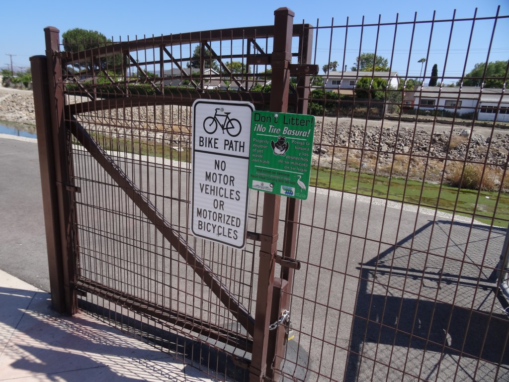
The Arroyo Simi Bike Path is a two lane bike path in Simi Valley that runs from Madera Road, just south of Easy Street on the west, ending at Cochran Avenue between Fig Street and Ralston Street on the east (more recently, the path has been extended east to Tapo Street).

Over seven miles in total. It is also referred to as the Arroyo Simi Greenway.

The Arroyo Simi is a waterway that begins at Corriganville Park in east Simi Valley and extends west all the way through Simi Valley until into merges into Arroyo Las Posas and Conejo Creek into Calleguas Creek. It is managed by the County of Ventura but the Rancho Simi Recreation and Park District has access to the pathway for recreational use.

While this path is nowhere near as visually appealing as bike paths along Ventura Beach and such, the Arroyo Simi Bike Path is almost entirely flat and allows passageway along much of Simi Valley from east to west. You can really do a lot of exploration from this artery. We like to park at the East Street entry point and bike to Rancho Simi Community Park (2.2 miles one way), Rancho Santa Susana Park (6 miles one way) and various other areas.

Because this path is so long and flat (and not crowded), it is a nice destination for learning to ride. However, do be aware that there are a number of street crossings where you are asked to walk your bike across. They are protected by lights and signs, however.

Arroyo Simi bike path entry point at Easy Street and Madera.

Arroyo Simi bike path entry point at Easy Street and Madera.

Arroyo Simi Bike path may not be the most picturesque path but is nicely flat and goes a long way!

Arroyo Simi Bike path may not be the most picturesque path but is nicely flat and goes a long way!

There are numerous entry points to the path, which largely parallels Los Angeles Avenue; this one is just east of Ralston off of Los Angeles Avenue.

There are numerous entry points to the path, which largely parallels Los Angeles Avenue; this one is just east of Ralston off of Los Angeles Avenue.

Hill Canyon, Hawk Canyon and Western Plateau Trails in Thousand Oaks

In 2012, the Conejo Canyons bridge was constructed in Thousand Oaks, opening up more trails to explore in the Western Plateau area of Thousand Oaks, which ties into Wildwood Park. Visit cosf.org/trails/conejo-canyons for trail maps.

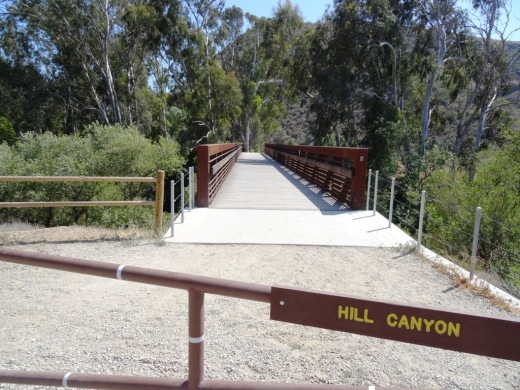
The Hill Canyon bridge that takes you to all the action!

The Hill Canyon bridge that takes you to all the action!

Access the Conejo Canyons bridge to get to the Hill Canyon Trail, a flat path that after a mile takes you to an intersection where you can go straight ahead to the Hawk Canyon Trail, take a right turn to the Western Plateau Trail or veer left to make your way to the Arroyo Conejo Trail that takes you about 2 1/2 miles to the Rancho Conejo Playfields in Newbury Park.

The Hill Canyon Trail is as flat as they come. I see bikers, hikers and runner back here.

The Hill Canyon Trail is as flat as they come. I see bikers, hikers and runner back here.

This creek parallels the Hill Canyon Trail

This creek parallels the Hill Canyon Trail

HillHawkJuncturesign.JPG

One path I enjoy is the Hill Canyon Trail to the Hawk Canyon Trail, which veers right towards the Western Plateau Trail, which loops back to Hill Canyon Trail.  Do look at a map first as signs are not always at trail junctures (the sign above is clearly an exception!). You can actually take the Hawk Canyon Trail as well as Western Plateau Trail to Newbury Park.

There’s also the Elliot Mountain Trail and Outlaw Loop Trail, accessible from the Western Plateau Trail.

Western Plateau Trail

Western Plateau Trail

When you reach the Western Plateau Trail, if you go just a bit further north/northeast, you'll be rewarded with great views down the Conejo Grade towards Camarillo and the Oxnard Plain.

Views from the Western Plateau Trail on a bit of an overcast June morning

Views from the Western Plateau Trail on a bit of an overcast June morning

Access the Conejo Canyons bridge via Santa Rosa Road. Coming from Thousand Oaks, take Moorpark Road north down the Norwegian Grade, where it intersects with Santa Rosa Road. Continue about 3.7 miles on Santa Rosa Road and make a left on Hill Canyon Road. Drive down Hill Canyon Road and you will see a large, flat dirt parking area on the right, adjacent to Santa Rosa Valley Regional Park.

Alaska Airlines Flight 261 Sundial Memorial at Hueneme Beach

The Alaska Airlines Flight 261 Sundial Memorial commemorates the 88 passengers and crew who lost their lives aboard Alaska Airlines Flight 261 near Anacapa Island on January 31, 2000. The flight was en route from Puerto Vallarta, Mexico to San Francisco and Seattle.

HuenemeSundial.JPG

The Memorial features a 36-foot diameter concrete plaza with a curving sand wall and seating area and a raised sundial in the center. The monument was designed by well known Santa Barbara sculptor James “Bud” Bottoms. The sundial’s bronze dolphins and triangular blade (gnomon) cast a shadow on the 20-foot diameter dial face oriented to Pacific Standard Time. Names of each of the victims are inscribed on individual bronze plates mounted on the perimeter of the dial.

AlaskaAirMemorialHueneme.jpg

The crash site is located between the mainland at Port Hueneme and Anacapa Island, one of the smallest islands in the Channel Islands chain, 14 miles offshore. Families of the lost passengers and crew dedicated the sundial as both a memorial to their loved ones and as a work of public art in gratitude to the residents of Port Hueneme for their compassion and tireless assistance in the recovery effort. This is a touching and lasting tribute to those who lost their lives on this flight.

Access the Sundial Memorial from Hueneme Beach parking lot B off Surfside Drive near the gazebo.

CLICK HERE FOR DETAILS ABOUT BEACHES SPANNING FROM CARPINTERIA TO MALIBU