Throwback Thursday - Grand Opening of Roy Rogers in Thousand Oaks in 1970

From the T.O. Library Conejo Through the Lens Collection is this photo at the grand opening of Roy Rogers Restaurant at 1140 Thousand Oaks Boulevard in 1970. This 1,950 sq ft structure was occupied by Roy Rogers until 1975, then it became Beef Corral, then, later that decade, Arby's. All three of these eateries specialized in roast beef sandwiches. Arby's closed its doors in May 2022 and as of August 2023 we are still awaiting an update on what the next occupant of that space will be.

Arby’s building still vacant as of mid-August 2023.

1983 Was the Last Year You Could Watch Drive-In Movies in the Conejo Valley

The Thousand Oaks Drive-In, located behind the current site of the Kohl's Department Store in Newbury Park at 1960 Newbury Road, was closed in 1983. This picture, courtesy of the Thousand Oaks Library Special Collections, was taken by local photographer Scott Harrison on October 11, 1983, shortly after the Drive-In was closed that year.

Thousand Oaks Library Special Collections, News Chronicle Collection. Photo by Scott Harrison.

Thousand Oaks Library Special Collections, News Chronicle Collection. Photo by Scott Harrison.

As you can tell from the sign in the picture, the last two films shown at the Drive-In were "Risky Business" and "Private School." The theater was torn down and eventually Kohl's opened in March 2004.

According to an August 4, 1997 Ventura County Star article, the Thousand Oaks Drive-In opened the first week of August 1967.  Seeing this picture certainly brings back childhood memories for me. There are over 150 other movie screens in the Conejo Valley and Ventura County today, but nothing compares to watching a movie while sitting in the comfort (arguably) of your own car!

Grand opening of the Thousand Oaks Drive-In Theatre in August 1967

Thousand Oaks Transit Provides Low Cost Transportation in the Conejo Valley

TOTransit_logo.png

Thousand Oaks Transit (TOT) offers five local bus routes serving the Conejo Valley. One way fares as of May 2023 are $2.00 per ride; 65+ seniors/disabled are $.50 and children 5 and under are free. Transfers from one bus to another are free and must be requested when you purchase your fare.

(NOTE: As of September 2022, all students in grades 1-12 as well as college students ride for free anywhere in Ventura County, with student ID.)

Buses are equipped with free Wi-Fi, security cameras and bike racks. Operating hours are Monday to Friday, 5 a.m. to 8 p.m. and Saturday 7 a.m. to 8 p.m.

TOT buses are equipped with destination signs on the front, side and rear of the bus. Here are the current bus routes:

  • Route 40 Newbury Park - Stops include Newbury Park High School, Borchard Park, Dos Vientos Community Center, The Oaks. 25 total stops.

  • Route 41 Midtown A - Stops include The Oaks, Los Robles Hospital, Cal Lutheran, Thousand Oaks High School, Teen and Senior Centers/T.O. Library, Transportation Center. 18 total stops.

  • Route 42 Midtown B - Stops include The Oaks, Conejo Valley High School, Thousand Oaks High School, Cal Lutheran, Los Robles Hospital, Conejo Valley Plaza, Janss Marketplace. 22 total stops.

  • Route 43 TOB Express - Stops include The Oaks, Transportation Center, City Hall, Westlake High School. 25 total stops.

  • Route 44 Crosstown - Stops include Westlake High School, The Oaks, Amgen. 35 total stops.

Exact fares are required on TOT buses in the form of cash, pass or transfer. Passes can be purchased on buses. Multi-day bus passes are available. Where's the bus? You can track them at www.nextbus.com.

Perhaps the most useful feature is the trip planner at www.toaks.org/departments/public-works/transit/plan-your-trip where you can type your location and destination and you’ll receive a step by step itinerary showing where to catch the bus and how long it takes to get to your destination.

TOTransit1.jpg

The Thousand Oaks Transportation Center located at 265 South Rancho Road (just south of the 101) is a transportation hub for eastern Ventura County.  The Center provides parking for transit users and rideshare participants and connects riders with the four routes described above as well as the following:

  • Several VCTC Intercity bus lines

  • Metro Line 161, which takes riders east with stops in Westlake Village, Agoura Hills, Calabasas, Woodland Hills and Warner Center.

  • LADOT Commuter Express 422 and 423 bus lines operating Monday to Friday as far as Downtown Los Angeles.

TOTransit2.JPG

To learn more, visit www.TOTransit.org or call 805.375.5473. There are bus schedules online, as well as at the Civic Arts Plaza (Public Works Counter on the 1st floor), Thousand Oaks/Newbury Park Libraries, Senior Center, Oaks Mall 2nd Floor Information Desk and at the Transportation Center.

The Giant Sand Dune on PCH Across From Thornhill Broome Beach in Point Mugu

One of the many unique things to see in Ventura County is the gigantic sand dune located on the east end of Thornhill Broome Beach in Point Mugu.

ThornhillSandDune.JPG

Driving north up PCH, you'll see the sand dune on the east side after passing by Sycamore Canyon/Sycamore Cove Beach and before reaching the entrance to the Thornhill Broome Campground. 

ThornhillBroomeDune1.JPG

Park on the shoulder off of PCH. There's plenty of room, though you may be partially parked in the sand. You can also park on the beach side of PCH but rather than taking your life in your hands jaywalking across PCH, you're better off parking on the mountain side of the highway.

The mysteriously large sand dune is the result of "Aeolian transport," or the wind's movement of particles, in this case, sand. Quite steep this hill is, but your effort will be rewarded with some beautiful views of the Pacific Ocean. Plus, you get a nice bird's eye view of Mugu Rock.

ThornhillBroomeDune3.JPG

We noticed that the southern-most portion of the sand dune seems to have more large rocks in the sand from erosion of the mountains above. The northern hill, at least the several times we've now been there since originally posting this, has somewhat less rocks, leaving the sand smoother and more comfortable to walk on.

Going down the hill is certainly a lot easier than coming up!

Elvis Presley "Wheels on My Heels" from "Roustabout" Filmed in Hidden Valley, Thousand Oaks, 1964

The 1964 musical film “Roustabout,” starring Elvis Presley, was filmed at Paramount Studios, with carnival scenes in Thousand Oaks. And there was this scene of Elvis on his Honda 305 Superhawk motorcycle in Hidden Valley, singing “Wheels on my Hills.”

It is remarkable how little has changed in Hidden Valley, 55 years after the Elvis film was shot.

Eateries That Opened in the First Half of 2023 and are Coming Soon to the Conejo Valley and Greater Ventura County

We’re mid-way through 2023 and have already seen several new dozen new eateries opening in the Conejo Valley and nearby areas, with another several dozen working to open in the coming months. See the list below.

New Eateries That Opened in the First Half of 2023

Powerline Trail to Edison Road to Conejo Mountain Peak in Newbury Park

View of Boney Mountain range from midway up the Powerline Trail in Newbury Park.

View of Boney Mountain range from midway up the Powerline Trail in Newbury Park.

While you're driving down the Conejo Grade from the Conejo Valley towards Camarillo, you may wonder what that mountain is south of the 101.  This would be the 1,814 foot tall Conejo Mountain.

So how do you get up there? 

There are no "official" marked trails to the peak of Conejo Mountain, but there are unofficial ways to get up there. One way that I'm aware of us via the Powerline Trail to Edison Road Trail in the Dos Vientos section of Newbury Park. 

Get to the Powerline Trail trailhead located on Via Ricardo, west of Via Pisa. Park on the street. Or for added trail mileage, park at Dos Vientos Community Park and take the short (1/2 mile) Park View Trail until it ends at Via Ricardo, where you'll see a crosswalk to the Powerline Trail on the other side.

Follow the Powerline Trail on a single to double tract trail until it reaches the much wider Edison Conejo Mountain Road, marked by sets of power line transmission towers.

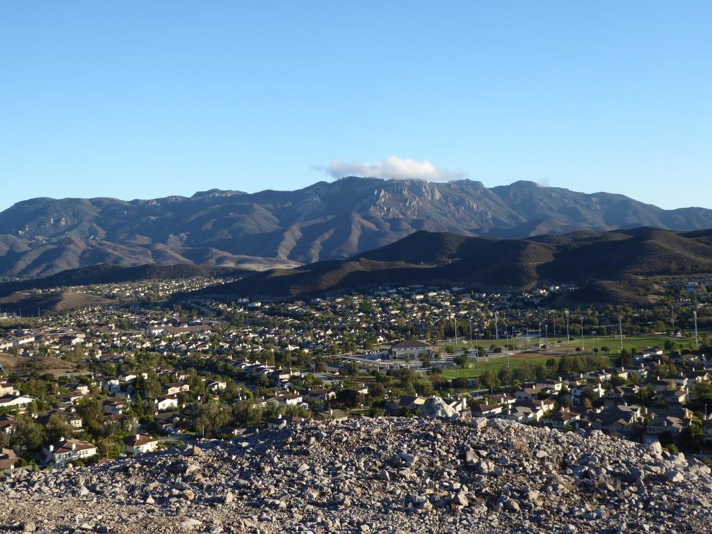
It is amazing how quiet it can get back here. This trail is a bit on the long, steep side and the mountain can get quite brown and barren. But the rock formations are pretty cool, and get more interesting the higher you climb. And the views are outstanding, from Boney Mountain to the south to the Channel Islands and Oxnard Plain to the west and Thousand Oaks to the east.

You will be passing by this anxiety-causing sign on the way up. Not to worry. Just a warning.

You will be passing by this anxiety-causing sign on the way up. Not to worry. Just a warning.

Now, pay attention, To find the path to the top of Conejo Mountain, count the pairs of transmission towers that you pass. The unmarked path is just above the 4th set of transmission towers, which is roughly two miles from the trailhead.

When I went, there was fairly large arrow formed with rocks that pointed in the direction of the path. Although it is not an official trail, you can kind of make out the path that has been cleared by hikers over the years. And there are some sections where it appears the path has been aligned by rocks.

In any case, although it looks difficult, it actually isn't that bad, as long as you take your time and watch your step. When you reach the top, you will have a clear birds eye view of the 101 on the other side.of the mountain.

When it greens up after the winter storms, it sure looks a lot prettier up here.

When it greens up after the winter storms, it sure looks a lot prettier up here.

A clear view of Highway 101 from the peak of Conejo Mountain.

A clear view of Highway 101 from the peak of Conejo Mountain.

Clear, unimpeded views of Anacapa and Santa Cruz Islands from up here.

Clear, unimpeded views of Anacapa and Santa Cruz Islands from up here.