CDC Reports Over 200,000 Preventable Heart Disease and Stroke Deaths Annually


More than 200,000 preventable deaths from heart disease and stroke occurred in the United States in 2010, according to the Centers for Disease Control and Prevention.  More than half of these deaths happened to people younger than 65 years of age, and the overall rate of preventable deaths from heart disease and stroke dropped nearly 30 percent between 2001 and 2010, with the declines varying by age.  Lack of access to preventive screenings and early treatment for high blood pressure and high cholesterol could explain the differences among age groups.

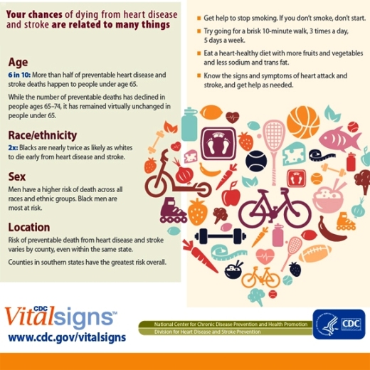
  • Age: Death rates in 2010 were highest among adults aged 65-74 years (401.5 per 100,000 population).  But preventable deaths have declined faster in those aged 65–74 years compared to those under age 65.
  • Race/ethnicity: Blacks are twice as likely—and Hispanics are slightly less likely—as whites to die from preventable heart disease and stroke.
  • Sex: Avoidable deaths from heart disease, stroke and high blood pressure were higher among males (83.7 per 100,000) than females (39.6 per 100,000). Black men have the highest risk. Hispanic men are twice as likely as Hispanic women to die from preventable heart disease and stroke.
  • Location: By state, avoidable deaths from cardiovascular disease ranged from a rate of 36.3 deaths per 100,000 population in Minnesota to 99.6 deaths per 100,000 in the District of Columbia. By county, the highest avoidable death rates in 2010 were concentrated primarily in the southern Appalachian region and much of Tennessee, Arkansas, Mississippi, Louisiana, and Oklahoma.  The lowest rates were in the West, Midwest, and Northeast regions.

To save more lives from these preventable deaths, doctors, nurses, and other health care providers can encourage healthy habits at every patient visit, including not smoking, increasing physical activity, eating a healthy diet, maintaining a healthy weight, and taking medicines as directed.

Learn more about CDC’s heart disease, stroke, and high blood pressure initiatives, and the national Million Hearts initiative.

Ventura County Recognizes September as National Preparedness Month

September is National Preparedness Month and the County of Ventura is joining the nationwide effort to encourage individuals, families, businesses and organizations to prepare for emergencies by getting a kit, making a plan, staying informed and getting involved in their local community.

At 10:00 a.m. on September 10, 2013, the Ventura County Board of Supervisors will proclaim September as National Preparedness Month in Ventura County.

Preparedness is important because in the event of a local emergency, Ventura County residents may need to be self-reliant for at least three days without access to electricity, water service, or food. “Being prepared is a shared responsibility and everyone should do their part,” said Kevin McGowan, Assistant Director of the Ventura County Sheriff’s Office of Emergency Services. “Emergencies will happen, so I urge residents to be proactive and get prepared before disasters strike”.

Ventura County residents can take simple steps to be better prepared for disasters by making an emergency supply kit, developing a family communications plan, staying informed of the local hazards and getting involved in our community.

CLICK HERE for an Emergency Supply List.

For more information on how to be better prepared, visit the Ready Ventura County website at www.readyventuracounty.org as well as on Facebook (www.facebook.com/ReadyVC) and Twitter (www.twitter.com/ReadyVC) for weekly preparedness tips, news and events.

Touching Story of 96 Year Old Fred Stobaugh and the Song He Wrote For Wife Lorraine

Grab the tissues. Here's a touching story of a man named Fred, 96 years old, who responded to a singer/songwriter contest with lyrics to a song to his wife, Lorraine. Although his entry was not accepted because his lyrics were not sung by him, his lyrics are brought to life. Watch the video to see what happens, and his reaction.

Thousand Oaks Police Department Reminds Drivers to Slow Down

According to the Thousand Oaks Police Department, in the past 12 months there have been seven fatal traffic collisions in the City of Thousand Oaks. Four of these fatalities have occurred on Westlake Boulevard. Three of the fatalities were motorcycle riders and the one this week was a solo vehicle into a power pole. Speeding was a factor in all of the accidents. The victims were boys 21 years of age and younger.

As a result of the latest traffic collision, a 17-year-old passenger is still in critical, but stable condition. Both boys in the last accident were scheduled to start their senior year at Thousand Oaks High School this week.

The Thousand Oaks Traffic Division would like to put an end to these tragedies. Therefore, the traffic division will be increasing enforcement in this area and other areas prone to speeding in an effort to make the roadway safer.

Please take the time drive safely. Most importantly, reduce your speed and obey all traffic laws.

Source: Thousand Oaks Police Department

Speaking of speeding teens, less than two weeks ago my wife and kids were driving on Lynn Road near the 101 in the late afternoon when another local teen managed to lose control of the car he was driving and barrel across the median into oncoming traffic, totaling both cars. SLOW DOWN indeed and don't even think about texting while driving!

Experiencing the Mishe Mokwa Trail to Sandstone Peak Hike with My Kids

Sandstone1.jpg

On the President's Day holiday I took my boys to the Sandstone Peak trailhead in the Santa Monica Mountains in Malibu for the six mile Mishe Mokwa Trail to Sandstone Peak.

I've discovered that many, perhaps even most, local residents have never heard of Sandstone Peak. They know about the prominent Boney Mountain overlooking the Conejo Valley, but the highest peak in the Santa Monica Mountain range at 3,111 feet is something new!

Well Sandstone Peak is something that you must explore at some point. Not exactly for the faint of heart, this peak provides panoramic, 360 degree views stretching from the Channel Islands, Conejo Valley, San Fernando Valley and beyond.

Perhaps the biggest challenge is getting to the trailhead. While only 12 miles from the Westlake Boulevard/101 freeway juncture, it take close to 30 minutes to get there via the winding, Decker Canyon, Mulholland Road and Yerba Buena Road. The main dirt parking lot has room for perhaps 25 cars, while there are several smaller dirt lots and some street parking available.

MisheMokwaTrailhead.JPG

Once we parked, I made sure we had water and snacks packed. We started our trek around 2pm on a cool afternoon, so I also made sure to pack a second layer for us. The first section of the hike from the parking lot to the Mishe Mokwa trailhead is probably the steepest stretch of the entire hike. So of course about 27 steps into the hike my youngest (age 7) wants to stop and take a break. Uggh. But after finding some distractions on the trail, we made it to the Mishe Mokwa trailhead sign. Yippee!

View of Balanced Rock from the south.

View of Balanced Rock from the south.

The first half of the hike is mainly north/northeast facing and was almost entirely shaded. The trail is fairly moderate all the way to Split Rock, though there are a couple slightly "dicey" sections where the kids made my blood pressure go up a bit.

Within a few miles, you'll see the famous Balanced Rock (pictured above), a display that has you staring in amazement. How the heck that large rock balances on the smaller one is beyond me. And the photo (as well as this closer view from the north on Pinterest) does not do it justice.

Navigating one of the more narrow sections of the trail overlooking Balanced Rock

Navigating one of the more narrow sections of the trail overlooking Balanced Rock

Just west of Balanced Rock is a small stream and Split Rock, a large boulder with a crack in it large enough to walk through. There's also a picnic bench here, where you can relax and replenish. In the canyons between Balanced Rock and Split Rock are the Echo Cliffs...aptly named as the echo effect in that area is quite fun to explore. Many folks hike to Split Rock, enjoy a picnic, then head back. Or you can continue onward for the full 6 mile or so loop to Sandstone Peak and back.

Split Rock, about 2 miles into the hike

Split Rock, about 2 miles into the hike

MosheMikwaRockFace.JPG

The section of the Mishe Mokwa Trail between Split Rock and the Backbone Trail intersection is about 1 1/2 miles or so.

The sign telling us we are (finally) almost at the Backbone Trail, which will take us to Sandstone Peak and back to our car on Yerba Buena Road

The sign telling us we are (finally) almost at the Backbone Trail, which will take us to Sandstone Peak and back to our car on Yerba Buena Road

Views from Sandstone Peak looking north towards the Conejo Valley/Ventura County

Views from Sandstone Peak looking north towards the Conejo Valley/Ventura County

We had been heading north/northwest on the Mishe Mokwa trail and now we were heading east on the Backbone Trail. A couple times I was slightly confused by offshoot trails, but we found the way by staying on the main trails.

It's a bit of a challenge and rock climb to get to the actual top of Sandstone Peak once you reach its base (CLICK HERE for more details). And once you reach the top, looking down at the canyons below, with the kids running around, can be quite unnerving. (In fact, if your kids are really "active" you may not want to bring them to the top...kind of scary...and dangerous.) But we made it up there and survived!

Views from Sandstone Peak looking towards the Pacific Ocean

Views from Sandstone Peak looking towards the Pacific Ocean

Find out more about this and other hikes on the National Park Service Circle X Ranch website at www.nps.gov/samo/planyourvisit/circlexranch.htm, where you will find a detailed pdf map of the various hikes in that area.

SandstoneMap.jpg

Circle X area map excerpt courtesy of National Park Service. Full map with detailed information at www.nps.gov/samo/planyourvisit/circlexranch.htm.

Thousand Oaks Police Department Message Regarding AMBER Alert System Importance

Like many of you, I was sitting at my desk on Monday night when I was startled by the high pitched AMBER alert that appeared on my smartphone. Following is a messge from the Thousand Oaks Police Department today regarding the importance of the AMBER Alert System.

In the last week there has been a lot of curiosity regarding the AMBER Alert System. You may have received a text message on your cell phone or may have seen the numerous traffic signs indicating an AMBER Alert was issued. The AMBER Alert system most recently proved to be successful with locating the abducted teen from San Diego. This system has shown its continued value to the public and law enforcement officers since its inception.

The history of the AMBER Alert System began in Texas in 1996, when broadcasters teamed with local police to develop an early warning system to help find abducted children.

AMBER stands for America's Missing: Broadcast Emergency Response and was created as a legacy to 9-year-old Amber Hagerman, who was kidnapped while riding her bicycle in Arlington, Texas, and then brutally murdered. Other states and communities soon set up their own AMBER plans as the idea was adopted across the nation.

How does it work?

Once law enforcement determines that a child has been abducted and the abduction meets AMBER Alert criteria, law enforcement issues an AMBER Alert and notifies broadcasters and state transportation officials. AMBER Alerts interrupt regular programming and are broadcast on radio and television and on highway signs. AMBER Alerts can also be issued on lottery tickets, wireless devices such as mobile phones, and over the Internet.

Are AMBER Alerts issued for all missing children?

AMBER Alerts are issued for abducted children when the situation meets the AMBER Alert criteria. When a child is missing, law enforcement can act swiftly to help recover the child, by developing search and rescue teams or by bringing dogs to the scene to track the scent. AMBER Alert

Read More