Lewis Road Pedestrian Overcrossing in Agoura Hills

This is the Lewis Road Pedestrian Overcrossing, Caltrans Bridge #53-998, in Agoura Hills. It connects Roadside Drive at Lewis Road on the south to Canwood Street at Lewis Road on the north side of the 101. It was built in 1963 and expanded in 1973.

This is the only pedestrian bridge going over a freeway in the Conejo Valley. There is another pedestrian bridge in Thousand Oaks - the Luedtke Bridge over Olsen Road that connects the CLU main campus to the northern campus.

Building Pacific Coast Highway Around Point Mugu in 1923-1924

Point Mugu before and after creation of a narrow road around it in 1924.

Point Mugu before and after creation of a narrow road around it in 1924.

According to the California Highway Commission in the October 1924 issue of “California Highways,” perhaps the most dangerous and difficult piece of construction work on the California state highway system at that time was the 3800 feet of grading AROUND Point Mugu.

For those driving Pacific Coast Highway in Ventura County past Mugu Rock, there are clear signs of this old route that took automobiles on a precarious route around Point Mugu.

Peaking through the fence towards the old road around Mugu Rock.

Peaking through the fence towards the old road around Mugu Rock.

The new and still existing route was created by blasting a massive hole through Point Mugu to create Mugu Rock in 1937 to 1940.

The work to complete this section of the Oxnard to San Juan Capistrano PCH route was authorized by a bond issue in 1919.

The project averaged 60 workers who moved 108,000 cubic yards or rock at a total cost of $108,500 (heck, that would be the cost of a pool addition and new kitchen remodel today). The cut around Point Mugu ranged from 40 feet on the ocean side to 115 feet on the high side in creating the narrow, short-lived roadway.

The California Highway Commission ended its article by stating “…along this piece of rugged coast line the Old Pacific is recognized as an arch enemy to whom we must trust as little as possible of our costly highway.”

Bank of America "Museums on Us" Program Offers Free Admission to Over 225 Museums Nationwide

MuseumsOnUs.jpg

If you are a Bank of America or Merrill Lynch customer, your bank credit or debit card and photo ID will gain you one free admission to over 225 cultural institutions across the country on the first full weekend of each month. Visit the "Museums on Us" program website at museums.bankofamerica.com for details.

And while there are no Ventura County museums on the list, there are a number of other choices within driving range:

  • Autry National Center of the American West

  • Los Angeles County Museum of Art

  • Skirball Cultural Center

  • Museum of Latin American Art in Long Beach (Saturdays only)

  • Discovery Science Center, DiscoveryCube Orange County (Sundays only)

  • Santa Barbara Museum of Art

  • MOXI, The Wolf Museum of Exploration + Innovation in Santa Barbara

Free admission is limited to individual cardholder at participating institutions.

Mugu Rock Then and Now

Mugu Rock is a large rock formation formed when a 200 foot deep cut was made into the rocky ridge from October 1937 to February 1940. Prior to the modern day PCH at Mugu Rock (at the time called U.S. 101 Alternate (State Route 60), drivers went around a 275 foot radius curve that is now fenced off.

The photos in the video above from the October 1940 edition of California Highways and Public Works show what it looked like before, during and after the cut was made, compared to what it looks like today.

What's the Deal With All of Those Signs Posted at the Swimming Pool

My kids get a laugh from time to time when they notice the sign at the public swimming pool that states, "Persons having currently active diarrhea or who have had active diarrhea within the previous 14 days shall not be allowed to enter the pool water." 

The thought comes to mind, should one have had this issue, how many people would actually remember if it was within the last 14 days. Heck, I can't even remember what I ate for breakfast yesterday and what I watched on TV last Sunday.

But the sign is well intended as waterborne disease is no laughing matter. Waterborne disease outbreaks in pools have often been caused by individuals with recent diarrhea; chlorine doesn't always take care of removing the viruses or parasites that can come from those with recent symptoms.

The requirement for this and other community pool signs comes from California Building Code Chapter 31B "Public Pools," Section 3120B "Required Signs."

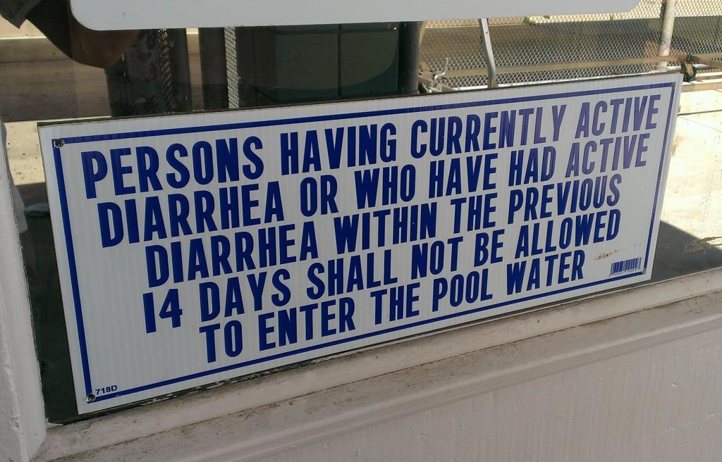
Section 3120B.11 "Diarrhea" indicates the sign must have letters at least 1 inch high, clearly states what is noted above, and is posted at the entrance area of a public pool. Public pools include municipal/park district pools, hotel pools, water parks, swim schools, homeowner shared pools, apartment pools, campground pools, etc. One is thus not required to post this sign at your home pool (unless you really want to).

CDC ADVICE TO PREVENT INFECTIONS FROM PUBLIC SWIMMING POOLS

According to this source, the diarrhea sign and a variety of other pool signs were put into law in late 2012. Some examples of other public pool sign requirements include:

  • "No Diving" sign for pools with maximum depth of 6 feet or less

  • "No Lifeguard" sign when applicable

  • Emergency sign with 911 and nearest emergency services

  • "No use after dark" sign for pools without lighting

  • Artificial respiration and CPR sign

  • Pool user capacity sign (1 person per 10 sq ft in spa; 1 person per 20 sq ft in pool)

So you've learned something new. If you'd like to read the entire 28 pages of Chapter 31B of the California Building Code, or any of the Code for that matter, visit www.bsc.ca.gov/Codes.aspx.

DOZENS OF VENTURA COUNTY AREAS SWIMMING POOLS AND WATER PLAY PLACES

The Ventura County Portion of State Highway Route 1 is Named "Ventura County Vietnam Veterans Memorial Highway"

California State Route 1 runs along most of the coastline of California and at 656 miles is the longest state route in California. The section of SR 1 between I-5 in Dana Point and the US 101 near Oxnard is designated Pacific Coast Highway.

Sign at the indicating the north end of southbound PCH, where it connects to Las Posas Road.

Sign at the indicating the north end of southbound PCH, where it connects to Las Posas Road.

In 2002, the state assembly voted to designate the section of State Highway Route 1 in Ventura County as the “Ventura County Vietnam Veterans Memorial Highway” in gratitude and appreciation for the sacrifices California Vietnam veterans.

VC Vietnam Veterans Highway1.JPG

That same bill also designated the portion of State Highway Route 126 between the City of Santa Paula and State Highway Route 101 as the Korean War Veterans Memorial Highway.

How Do I Find the Nearest Mailbox to Me?

mailbox.jpg

My wife asked me if there is a way of finding the nearest local mailbox.  Sure, we know of a couple mailboxes within a mile of our home in the Conejo Valley but it's nice to be able to find other mailboxes when you're out and about.

She used to put letters and bills and such in the mailbox for our mail carrier to pick up, but with the rash of folks swiping things out of home mailboxes, she would prefer to drop letters off into a more secure "blue" mailbox.

The US Post Office has a "Find Locations" section on its website to find a variety of locations, including post offices, approved postal providers, self-service kiosks and collection boxes (aka mailboxes). Find your local mailbox at tools.usps.com/find-location.htm. This tool on the USPS site works great and provides additional information, including daily pickup times.

And of course since there's data out there on where the mailboxes are, there are websites that take that this data and create their own mailbox map. Mailboxmap.com does just this. Simply type in your location and the map will clearly lay out mailbox, post offices and UPS stores for your mailing needs.