The Historic Elizabeth Bard Memorial Building in Downtown Ventura

Elizabeth Bard Memorial Building in Downtown Ventura is on the National Register of Historic Places.

Elizabeth Bard Memorial Building in Downtown Ventura is on the National Register of Historic Places.

The Elizabeth Bard Memorial Building is located at Fir and Poli Streets in Ventura. Built in 1901, it operated as the Elizabeth Bard Memorial Hospital for 30 years. This building, listed as a Ventura Historic Landmark and added to the coveted National Register of Historic Places in 1977, is a Mission Revival structure featuring covered terraces and a covered porch with a three-story bell tower at the southeast corner.

In 1932 the building was sold to the County of Ventura and was used as county offices and as a detention facility. Eventually it fell into disrepair and was sold to private investors in 1982, after which it was extensively renovated...but the external facades were preserved.

Now it is home to a variety of businesses. Yours truly worked in this building for about a year many years ago. Great location! Close to the Ventura Botantical Gardens Trail, which is making a comeback from the Thomas Fire of 2017.

While the building is not open to the general public (unless you are visiting one of the businesses located in it), it is worth admiring this beautiful and historic part of Ventura County.

Elizabeth Bard Memorial Hospital in 1910.

Elizabeth Bard Memorial Hospital in 1910.

Point Mugu Missile Park in Port Hueneme

Naval Base Ventura County hosts "Missile Park" at the juncture of Wood Road and Naval Air Road in Port Hueneme. It is roughly 20 miles from central Thousand Oaks. Take the 101 west to Lewis Road south, then left on Wood Road until it ends at Missile Park. You can't miss it!

While it is called a park, Missile Park is primarily an interesting display of various aircraft and missiles that have been tested at the Naval Base since World War II.

Aircraft on display include an F-14 Tomcat and an F-4 Phantom II. The Phantom II was a two seat, tandem, twin-engine, all weather, long range supersonic jet interceptor fighter that was in service from 1960 to 1996. The Tomcat is a supersonic, two seat, twin-engine fighter craft. The F-14A on display was the 24th F-14 Tomcat manufactured by Grumman Aerospace Corporation and was last flown in January 1993. It belongs to the National Museum of Naval Aviation and is on permanent display at Missile Park.

There is quite a wide array missiles on display at the park, including an AMRAAM missile, Regulus submarine-launched missile, Sidewinder missile, the Loon missile (an American copy of the German V-1), the BQM-34S "Firebee" Aerial Target, the Polaris ballistic missile, Petrel torpedo, Harpoon missile, Phoenix air-to-air missile, Bullpup air-to-surface missile and others.

There is a small parking area at Missile Park, a picnic bench, trash receptacles, but nothing else, other than the displays. No restrooms. Open daily from sunrise to sunset. 

Ventura and Oxnard Historical Pictures, Courtesy of the U.C. Cooperative Extension

The University of California Cooperative Extension brings research-based information to Californians.  It is an educational outreach program, that, with the help of thousands of volunteers, assists with nutrition and 4-H youth development programs, agriculture, horticulture, natural resources, gardening and other areas.  For more information, visit http://ceventura.ucdavis.edu.

Through the UCCE website I came across this really neat slideshow with historical pictures of Ventura and Oxnard from mid to late 1800s to the early 1900s.  The slideshow was originally created in 1963.  There are interesting and informative descriptions with each photo.  Many thanks to Steve Griffin of the U.C. Cooperative Extension in Ventura who patched the original pictures and descriptions together to make this available to the public.

La Conchita Bike Path Between Mobil Pier Road in Ventura to Rincon Point

My choice for most awesome Class I Bike Path in Ventura County is the La Conchita Bike Path that runs from Mobil Pier Road in Ventura (southwest of Mussel Shoals) to Rincon Point. The path is directly adjacent to the southbound Highway 101.

Entry point to La Conchita Bike Path at Rincon Point Rd/Bates Rd (directly adjacent to the 101 onramp).

Entry point to La Conchita Bike Path at Rincon Point Rd/Bates Rd (directly adjacent to the 101 onramp).

This distinct path premiered in September 2014 and provides for roughly 4 miles of unimpeded views of the Pacific Ocean on the west and is directly adjacent to the hustle and bustle of Highway 101 on the other side.

Do views from a bike path ever get any better than this!!??

Do views from a bike path ever get any better than this!!??

Class I bike paths are great to bring the entire family on as they are completely separate from street traffic. My kids love this path because it is flat, in great condition and is just so beautiful that its hard not to ride this path without a smile.

This separates the path from southbound 101 traffic. Pretty amazing riding carefree adjacent to the 101.

This separates the path from southbound 101 traffic. Pretty amazing riding carefree adjacent to the 101.

We brought the bikes to Rincon Beach Park to start our journey on the north end of the path. (Alternatively, park at Rincon Point or on Rincon Pt Road.) You first get to see surfers at the world famous Rincon Point, then on to the La Conchita Beach area.

One of several beach access points to the La Conchita Beach area.

One of several beach access points to the La Conchita Beach area.

There are several beach access points along the path.  As part of this project, Caltrans built an undercrossing to enable folks to walk to the beach from La Conchita

After La Conchita you reach a stopping point at the small community of Mussel Shoals, where you can stop at the Cliff House Inn for a drink and check out the man-made Rincon Island.

A quick stop to view the man-made an inaccessible Rincon Island

A quick stop to view the man-made an inaccessible Rincon Island

Walk your bikes across the offramp to the next bike path entry point, on to the next section of path that half circles southeast to its endpoint at Mobil Pier Road.

You cross here (signs indicate you must walk bikes across) to the next access point.

You cross here (signs indicate you must walk bikes across) to the next access point.

You will see beach area here referred to as Oil Piers Beach. There used to be piers here but they were taken down in 1998.  There is parking on Mobil Pier Road for beach/bike path access; you can park here and ride the path the opposite direction.

The beauty continues (except for the graffiti) as you ride towards Mobil Pier Road.

The beauty continues (except for the graffiti) as you ride towards Mobil Pier Road.

Mobil Pier Road is the endpoint of this Class I path, but, you can continue south if you'd like by taking the Mobil Pier Road underpass below the 101 to Pacific Coast Highway going south, past Hobson Beach Park, Rincon Parkway, Faria Beach Park and so on. This section is not Class I path but I've taken my kids here and we enjoy it.

Great stuff! A Ventura County "Bucket List" item that all of you have to try!

Conejo Creek Park North in Thousand Oaks is a Perennial Family Favorite

Conejo Creek Park North is one of the nicest, widest appealing parks throughout Ventura County. You get almost everything at this park. This 44 acre park has two ponds with a stream connecting them, two separate play areas, beach-style volleyball courts, a NEOS game, multiple large, shaded picnic areas. a fitness trail about 2/3rds of a mile that circles the park, plenty of shade trees and multiple large, grassy areas. Something for everyone.

Topping it off is the fact that the park is adjacent to the beautiful Grant R. Brimhall Library, Goebel Senior Center and Thousand Oaks Teen Center. We often park at the library, check out some books, then walk, scooter or ride across a bridge to the park. It is a great way to spend the day.

Conejo Creek Park North is extremely popular for larger events on the upper grass area adjacent to the largest picnic structure. There is plenty of parking available. And in the middle of the park is a jungle-like trail area that I enjoy exploring with the kids. We also see birthday party celebrations all the time.

To learn more about Conejo Creek Park North, visit the Conejo Recreation and Park District website at www.crpd.org. To learn about other parks we enjoy in and around Ventura County, click THIS LINK.

Father Junipero Serra Statue in Downtown Ventura

NOTE: On June 18, 2020, the City of Ventura issued a press release stating that it plans to work with members of the community in moving the statue of Father Junipero Serra to a new, non-public location.


Father Junipero Serra (1713-1784) was a Roman Catholic Spanish Franciscan friar who founded nine Spanish Missions in California stretching from San Diego to Carmel. 

The last of these nine missions, founded on March 31, 1782, was Mission San Buenaventura, which today is an active parish of 3,000 members located at 211 East Main Street in Ventura.

Serra was beatified by Pope John Paul II on September 25, 1988, and canonized by Pope Francis on September 23, 2015, at the Basilica of the National Shrine of the Immaculate Conception in Washington, D.C. - the first canonization ceremony to be held in the country.

Located on a pedestrian island in front of Ventura City Hall at the intersection of N. California Street and Poli Street is a bronze statue of Father Junipero Serra.

JuniperoSerraSign.jpg

In 1936, the Federal Art Project (part of the New Deal) funded this heroic sculpture. Finnish sculptor John Palo-Kangas originally cast it in cement, which decayed over the years.

The present statue, an exact replica of the original statue, was cast in bronze and dedicated on October 20, 1989. A wooden duplicate used in the making of the bronze statue can be seen in the City Hall Atrium.

According to the Mission San Buenaventura website, Serra stood just 5 feet, 2 inches in height. This statue is over 9 feet tall. Go check it out!

Rattlesnake Do's and Don'ts in the Trails of the Conejo Valley and Neighboring Areas

I've seen more snakes in the trails of the Conejo Valley in recent years than I can ever recall, some, but not all of which are rattlesnakes.

According to the California Department of Fish and Wildlife, rattlesnakes are generally not aggressive but can strike when they feel threatened or provoked. If you come across one on the trail, just back off and give them room to retreat. They don't want to mess with you!

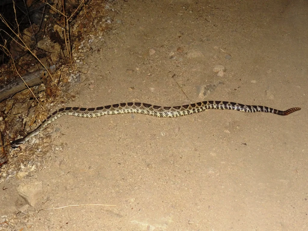
Rattler crossing the Rosewood Trail on a sunset hike.

Rattler crossing the Rosewood Trail on a sunset hike.

It is rare that rattlesnakes cause serious injury to humans. According to the California Poison Control Center, rattlesnakes account for 800 bites each year, with only one or two deaths. Most bites occur during the months of April through October, when both humans and snakes are active outdoors. About 25% of bites are dry (i.e. no venom), but still require medical treatment.

Do's and Don'ts

  • Wear shoes when out hiking in the trails.

  • Stay ON the trails...don't venture out into the underbrush, where snakes may be hiding.

  • Watch what you touch with your hands too...especially if it's dark and hard to see.

  • Leave them alone. They are fun to watch, but do so from a distance. Don't try to pick them up.

Is it a Rattler or a Gopher Snake?

On the trails of the Conejo Valley I've come across rattlesnakes, gopher snakes, king snakes, garter snakes and perhaps a few others I wasn't able to identify. The rattlesnakes are the ones to be particularly wary of because of their venom, so be aware of the following distinctions:

Rattlesnakes are wider/heavier than most of the other local snakes and have a triangular-shaped head, broader at the back than at the front, with a distinct "neck." They have openings between the nostrils and the eyes. There are a series of dark and light bands near the tail which look different from the markings on the rest of the body.  DO NOTE that rattles may not always be present as they may have fallen off are are not always developed on a young rattler.

For some great information on identifying California snakes, visit www.californiaherps.com/identification/snakesid/common.html.

Notice the stocky size of this rattlesnake, the clear rattle, and the different series of dark and lights bands leading down towards the rattle.

Notice the stocky size of this rattlesnake, the clear rattle, and the different series of dark and lights bands leading down towards the rattle.

Beautiful King Snake (known for lunching on rattlesnakes).

Beautiful King Snake (known for lunching on rattlesnakes).

Gopher snake crossing the trail in Rancho Sierra Vista/Satwiwa.

Gopher snake crossing the trail in Rancho Sierra Vista/Satwiwa.

Gopher snake on the Vista Del Mar Trail in Newbury Park.

Gopher snake on the Vista Del Mar Trail in Newbury Park.