The Adamson House in Malibu is Listed on the National Register of Historic Places

AdamsonHouse_front.JPG

The Adamson House at 23200 Pacific Coast Highway in Malibu is a National Historic Site and a registered California landmark. The house and grounds share one of the most beautiful beach locations in Southern California, with a view of the Malibu Lagoon, Malibu Beach and the Malibu Pier. In addition to its world-famous Malibu Tile, the house contains hand-carved teak wood doors, hand-painted murals, molded ceilings, hand-wrought ironwork and lead-framed bottle glass windows.

AdamsonHouse_sign.JPG

The house was built in 1930 for Rhoda Rindge Adamson and Merritt Huntley Adamson, originally as a summer cottage and in 1936 as the family's primary residence. It is located on the 13,315 acre Malibu Rancho that was purchased by Rhoda's parents, Frederick and May K. Rindge, in 1892.  Mr. Rindge passed away in 1905 and left the ranch to his wife, who later gave the parcel to the Adamsons.

USC graduate Merritt Adamson met Rhoda Rindge while he was employed as foreman of the Rindge Ranch. The couple married in 1915 and in 1916 Merritt founded Adohr Farms in the San Fernando Valley, named after his wife's first name spelled backwards.

AdamsonHouse_historic.jpg

Rhoda inherited the property after Merritt's death in 1949 and she lived there until her passing in 1962. The land was later purchased by the State of California under eminent domain laws to create beach parking, but local groups and preservationists fought to preserve the property and succeeded. The house was restored and the garage was converted into the Malibu Lagoon Museum and they opened to the public in 1983.

Flooring in the backside of the house

Flooring in the backside of the house

The Adamson House Tour is a guided tour through the house which contains its original furnishings and is decorated with the renowned Malibu Potteries tile. Trained volunteer docents relate the history of the house, details of its architecture and furnishings, and the history of the family that lived in and created this distinctive home. Admission (as of November 2025) is $7 for ages 17 and up, $2 ages 6 to 16 and free for under 6. Cash only. Open for guided tours 11am to 2pm Wed to Sat. More information at www.adamsonhouse.org or call 310.456.8432.

Former Olympia Farms Property on the Rancho Potrero Open Space

The Rancho Potrero Open Space area is located in Newbury Park off of Lynn Road, just east of the intersection with Rancho Dos Vientos. The area includes an equestrian center where Rancho Potrero Community Equestrian Center is located and is adjacent to the Rancho Sierra Vista/Satwiwa area in the Santa Monica Mountains National Recreation Area.

On the west end of the space is a a property that used to be called Olympia Farms, which was owned by Greek immigrant, textile businessman and Arabian horse breeder George Patarias Huck. (Huck was tragically shot and killed in front of his home in Mt. Olympus in August 1984 at age 46.)

Huck's 638 acre property was sold to the Mountains Recreation and Conservancy, City of Thousand Oaks, Conejo Recreation and Park District and National Park Service for $4.2 million in 1993. 312 acres were carved out as an addition to Rancho Sierra Vista. The remainder is part of Rancho Potrero, which is maintained by the Conejo Open Space Conservation Agency (COSCA).

In the 2021-2022 time frame, the Olympia Farms space was redeveloped and improved to include, pedestrian paths, a horse corral, drinking fountain for people and animals, picnic benches and a small amphitheater area. More info and footage at THIS LINK.

NOTE: THE SITE WAS REDEVELOPED IN 2021-2022 AND THE OLD RANCH BUILDING LUMBER DISCUSSED BELOW I BELIEVE IS IN STORAGE WITH THE CRPD.

These old ranch buildings are actually a Ventura County historical point of interest that was designated as such in May 1986. According to the City of Thousand Oaks, there were two large barns built in 1930 on the Dos Vientos Ranch. Joseph Lewis, business partner of City of Camarillo namesake Adolfo Camarillo, farmed 8,000 acres of land in this area. The barns were dismantled to make room for home development in Dos Vientos and the lumber currently resides here. The Conejo Recreation & Park District is working with the Conejo Valley Historical Society in finding other appropriate uses for these materials, such as displays at the Stagecoach Inn Museum in Newbury Park.

Olympia Farms overlook in October 2025

Incident with Janye Mansfield's Six Year Old Son at Jungleland Thousand Oaks in November 1966

In November 1966, actress Jayne Mansfield was at Jungleland in Thousand Oaks with her three children, Zoltan (6), Miklos (7) and Mariska (2). Zoltan was attacked by a "tame" lion during the visit. The lion had the boy's head in its jaws before zoo employees were able to pry the lion off. Zoltan eventually recovered, after spending a month at Conejo Valley Hospital.

Manfield died in a car crash in June 1967. The two other adults in the car also died on impact. Her children were asleep in the back seat and they all survived. They were subsequently raised by their father*, Hungarian bodybuilder/actor and 1955 Mr. Universe Mickey Hargitay. And we all know his daughter, award-winning actress Mariska Hargitay.

Mansfield sued Jungleland for $1.6 million, which is about $14 million in today's dollars. Jungleland closed its doors and filed for bankruptcy in October 1969. Zoltan received an out of court settlement of $10,000 from Jungleland in bankruptcy. (Note that while the Mansfield incident was not exactly good publicity for Jungleland, the park had already faced financial challenges with the popularity of newer theme parks, Disneyland and Knotts Berry Farm.)

Looking to learn more about Jungleland? Stop by the Stagecoach Inn Museum in Newbury Park, which has a number of artifacts on display.

More information about Jungleland at THIS LINK.

* In 2025, Mariska announced that her biological father is actually singer Nelson Sardelli, not Mickey Hargitay.

The Twin Ponds Conservation Area in the Conejo Open Space is Protected Land

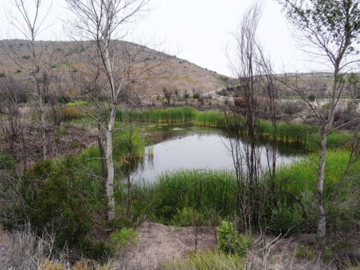
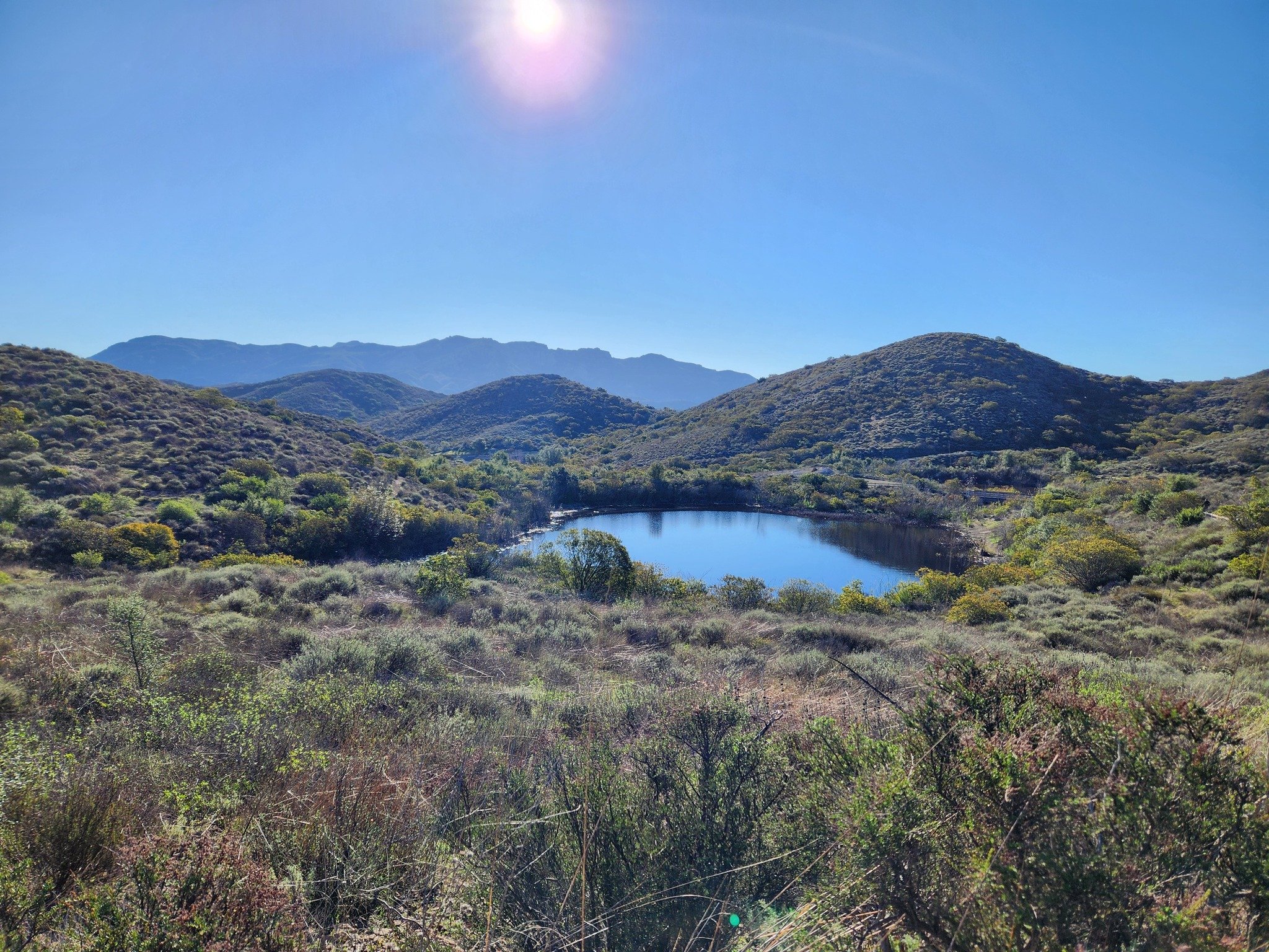
The Twin Ponds Conservation Area in Dos Vientos is part of the open space lands of the Conejo Open Space Conservation Agency and is protected by a conservation easement to the California Department of Fish and Game.

July 2014

July 2014

January 2015

January 2015

May 2016

May 2016

The ponds were originally constructed in the 1920s as part of the irrigation system for agricultural and cattle ranching operations at Dos Vientos Ranch. Today they serve as important habitat for Two Striped Garter Snakes and larger animals such as deer, bobcat, coyote and mountain lions that depend on a reliable source of water. Migrating waterfowl are occasionally abundant, especially in winter.

TwinPondsDV1.JPG

COSCA and Fish & Game ask that we enjoy this scenic area but protect the ponds for the future and ask that we do not enter the water or allow dogs/horses to enter the water, disturb or remove any animal or plant or place any plants or animals, including fish, into the ponds.

To explore the ponds, take the Vista Del Mar Trail from one of several access points in the Dos Vientos area, including the corner of Via Ricardo and Via Rincon and the corner of Rancho Dos Vientos and Via El Cerro. This is a fun little hike to take the kids on and the ponds are only about a mile from the Via Ricardo/Via Rincon trailhead.

Twin Ponds? What ponds? The ponds are completely dried up as of August/September 2016.

Twin Ponds? What ponds? The ponds are completely dried up as of August/September 2016.

January 2024

Late March 2024 - looking great!

State Route 23 Between the 101 and 118 is Dedicated to Japanese American World War II Soldiers

Moorpark Freeway section of SR 23 taken from Marview Trail in Thousand Oaks.

Moorpark Freeway section of SR 23 taken from Marview Trail in Thousand Oaks.

State Route 23 stretches from Malibu to Fillmore in three sections. The south section is the winding, hilly Decker Canyon Road that connects Pacific Coast Highway to Westlake Village and Hidden Valley. This section is approximately 10 miles from PCH to the Potrero Road intersection, but generally takes 20 to 25 minutes to drive.

SR 23 continues as Westlake Boulevard to the Ventura Freeway (U.S. Route 101), where it runs concurrent with the 101 north a couple miles until you reach the Moorpark Freeway overpass. This is another 4 to 4 1/2 miles.

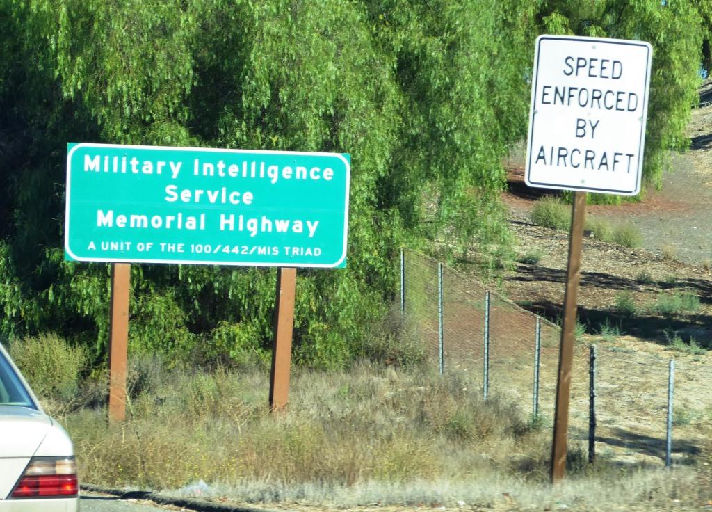
The most visible section of SR 23 in Thousand Oaks is the Moorpark Freeway, which stretches from the 101 to the Los Angeles Avenue exit in Moorpark; about 8 miles. This middle section of the 23 was named the Military Intelligence Service Memorial Highway in 1994 by the California State Assembly. The renaming was made in honor of Nisei, or Japanese American, Soldiers of World War II who served in units of the U.S. Armed Forces comprising the 100/442/MIS triad (Military Intelligence Service, 100th Infantry Battalion and 442nd Regimental Combat Team). **

Military Intelligence Service Memorial Highway sign

Military Intelligence Service Memorial Highway sign

The northern section of SR 23 begins at Los Angeles Avenue (SR 118) in Moorpark and goes north as Grimes Canyon Road, ending at SR 126 in Fillmore. This is about a 12 mile stretch includes some eye opening, hilly twists and turns in the Grimes Canyon Road area.

The total length of SR 23 is about 32 miles.

** Some additional clarification from the 1994 legislation: Segments of State Highway Routes 23 and 99 are officially designated as follows: (a) State Highway Route 23, from Highway 101 to Highway 118, as the Military Intelligence Service Memorial Highway. (b) State Highway Route 99, between the Cities of Fresno and Madera, as the 100th Infantry Battalion Memorial Highway. (c) State Highway Route 99, between the Cities of Salida and Manteca, as the 442nd Regimental Combat Team Memorial Highway. Each of the signs to also include "A unit of the 100/422/MIS triad.

Fireworks Hill in Thousand Oaks Has Hosted the City's Fireworks Show for Decades

So called "Fireworks Hill" is located in the center of Thousand Oaks, enveloped by McCloud Avenue on the northwest, St. Charles Drive on the northeast, Wilbur Road on the east, Marin Street on the south and Hillcrest Drive on the southeast.

The hill is passed by tens of thousands of commuters each day as it can clearly be seen from the 101. 

For decades, the annual City of Thousand Oaks 4th of July Fireworks have been launched from this hill, a 27 acre parcel that was acquired by the City of Thousand Oaks in 1994. According to an April 7, 1994 Los Angeles Times article, the top of the hill was graded three decades prior.

According to minutes from the April 5, 1994 City Council meeting, city council voted by a 3 to 2 vote to acquire the property from the Robert A. Franklyn Estate for $540,000, plus $5,000 in estimated escrow closing costs.

The fireworks launched from this site can be seen from quite a large radius in the surrounding area. Here's to a great Independence Day!

Independence Day events and activities throughout Ventura County

Fireworks Hill shown here in early January 2016, when three were snow capped peaks in the background.

Fireworks Hill shown here in early January 2016, when three were snow capped peaks in the background.

The Story Behind Those Historic El Camino Real Bell Markers on the 101 Freeway

Like me, perhaps you've wondered about those unique bell markers seen frequently on the 101 Freeway with the sign that says "Historic El Camino Real."

One of those ubiquitous Historic El Camino Real bell markers we see along the 101 Freeway.

One of those ubiquitous Historic El Camino Real bell markers we see along the 101 Freeway.

El Camino Real is Spanish for "The Royal Road" and in California is the name for the 700 mile historic California Mission Trail that connects 21 missions, 4 presidios (military forts) and several pueblos (towns) from Mission San Diego de Alcala in the south to Mission San Francisco Solano in Northern California. El Camino Real is designated as California Historical Landmark #784.

California State Assembly Bill 1707 defined the El Camino Real route, which includes portions of Routes 280, 82, 238, 101, 5, 72, 12, 37, 121, 87, 162, 185, 92, and 123 and connecting city streets and county roads in a continuous route from Sonoma southerly to the international border.

So what's up with those bell markers on the 101? According to the California Department of Transportation, the Mission Bell Marker system has existed on the historic El Camino Real route since 1906. The original marker system called for installation of bells one mile apart along the entire length of the El Camino Real. By 1913, over 450 markers were in place, but over the years the bells were removed due to damage, vandalism and theft. In 1959, the Division of Highways was legislatively mandated to maintain the marker system. Legislation in 1974 reiterated that responsibility.

Caltrans initiated a plan to maintain the system beginning in 1974, when less than 100 of the original Mission Bell Markers remained. The bells are exact copies of the original 1906 bells; in fact, the original bell molds were used to fabricate the new bells. Mission Bell Marker locations were chosen based on safety, constructability, visibility and scenic quality of the site. Spacing between marker locations varied based on existing site conditions and limitations. An average spacing of 1 to 2 miles was sought when identifying the locations.

The Caltrans Landscape Architecture Program began in 1996 to fulfill its vision to restore the historic El Camino Real Mission Bell Marker system from San Diego to Sonoma. The portion of the system from San Diego to Los Angeles was not addressed by the restoration project because those bells are mostly located on local streets outside of the State’s jurisdiction. The first phase of the restoration project, between Los Angeles to San Francisco, was completed in early 2005. The second and final phase of the restoration project was completed between San Francisco and Sonoma in late 2012. The Mission Bell Marker system as originally envisioned in the earlier part of the last century has finally been realized!

Caltrans received nearly $2 million in Transportation Enhancement grants to fund restoration of the Mission Bell Marker system on the El Camino Real from Orange County to Sonoma. Funding was received for the manufacture and placement of 585 Mission Bell Markers, placed approximately one to two miles apart along the roadside in the northbound and southbound directions of State Routes 101, 82, 37, 121, and 12. Mission Bell Markers located within the roadside of a state route are maintained by Caltrans. Maintenance of Markers located on local streets are the responsibility of the local entity.

So that explains why you see all of those interesting bell markers on the 101 Freeway! How would you like to have one of these authentic California El Camino Real Bell Markers in your own yard!? Visit the California Mission Bell company website at www.californiabell.com.

Older El Camino Real bell marker on display at the Old Mission Santa Barbara.

Older El Camino Real bell marker on display at the Old Mission Santa Barbara.