Mugu Rock at Point Mugu

Point Mugu is an unincorporated part of Ventura County that is derived from the Chumash word Muwu, or beach. Other than the Naval Base, probably the most well known fixture in Point Mugu is the Mugu Rock. Mugu Rock is a large rock formation that was formed when Pacific Coast Highway was built and cut through the mountain that now resides on the other side of PCH. Before PCH was built, a road went around the rock, where a chain link fence has been placed to keep people away from this hazardous area adjacent to the Pacific Ocean.  PCH was cut through Point Mugu from October 1937 to February 1940, according to this interesting KCET article.

MuguRock_pch.JPG

Mugu Rock is located just a few miles near the northwest tip of PCH before it veers north towards Oxnard. It is about a 10 mile drive from the Camarillo Premium Outlets and about 20 miles from the heart of Thousand Oaks taking either the 101/Lewis Road route or the slightly slower, curvy and interesting Potrero Road route.

Professional landscape and wildlife photographer Greg Clure of Newbury Park has shared a couple neat images facing Mugu Rock from the south. Visit Greg's website at www.gregclurephotography.com for more of his outstanding work.

ClureMuguRock2.jpg
ClureMuguRock1.jpg

And here is some not so professional video footage of Mugu Rock from the north.
A Bit of History Behind the Origination of the Conejo Valley Unified School District

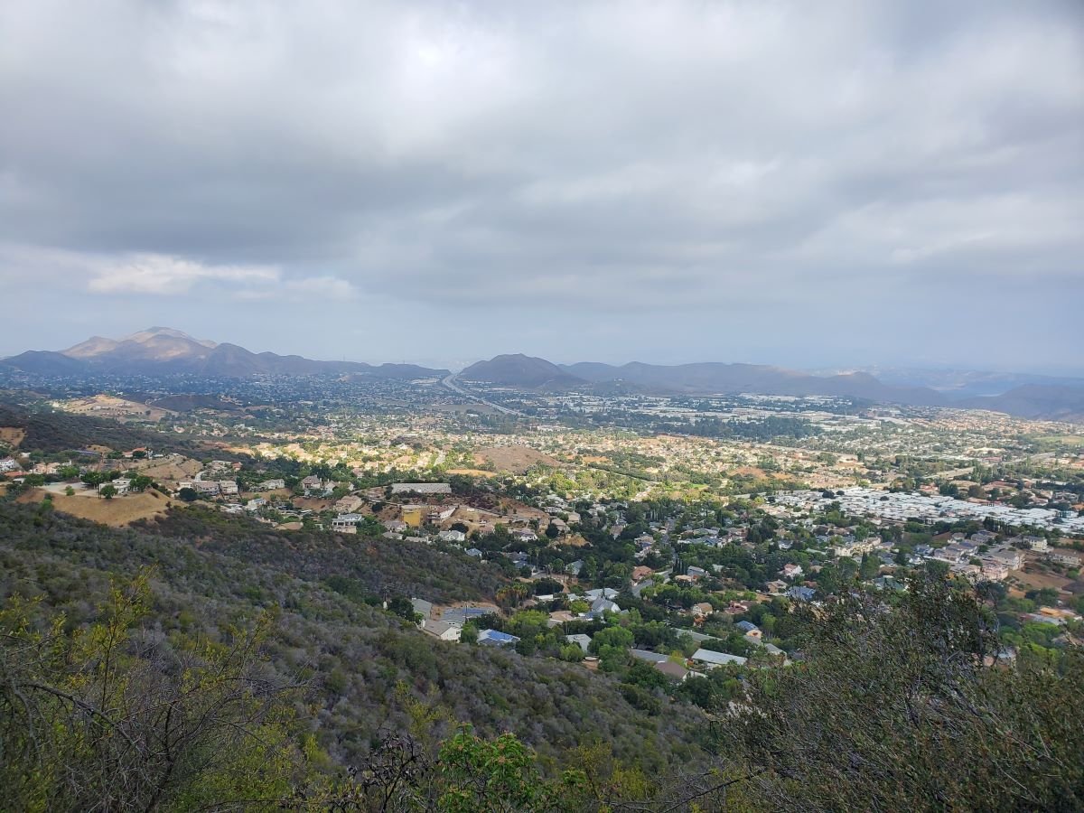
View of the Conejo Valley from the Los Robles Trail in Thousand Oaks

The Conejo Valley spans southeastern Ventura County and northwestern Los Angeles County. Communities in the Conejo Valley include Thousand Oaks, Newbury Park, Westlake Village, Oak Park, Agoura Hills, Lake Sherwood and a portion of Calabasas,

The Conejo Valley Unified School District was created July 1, 1974, unifying the following previous school districts:

  • Timber School District (founded in 1888)

  • Valley Oaks Union School District (founded in 1960 and formerly Conejo School District, founded 1877 and Santa Rosa School District, founded 1912).

  • Newbury Park and Thousand Oaks High Schools (formerly part of Oxnard Union High School District, founded in 1901).

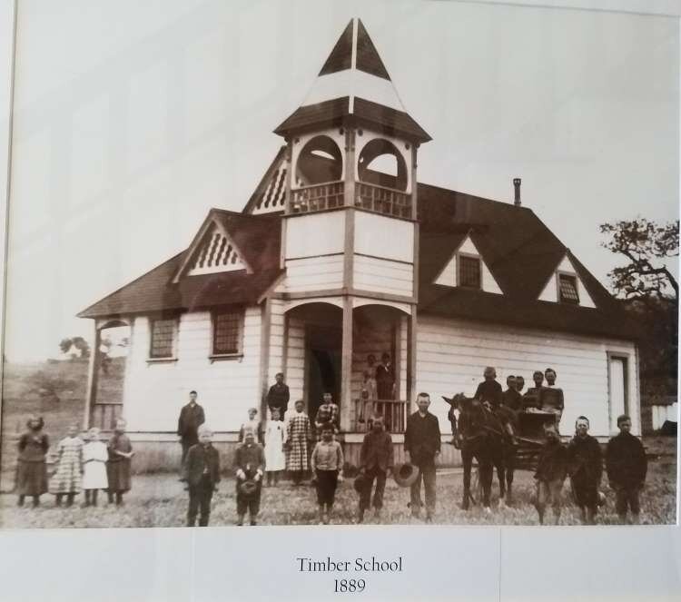
The Timber School was established as the first school in Newbury Park in 1889. The original school was constructed at the intersection of what is now Newbury and Kelley Roads in Newbury Park. The original Timber School was a one room schoolhouse that was demolished to make way for the new, larger Timber School House erected in front of the original school in 1924. The Timber School Auditorium was built in 1948.

The Timber School House and Auditorium buildings at 1872 Newbury Road, Newbury Park represent City of Thousand Oaks Landmark No. 12 and Ventura County Historical Landmark No. 166.

A replica of the original Timber School House was built at the Stagecoach Inn Museum complex in 1995 by students of Newbury Park High School under direction of teacher, Randy Porter.

Replica of the original Timber School at the Stagecoach Inn Museum.

Replica of the original Timber School at the Stagecoach Inn Museum.

Photo of the original Timber School in 1889.

Photo of the original Timber School in 1889.

Formed in 1877, the Conejo School District predates the Timber School District. It was created at a time when there were 126 residents in the Conejo Valley, including 54 children under age 17. After operating for 4 months in a shanty on the ranch of Howard Mills, parents voted to assess $750 for a building that was constructed on two acres of land donated by Mills. The structure was called “Conejo School” and was located near what is now the northwest corner of Westlake Boulevard and Townsgate Road.

As a result of the terrible drought in late 1870s to early 1880s, many ranchers had to leave the area. The Mills property was sold to the Russell family. Abigail Russell, wife of Andrew Russell, struggled to keep the Conejo School open. Eventually, a new Conejo School was built and opened in 1929 at the current location of Conejo Elementary School at 280 N. Conejo School Road in Thousand Oaks. The original school built in 1929 was demolished in 1957 due to unsafe earthquake standards.

Learn more about the Timber School and Conejo School districts on the Stagecoach Inn Museum website at stagecoachinnmuseum.com/timber-school.

Students at Conejo School in 1941 (Photo donated by Gerald Olsen to the Conejo Through the Lens collection, Grant R. Brimhall Library, Thousand Oaks).

Students at Conejo School in 1941 (Photo donated by Gerald Olsen to the Conejo Through the Lens collection, Grant R. Brimhall Library, Thousand Oaks).

Today, the Conejo Valley Unified School District in Ventura County serves Thousand Oaks and its communities of Newbury Park and the Ventura County portion of Westlake Village. As of spring 2025, the district is comprised of the following schools:

  • Four preschool/early child care schools: CVUSD Preschool - Early Childhood Program, Wonder Preschool, Horizon Hills Parenting Program, Be Me Preschool Program (play-based and language enriched program for ages 3 to 5 eligible for special education)

  • Eighteen elementary (K-5) schools: Acacia Magnet School for Enriched Learning, Aspen, Banyan, Conejo Academy of Leadership and Language Immersion, Cypress, EARThS Magnet, Glenwood, Ladera STARS Academy, Lang Ranch, Madroña Academy of the Arts and Sciences, Maple, SHINE Homeschool, Sycamore Canyon, Walnut, Weathersfield, Westlake, Westlake Hills, Wildwood

  • Eight middle schools: Century Academy, Colina, Los Cerritos, Outdoor School, Redwood, Sequoia, SHINE Homeschool, Sycamore Canyon

  • Six high schools: Newbury Park, Thousand Oaks, Westlake, Conejo Valley, Century Academy, SHINE homeschool

  • Homeschool and Hybrid Learning: SHINE: Homeschool Program (TK-12), Century Academy (grades 6-12)

  • Two Adult and Post-Secondary Programs: The Conejo Valley Adult Education, Conejo Oaks Academy (post-secondary program)

The Conejo Valley USD website is www.conejousd.org.

Century Lake at Malibu Creek State Park

According to the Malibu Creek Docents, around 1903, the Crags Country Club constructed a 50 foot tall dam on its 2,000 acre property on what is now Malibu Creek State Park. The dam created a seven acre lake that club members used for fishing and duck hunting.

The Club closed in 1936, and 10 years later, 20th Century Fox Studios purchased the property to film movies and TV shows on what was renamed Century Ranch. The 1968 "Planet of the Apes" featured many prominent scenes shot here.

This is an awesome video showing Planet of the Apes (1968) film scenes at Malibu Creek State Park and local area beaches then and today.

As for the lake, it is now referred to as Century Lake, a hiking destination in Malibu Creek State Park. Only 1 1/2 miles from the parking area, Century Lake is in a secluded area, where you can eat your lunch at the picnic table and enjoy serenity (usually, depending on who else is there). I believe it is fine to wade in the water and even kayak in there if desired. although I've never seen anyone do so.

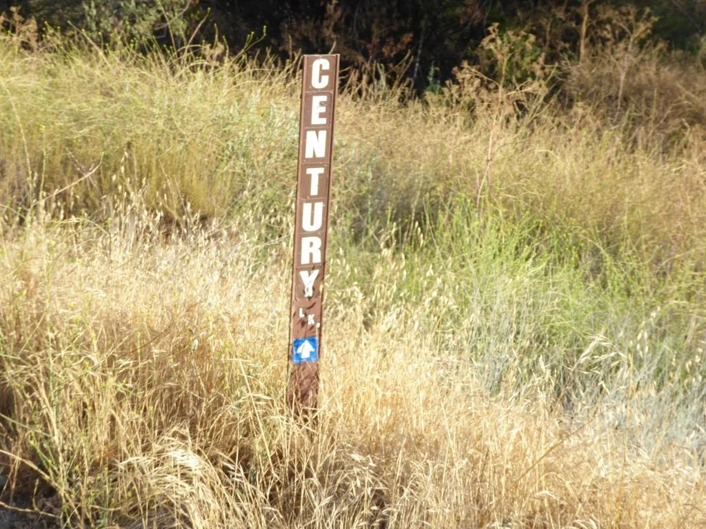
Century Lake is a left hand turn from the main Crags Road trail, after cresting the only significant hill going down the other side. The only indicator is this narrow sign.

Century Lake is a left hand turn from the main Crags Road trail, after cresting the only significant hill going down the other side. The only indicator is this narrow sign.

The hike has a moderately steep hill in it, but otherwise is quite flat and easy to do with kids and/or a stroller.

Malibu Creek State Park has something for everyone...camping, a visitor center, the "Rock Pool," the M*A*S*H set, the old Reagan Ranch, Century Lake, over 35 miles of trails, rock climbing (near the Rock Pool) and more.

The Century Dam is shown in this image. You don't wanna fall down that dam. Off limits.

The Century Dam is shown in this image. You don't wanna fall down that dam. Off limits.

The Saticoy Southern Pacific Railroad Depot is on the National Register of Historic Places

Saticoy Southern Pacific Railroad Depot seen from Alelia Ave

The Saticoy Southern Pacific Railroad Depot is located in the unincorporated community of Saticoy at 11220 Azahar Street.

The depot, built in 1887, was designated Ventura County Historic Landmark no. 176 in May 2016. It was listed on the National Register of Historic Places in 2018.

The depot was built by the Southern Pacific Railroad along the line that was being constructed from Los Angeles to Ventura in 1887. The original town of Saticoy was laid out near the new depot. Its name comes from the Chumash village of Sa’aqtik’oy. 

The Saticoy Depot served rail that traveled through the Santa Clara Valley between Saugus to Ventura County. It was one of 14 Southern Pacific Railroad Depots in Ventura County - the others were Oxnard, Santa Susana, Santa Paula, Fillmore, Piru, Ojai, Camarillo, Moorpark, Sespe, Camulos, Somis, Montalvo and downtown Ventura. Only six of these remain today.

Saticoy Depot in 1956 (Museum of Ventura County)

Ventura County Area Listings in the National Register of Historic Places

NationalRegisterHistoricPlaces.jpg

The National Register of Historic Places is the official list of the Nation's historic places worthy of preservation. Authorized by the National Historic Preservation Act of 1966, the National Park Service's National Register of Historic Places is part of a national program to coordinate and support public and private efforts to identify, evaluate and protect America's historic and archaeological resources.

There are over 80,000 listings in the National Register in five general categories: building, structure, site, district and object.

To be considered eligible for the Register, a property must meet the National Register Criteria for Evaluation. This involves examining the property’s age (generally at least 50 years old), integrity and significance.

To learn more about the National Register of Historic Places and to search its database, visit www.nps.gov/subjects/nationalregister/index.htm.

Now let's highlight Ventura County area properties listed in the Register as of November 2024. Most of these you can visit (links provided where applicable):

Other nearby historic places:

Tell Me About the History of the Street Names in Casa Conejo in Newbury Park

Casa Conejo is an unincorporated Ventura County community of about 1,000 homes located in Newbury Park. Casa Conejo is a rectangular shaped island within Thousand Oaks city limits, but is not part of the city. Although Casa Conejo is considered part of Newbury Park, it is not part of the majority of Newbury Park within the boundaries of the City of Thousand Oaks.

Casa Conejo Map.jpg

Premiering in 1960, Casa Conejo was the first planned community in Newbury Park. Several folks have asked about the origin of the street names in Casa Conejo. Here goes (with the help of a relative of the original developers):

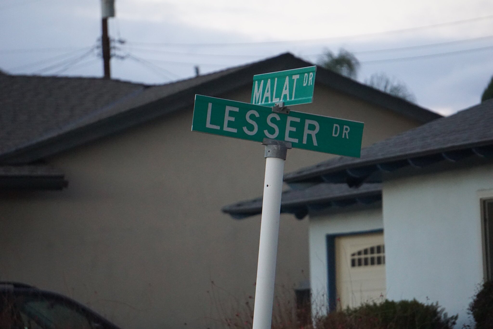
Louis Lesser Enterprises developed Casa Conejo. Members of the Lesser and Malat families created the street names; hence Lesser and Malat Drives, Rudman Drive came from Louis Rudman, also related through marriage to the Lessers, and who managed home sales.

malat and lesser.jpg
rudman and lesser.jpg

William Malat (William Drive) had twin sons, Melvin (Melvin Ct) and Gerald (Gerald Drive). William's wife was Ethel (Ethel Ct). Louis Lesser's wife was Jeanne (Jeanne Ct). Louis Lesser's brother, Alvin "Sonny" was married to Martha (Martha Dr). Louis Rudman's wife was Shirley (Shirley Dr), who was also Ethel’s sister. One of Sonny's daughters is Dena (Dena Dr).

dena and gerald.jpg

Ben (Ben Ct) and Lily (Lily Ct) were Louis and Alvin Lesser's parents. Michael (Michael Drive) is a cousin (by marriage) of the Lessers and Malats. Cathy (Cathy Dr) and Francine (Frankie Dr) were two of Louis and Jeanne’s four children. Lisa Rudman (Lisa Ct) is related to the Rudmans (I suspect their daughter).

The jackpot winner was WENDY, who has by far the longest street, not to mention a freeway on/offramp and overpass, named after her! Wendy, who lives in AZ, is a granddaughter of William Malat and daughter of Melvyn. Before it became Wendy Drive in mid-1961, it was called Avenida de la Felicidad.

There are a couple dozen other streets in Casa Conejo that I don’t have the source for at this time, but perhaps I’ll do some more digging:

North/South Streets: Jenny Drive, Gerst Drive, Ruth Drive, Lois Ave, Dorena Drive, Kitty St, Bella Dr, Randy Dr, Debbie St, Cay Ct, Henry Dr, Devia Dr, Virginia Dr, Nellie Ct, Bob Ct, Elinor Ct.

East/West Streets: Gloria Dr, Carl Ct, Alice Dr, Lynn Ct, Lois Ct, Verna Ave.

wendy drive.jpg

Historical and Cultural Landmark Grandma Prisbrey's Bottle Village in Simi Valley

BottleVillage1.JPG

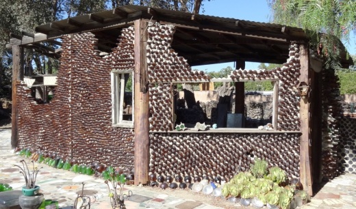
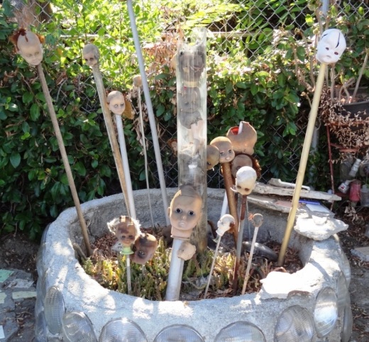
Grandma Prisbrey's Bottle Village in Simi Valley is a California Historical Landmark, Ventura County Cultural Landmark and is listed on the National Register of Historic Places.

Bottle Village is a .3 acre lot located at 4595 Cochran Street that contains shrines, walkways, sculptures and buildings made from recycled items and discards from local landfills. All of these structures were built by hand over a 25 year old period by Tressa "Grandma" Prisbrey, beginning at age 60 in 1956 until 1972. Thirteen buildings and 22 sculptures in total.

BottleVillage8.JPG

A non-profit organization, Preserve Bottle Village (PBV), was formed in 1979. The 1994 Northridge Earthquake caused extensive damage to the Bottle Village site. PBV has embarked on a campaign to develop a master plan for the restoration of significant site components. Learn how you can help at bottlevillage.weebly.com. There’s also a more recent website, with link to social media and periodic tours, at www.bottlevillage.org.

Grandma Prisbrey sold the property in 1972 to care for an ailing son, but came back several years later to continue building and to give tours.  She died in 1988 at the age of 92.

BottleVillage9.JPG
BottleVillage11.JPG
BottleVillage7.JPG
BottleVillage5.JPG