Ventura County Area Listings in the National Register of Historic Places
/
The National Register of Historic Places is the official list of the Nation's historic places worthy of preservation. Authorized by the National Historic Preservation Act of 1966, the National Park Service's National Register of Historic Places is part of a national program to coordinate and support public and private efforts to identify, evaluate and protect America's historic and archaeological resources.
There are over 80,000 listings in the National Register in five general categories: building, structure, site, district and object.
To be considered eligible for the Register, a property must meet the National Register Criteria for Evaluation. This involves examining the property’s age (generally at least 50 years old), integrity and significance.
To learn more about the National Register of Historic Places and to search its database, visit www.nps.gov/subjects/nationalregister/index.htm.
Now let's highlight Ventura County area properties listed in the Register as of November 2024. Most of these you can visit (links provided where applicable):
Anacapa Island Archeological District (listed 9/12/1979)
Anacapa Island Light Station (9/3/1991)
Elizabeth Bard Memorial Hospital, 121 N. Fir St, Ventura (11/11/1977)
Bardsdale Methodist Episcopal Church, 1418 Bardsdale Ave, Fillmore (8/28/1986)
Berylwood (Estate of Thomas R. Bard family owned by U.S. Navy and located at U.S. Naval Station Battalion Center in Port Hueneme) (9/15/1977)
Burro Flats Painted Cave, Bell Canyon (address restricted) (5/5/1976)
Calleguas Creek Site, Oxnard (address restricted) (5/19/1976)
Camarillo Ranch House (2/20/2003)
Case Study House No. 28, 91 Inverness Road, Thousand Oaks (Case Study Houses were experiments in American residential architecture from 1945 to 1966). (7/24/2013)
Colony House, 137 Strathearn Place, Simi Valley (9/18/1978)
Dudley House, 4085 Telegraph Road, Ventura (5/17/1977)
Ebell Club of Santa Paula, 125 S. Seventh St (7/20/1989)
George Washington Faulkner House, 14292 W. Telegraph Road, Santa Paula (4/25/1991)
Feraud General Merchandise Store, 2 and 12 W. Main St, Ventura (1/23/1986)
First Baptist Church of Ventura, 101 S. Laurel St (7/3/2009)
Emmanuel Franz House, 31 N. Oak St, Ventura (6/25/1982)
Glen Tavern Hotel, 134 N. Mill St, Santa Paula (7/26/1984)
Thomas Gould, Jr. House, 402 Lynn Drive, Ventura (12/23/2005)
Grand Union Hotel (now Stagecoach Inn Museum), 51 Ventu Park Road, Newbury Park (12/30/1975)
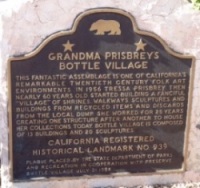
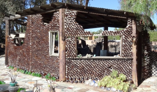
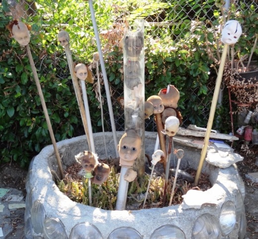
Grandma Prisbrey's Bottle Village, 4595 Cochran St, Simi Valley (10/25/1996)
Joel McCrea Ranch, 4500 N. Moorpark Rd, Thousand Oaks (4/18/1997)
Mission San Buenaventura, 211 E. Main St, Ventura (4/10/1975)
Olivas Adobe in Ventura (7/24/1979)
Carnegie Art Museum (formerly Oxnard Public Library), 424 S. C Street (7/27/1971)
Henry T. Oxnard Historic District, F & G Streets, between Palm & 5th (2/5/1999)
Charles M. Pratt House, 1330 Foothill Road, Ojai (6/14/2002)
Rancho Camulos, 5164 E. Telegraph Road, Piru (11/1/1996)
San Buenaventura Mission Aqueduct, 234 Canada Larga Rd., Ventura (3/7/1975)
San Miguel Chapel Site (address restricted), Ventura (7/20/1978)
Santa Paula Hardware Company Block--Union Oil Company (now California Oil Museum) 1003 E. Main St. (8/14/1986)
Saticoy Southern Pacific Railroad Depot, 11220 Azahar Street, Saticoy (7/23/2018)
Simi Adobe-Strathearn House,137 Strathearn Place, Simi Valley (5/19/1978)
SS Winfield Scott (Steamship shipwreck at Anacapa Island) (9/12/1988)
St. Thomas Aquinas Chapel (now Ojai Valley Museum), 130 W. Ojai Ave, Ojai (6/29/1995)
Thacher School Historic District, 5025 Thacher Road, Ojai Valley (4/4/2019)
Ventura County Courthouse (now Ventura City Hall), 501 Poli St, Ventura (8/19/1971)
Ventura Theater, 26 S. Chestnut, Ventura (12/29/1986)
Women's Improvement Club of Hueneme, 239 E. Scott St (8/21/1989)
Other nearby historic places:
Adamson House, 23200 W. Pacific Coast Highway, Malibu (10/28/1977)
Humaliwo (address restricted) (9/1/1976)
Saddle Rock Ranch Pictograph Site (address restricted) (2/12/1982)
Stevens House, 23524 Malibu Colony Road, Malibu (10/9/2009)
Leonis Adobe, 23537 Calabasas Road, Calabasas (5/29/1975)