Voters Chose to Incorporate the City of Thousand Oaks Over the City of Conejo in a September 29, 1964 Special Election
/
On September 29, 1964, voters in the Conejo Valley were given the choice of whether to incorporate as a separate city in Ventura County and, if so, what to name this new city. It came down to 4,601 out of approximately 7,000 registered voters that Tuesday.
In March 1963, 27 local organizations gathered to form a Conejo City Committee to take steps to bring to a public vote the incorporation of the City of Conejo.
Conejo? Yes, Conejo. A 16 square mile city. There was plenty of controversy, since the name Thousand Oaks had been used for much of this area within the Conejo Valley for over 40 years.
A group of citizens successfully petitioned to add the name Thousand Oaks to the ballot as an alternative to Conejo.. A humorous example of some of the outrage over changing the name to Conejo is seen in this letter to the editor of the local Chronicle newspaper:
"Let's Not Drop Thousand Oaks" Conejo in Spanish means rabbit, and since talk has it to change our name to Conejo instead of our good old Thousand Oaks, I then suggest we cut down all our beautiful oak trees and replace each one with a nice fat rabbit so that we can identify ourselves with the strange new name which some newcomers have thrown at us without regard or consideration of our sentimentality and perhaps foolish tradition. If one lives in the San Fernando Valley in Canoga Park or Northridge, one says he lives in Canoga Park or Northridge in San Fernando Valley. So why can't we say we live in Thousand Oaks in the Conejo Valley or in Newbury Park in Conejo Valley. I don't care how we do it, just please let's not drop the name of Thousand Oaks." -Lucia Rios de Schneider, 3107 Radcliffe Road, Thousand Oaks
There were also a number of residents who did not want to be included in the incorporation initiative, including residents of Newbury Park, residents of the Rolling Hills area south of the 101, 500 acres of Janss Corporation owned land west of Cal Lutheran, 40 acres of land east and south of the Park Oaks Shopping Center and 100 acres of land south of the 101 owned by Louis Goebel.
Election Results - A City is Born
The Special Election for the Incorporation of the City of Conejo took place on Tuesday, September 29, 1964. Voting was a lot simpler back then. Instructions indicated to vote, "stamp a cross (+) in the voting square next to the right of the answer you desire to give." "On absent voter ballots mark a cross (+) with pen or pencil." The three measures submitted to vote were:
For or against incorporation
The proposed city should be named (vote for one): Conejo or Thousand Oaks
Vote for five city council members if the city is incorporated (there were 37 candidates on the ballot)
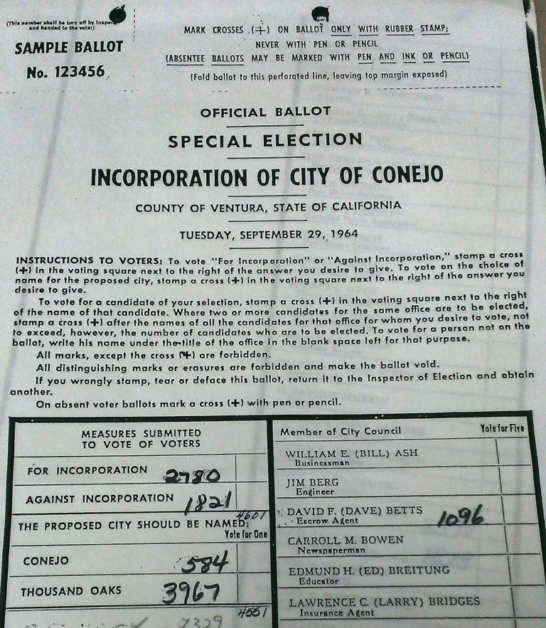
Portion of Sample Ballot from the September 29, 1964 Special Election for the Incorporation of City of Conejo (or Thousand Oaks, as the case were to be) (Courtesy Thousand Oaks Library Special Collections)
As you can see from the tallies written on the sample ballot above, residents voted to incorporate the city, but at 60% of the 4,601 votes it was not exactly a landslide. However, the desire to retain the name Thousand Oaks was quite clear, as 87% of votes tallied for this name over the city of Conejo.
The first City of Thousand Oaks City Council consisted of pharmacist Robert Talley (2,598 votes), Ventura County planner John Tapking (1,574 votes), Accounting Chief Alexander Fiore (1,139 votes), escrow agent David Betts (1,096 votes) and engineer Lee Williams (1,056 votes).

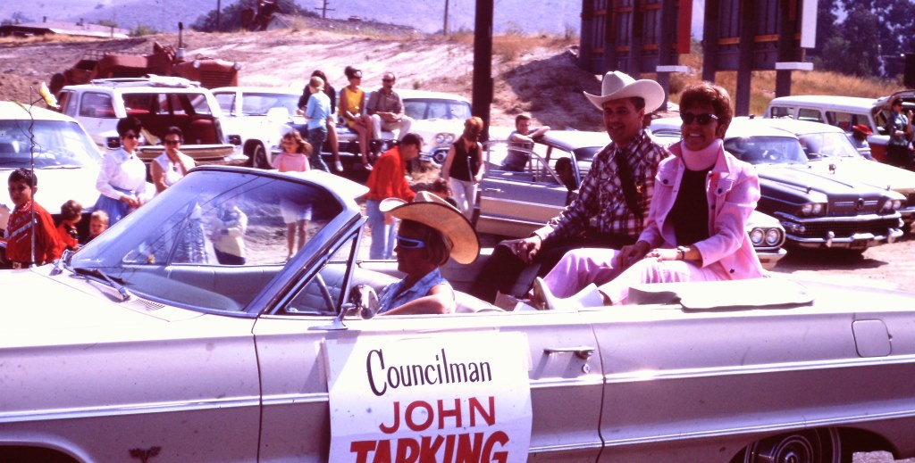
Councilman and Thousand Oaks Mayor David Betts in the 1966 Conejo Valley Days parade.
Another one of the original city of thousand Oaks councilmembers, John Tapking.
The City of Thousand Oaks was officially incorporated on October 7, 1964. At the time, the population of the city was approximately 22,000. The U.S. Census estimates 2014 population at just over 129,000. The City turned 50 in 2014.
Where Did the Name "Thousand Oaks" Come From?
According to the late Pat Allen, historian for the city, mostly farmers lived in the Conejo Valley in 1922. The 2,200 acre Crowley Ranch was sold and subdivided and lots were sold for $1,000. As lots sold and population grew, developers held a contest to name the new village. Sixteen year old Bobby Harrington entered the name "Thousand Oaks," he won the prize and the rest is history.
Thousand Oaks became a subdivision of Ventura County on May 1, 1923, as recorded by the County Recorder. The Thousand Oaks post office opened October 31, 1938 (compared to July 16, 1875 for the Newbury Park post office).
Sources: Thousand Oaks Library Special Collections and news articles from the Conejo News, The Chronicle and Oxnard Press Courier.