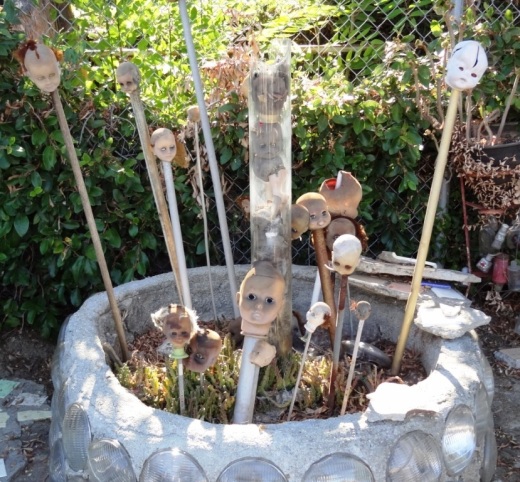
Historical and Cultural Landmark Grandma Prisbrey's Bottle Village in Simi Valley

BottleVillage1.JPG

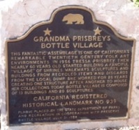
Grandma Prisbrey's Bottle Village in Simi Valley is a California Historical Landmark, Ventura County Cultural Landmark and is listed on the National Register of Historic Places.

Bottle Village is a .3 acre lot located at 4595 Cochran Street that contains shrines, walkways, sculptures and buildings made from recycled items and discards from local landfills. All of these structures were built by hand over a 25 year old period by Tressa "Grandma" Prisbrey, beginning at age 60 in 1956 until 1972. Thirteen buildings and 22 sculptures in total.

BottleVillage8.JPG

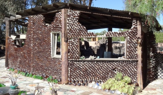
A non-profit organization, Preserve Bottle Village (PBV), was formed in 1979. The 1994 Northridge Earthquake caused extensive damage to the Bottle Village site. PBV has embarked on a campaign to develop a master plan for the restoration of significant site components. Learn how you can help at bottlevillage.weebly.com. There’s also a more recent website, with link to social media and periodic tours, at www.bottlevillage.org.

Grandma Prisbrey sold the property in 1972 to care for an ailing son, but came back several years later to continue building and to give tours.  She died in 1988 at the age of 92.

BottleVillage9.JPG
BottleVillage11.JPG
BottleVillage7.JPG
BottleVillage5.JPG

Hillside Letters in the Conejo Valley and Greater Ventura County

There are over 500 hillside letters, or “mountain monograms,” in the United States, including 81 in California. What are hillside letters, you ask. They are simply large single letters, abbreviations and sometimes even messages erected on a hillside, usually by a school or town.

The Big “C” overlooking UC Berkeley (From Wikipedia; public domain)

The Big “C” overlooking UC Berkeley (From Wikipedia; public domain)

One well known hillside letter is a giant concrete block letter “C” built in the hills overlooking UC Berkeley that was constructed on March 23, 1905.

We have our share of hillside letters here in the Conejo Valley and Greater Ventura County, some of which you may be aware of…others, perhaps not.

The mountain monograms visible in our neck of the woods include:

The letters CLU on Mt. Clef Ridge above Cal Lutheran University are maintained by students.

Hilltop A overlooking Agoura High School up a steep hill. Made out of wood, I believe.

Here is a view of the letter VC north of Ventura College in late April 2019.

Here is a view of the letter VC north of Ventura College in late April 2019.

If you drive north up Catalina Street, west of Ventura High School, you will be able to see this letter V on the hillside.

The letter F is located in the hills west of Fillmore and is quite easy to see.

This letters SP letters in the hills south of Santa Paula is cleared brush. They originated in 1922. More information on THIS PAGE.

Happy Face Hill in Simi Valley is not a mountain monogram but is perhaps the visible hillside attraction throughout Ventura County.

The Carpinteria Tar Pits are One of Five Natural Asphalt Lake Areas in the World

The Carpinteria Tar Pits at Carpinteria State Beach are located in a designated area called Tar Pits Park. The Carpinteria Tar Pits are one of five natural asphalt lake areas in the world, 2nd in size to and older than the La Brea Tar Pits in Los Angeles.

These tar pits date back to the Pleistocene Age (Ice Epoch), which 2.6 million to 11,700 years ago. Evidence of imperial elephants, the giant sloth, bison, wolf, tusked mastodons and camels have been discovered in t

Read More

Five Notable Historical Sites and Places to See in and Around Ventura County

In the mid 1850s, the area that we call Ventura County was the southern part of Santa Barbara County.  By 1873, Ventura County officially split off from Santa Barbara County and by the turn of the century the cities of San Buenaventura (or Ventura as we know it), Port Hueneme, Santa Paula, Nordhoff (now Ojai), Simi, Somis, Moorpark and Oxnard came on board. Camarillo and Thousand Oaks were late bloomers, incorporating in 1964.

There are hundreds of historical things to see around Ventura County, dozens of which are covered here on Conejo Valley Guide. Let's take a look at five neat places to see Ventura County history to additional information.

Strathearn Historical Park and Museum in Simi Valley has a notable collection of structures and artifacts from Simi's early days. The park is jointly operated by the Rancho Simi Recreation and Park District and Simi Valley Historical Society.

Strathearn3.JPG
AgricultureMuseum.jpg

The Museum of Ventura County opened its Agriculture Museum in Santa Paula in September 2011. The museum is housed in the historic 1888 restored mill building. In its 12,000 sq ft, you'll find an extensive collection of vintage farm equipment, tools, machines, clothing, photos and artifacts.

Probably my personal favorite local historical venue, just outside the Ventura County border, is the Leonis Adobe Museum in Calabasas, adjacent to Sagebrush Cantina. If you've never been there, do stop by and bring the kids, as you'll be amazed at how much there is to see in this somewhat hidden location. The kids will love visiting with the collection of farmyard animals, there are lots of historical artifacts, including quite an impressive collection of vintages wagons/carriages and much more.

Bull-ying can be a good thing...at the Leonis Adobe in Calabasas.

Bull-ying can be a good thing...at the Leonis Adobe in Calabasas.

Bull-ying can be a good thing...at the Leonis Adobe in Calabasas. Fun to watch.

ranchhouse.jpg

The Camarillo Ranch House is a 6,000 sq ft Victorian home built by Adolfo Camarillo, son of city namesake Juan Camarillo, in 1892. The house is owned by the City of Camarillo and the nonprofit Camarillo Ranch Foundation maintains the property, which has been restored to look how it looked in the 1904 to 1930 time frame. Take a docent-led tour of the house and enjoy one of the most beautiful venues for outdoor weddings and events in Ventura County...immaculate grounds and stunning, mature trees at this peaceful location that is right off the 101.

Stagecoach Inn front web.jpg

Last but not least is the Stagecoach Inn Museum in Newbury Park, home to a replica of the 1876 Grand Union Hotel. Take a docent-led tour, check out the quaint gift shop and tour the grounds, which includes a Chumash Indian village, rose garden, nature trails and more. The site is home to a historic Sycamore Tree that is over 250 years old. Adjacent to the museum is a park with some uniquely designed playground equipment.

For hundreds and hundreds of things to do, check out the Do Something section of CVG.

M*A*S*H Site at Malibu Creek State Park

Malibu Creek State Park is a wilderness wonderland, stretching over 8,000 acres in Calabasas, Agoura and Malibu. The park is a great place for hiking, biking, camping, picnicking and exploring. If you do plan to explore the park, be sure to check out the old M*A*S*H (or "MASH" television series set!

MalibuCreek_Mash1.jpg

Produced by 20th Century Fox, M*A*S*H was filmed from September 1972 to February 1983 over 11 seasons and 256 episodes on CBS. Exterior scenes were filmed at what is now Malibu Creek State Park. Over the years, the ambulance and other props left at the old site became less and less visible as the surrounding brush became overgrown.

In 2007, the set was restored with a shaded picnic area, military vehicles, ambulance, helipad and signpost. Check out the photos below, but, better yet, visit it in person! For more pictures and extensive information about the M*A*S*H set and Malibu Creek State Park, visit www.malibucreekstatepark.org.

MASH_sign.jpg

The M*A*S*H site is easily accessible from the main parking lot at Malibu Creek State Park, mostly on wide fire roads, with one significant hill, a bridge crossing and one somewhat rocky trail section. The path is about 2 1/2 miles each way, so it would be a good idea to bring drinks and snacks.

MalibuCreek_Mash2.JPG
MASH_3.JPG
MASH_4.JPG
MashSite4.JPG
MashSite6.JPG

Evolution of the Conejo Grade in Ventura County Over the Last 100 Years

Horseshoe shaped section of the Conejo Grade in the 1920s.

Horseshoe shaped section of the Conejo Grade in the 1920s.

The Conejo Grade is the section of Highway 101 that connects the Conejo Valley with Camarillo. It is a four mile stretch of freeway with a significant 7% grade.

Going down the Conejo Grade from Newbury Park to Camarillo today.

Going down the Conejo Grade from Newbury Park to Camarillo today.

At 3:30 p.m. on the afternoon of May 1, 1937, a newly upgraded and realigned Conejo Grade premiered after a day of celebration commencing at the ranch of Adolfo Camarillo. Camarillo, the namesake of what in 1964 became the City of Camarillo, donated the right of way to enable the grade to be realigned. Actor Leo Carrillo entertained guests at Camarillo's ranch at the bottom of the grade.

Grand opening of the newly realigned Conejo Grade on May 1, 1937.

Grand opening of the newly realigned Conejo Grade on May 1, 1937.

The old Conejo Grade was constructed by the California Highway Commission in 1914-1915. The previous route had 49 twists and turns, making it somewhat hazardous to drive (albeit somewhat less steep than the current grade). The newly aligned Conejo Grade cut the number of curves by 75%.

Another view of the Conejo Grade before it was realigned in 1937.

Another view of the Conejo Grade before it was realigned in 1937.

The new 1937 Conejo Grade cost a total of $570,000, which is less than the average cost of a house in the Conejo Valley today! Over a year and a half, the project employed about 100 workers who put in over 272,000 hours, excavating over 800,000 cubic yards of mostly hard rock. Talk about rock stars!

In the 1950s and 1960s, Caltrans further widened and improved Highway 101 over the Conejo Grade.

In the 1950s and 1960s, Caltrans further widened and improved Highway 101 over the Conejo Grade.

Several decades later, as Ventura County grew and the cities of Camarillo and Thousand Oaks incorporated in 1964, Caltrans continued to widen and improve the highway to what it is today.

ConejoGrade2014_2.jpg

Source for historical information: "California Highways and Public Works" (May 1937) - official journal of the State of California Division of Highways, Department of Public Works.

Special thanks to the Pleasant Valley Historical Society for providing historic photos.

Then and Now: The Dairy Farm at Camarillo State Hospital

In 1932, the State of California purchased 1,760 acres of the Lewis Ranch and built the Camarillo State Mental Hospital, which operated from 1936 to 1997 and at one point treated as many as 7,000 patients in the mid 1950s.

Located on the parcel was a dairy farm that produced crops and housed livestock that fed the hospital community. The farm was disbanded in the 1960s and has been left in a state of disrepair, falling prey over the decades to vandals and coined "Scary Dairy."

Here are some "then and now" photos of the most prominent elements of the dairy farm.

The hay barn at Camarillo State Hospital in the 1940s (CSUCI John Spoor Broome Library historic photo collection)

The hay barn at Camarillo State Hospital in the 1940s (CSUCI John Spoor Broome Library historic photo collection)

The hay barn today.

The hay barn today.

The dairy at Camarillo State Hospital in the mid-1950s. (CSUCI John Spoor Broome Library historic photo collection)

The dairy at Camarillo State Hospital in the mid-1950s. (CSUCI John Spoor Broome Library historic photo collection)

The dairy building today, fenced off, covered with graffiti. 

The dairy building today, fenced off, covered with graffiti. 

Inside the hay barn - undated photo. (CSUCI John Spoor Broome Library historic photo collection)

Inside the hay barn - undated photo. (CSUCI John Spoor Broome Library historic photo collection)

Inside of hay barn - more recently.

Inside of hay barn - more recently.