Geological Wonders at Vasquez Rocks Natural Area Park in Agua Dulce

If you're ever driving California State Route 14 (Antelope Valley Freeway) on your way to the high desert, you'll probably notice amazing rock foundations north of the freeway in Agua Dulce and freeway signs that indicate Vasquez Rocks.

VasquezRocks_sign.JPG

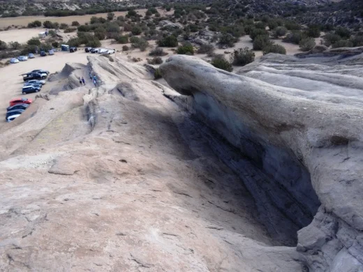
The 932 acre Vasquez Rocks Natural Area Park, owned and managed by the County of Los Angeles, contains ancient rock sculptures created by 20 to 25 million years of earthquake movement along the Elkhorn Fault, an offshoot of the San Andreas Fault.

VasquezRocks1.JPG

The ancient rock layers have slowly been compressed, folded and tilted while erosion has gradually stripped away the soil around the rocks, leaving spectacular jetting slabs. The large rock outcroppings are sandstone beds with areas of shale, basalt and reddish brown layering, sitting at angles of as much as 50 degrees, sweeping up to a peak of nearly 150 feet high.

VasquezRocks2.JPG
VasquezRocks3.JPG

Although habitation of the area goes back to the Tataviam Indians from 2000 B.C. to the late 1700s, the land has been named after a bandit named Tiburcio Vasquez, who used the rocks to escape from sheriff's posses. Vasquez Rocks may well be the only park in the world named after a notorious bandit who was ultimately caught and hanged.

VasquezRocks5.JPG

The park is a popular hiking, picnicking and equestrian area and has been used in many hit movies, television shows and commercials. A sampling of productions filmed at Vasquez Rocks include The Flintsones (movie), Planet of the Apes, Dracula (1931), Blazing Saddles, Austin Powers, Little Miss Sunshine, Power Rangers, Star Trek and many more.

VasquezRocks4.JPG

Located at 10700 W. Escondido Canyon Road in Agua Dulce. Take the Agua Dulce Canyon Road exit from the 14 and follow the signs. When you pull into the park, there will be an Interpretative Center with educational displays and a small gift shop on the right. Turn left on the dirt road to get to parking near the rock formations. The Interpretive Center is open Tuesday – Sunday 8:00am to 4:00 pm. Closed Mondays, except holidays.

Visit parks.lacounty.gov/wps/portal/dpr/Parks/Vasquez_Rocks_Natural_Area or call 661.268.0840 for more information. Vasquez Rocks is about an hour drive from Thousand Oaks and 35 to 40 minute drive from the eastern end of Simi Valley.

Britney Spears Posts Photo of Herself and Boyfriend at Popular Thousand Oaks Trail

Yesterday around 1:30pm, Britney Spears Tweeted a photo of herself and boyfriend Sam Asghari on a popular local trail destination in the Conejo Valley. This particular location tends to get overwhelmed with traffic, which causes problems for local residents. But there are dozens and dozens of outstanding trails in the Conejo Valley and surrounding areas compiled on THIS PAGE. Britney, if you are following this site, I challenge you to post a photo of yourself on five other Conejo Valley trails, perhaps including Angel Vista Peak, Space Mountain on the Los Robles Trail, the Lang Ranch/Woodridge Open Space, Sunset Hills Trail and the Hillcrest Open Space.

Britney mentioned in her Tweet that she has been with fitness model and aspiring actor Asghari for over a year. We can almost confirm that based on her Tweet 11 months ago showing the two of them in that same overly popular local hiking area.

And Asghari posted the same photo on his Instagram page, where he currently has 519K followers.

Thousand Oaks Community Park Has Several Unique Features Worth Exploring

Thousand Oaks Community Park, located at 2525 N. Moorpark Road, just north of Thousand Oaks High School, has something for everyone. This large, park is home to the Thousand Oaks Community Center, a hub for year-round events and activities for all ages. The center has a full-size gym, several fully-enclosed racquetball courts and other great features. More info at www.crpd.org/parkfac/1koaks.

TOCommCenter.JPG

If you have young kids, probably the most popular feature of this park is the playground and adjoining "Ant Hill." The Ant Hill is a unique, small man-made hill covered with artificial grass that is a fun play slide area for the kids. Bring a piece of cardboard and enjoy the ride.

AntHillApr04_1.JPG
AntHillApr04_2.JPG
TOCommPark_Playground.JPG

This nearly 36 acre park also has soccer and softball fields, four tennis courts, one sand volleyball court and plenty of picnic area. Both the park and the community center are popular for birthday parties. On the east side of the park is another unique feature you won't find in other parks, the Rabbit Flats Disc Golf Course. I connected with a group enjoying a Saturday round on this nine acre course and learned that there are specialized discs for disc golf.

RabbitFlatsApr04_1.JPG
RabbitFlatsApr04_2.JPG

The course is free to the public. I'd recommend a walk-through first to explore. Just be mindful of flying discs!

View From Grant Park in Ventura and Serra Cross in January 1956

Panoramic view from Grant Park in Ventura in three photos taken in January 1956.

Panoramic view from Grant Park in Ventura in three photos taken in January 1956.

Here's a panoramic view from Grant Park in Ventura taken in January 1956. Shortly after Father Junipero Serra founded Mission San Buenaventura, a large wooden cross was placed on top of the hill overlooking the Mission church.

The original cross, damaged over time by the elements, was replaced in the 1860s. That cross blew down in a storm on November 5, 1875 and was not replaced for 40 years.

The cross at Grant Park / Serra Cross Park in 2015.

The cross at Grant Park / Serra Cross Park in 2015.

A new wooden cross was placed by a local women's service club on September 9, 1912. In 1918, Kenneth and Tonie Grant donated the surrounding hillside to the City of San Buenaventura. Roads to the cross were built around 1920. The circular stone pedestal and concrete pathway the cross now sits atop was built in March 1932. The cross that sits there today, a bit charred from the Thomas Fire, was replaced by the city in 1941.

The Serra Cross Conservancy is seeking donations at www.gofundme.com/serracrosshelp to help restore the cross and surrounding property.

Serra Cross in January 1956, from a private collection.

Serra Cross in January 1956, from a private collection.

Fran Pavley Meadow in the Liberty Canyon Wildlife Corridor in Agoura Hills

PavleyMeadowSign.JPG

In November 2016, the Mountains Recreation and Conservation Authority and the Santa Monica Mountains Conservancy announced it was purchasing the 71 acre Chesebro Meadow property in the Liberty Canyon Wildlife Corridor in Agoura Hills.

It was named the Fran Pavley Meadow, after the State Senator and former City Councilmember and Mayor of Agoura Hills.

PavleyMeadow.JPG

This property will provide key connectivity to a proposed wildlife crossing over the 101 freeway in Agoura Hills.

The 71 acres supports a mix of chaparral, coastal sage scrub, grassland and oak woodland-savannah vegetation.  It connects to the Cheeseboro Canyon open space managed by the National Park Service (and yes, we have Chesebro and we have Cheeseboro, a spelling mystery that I've never received a clear answer on!).

To get there, take Chesebro Road towards Cheeseboro Canyon and you'll see the sign on the right. Park off street or at the nearby Cheeseboro Canyon trailhead parking lot, which has plenty of spots and is adjacent to the meadow.  You can also hike into Cheeseboro Canyon but take the path south (right) at the first fork in the trail.

You can park here at the Cheeseboro Canyon trailhead parking lot and either take this path into the canyon, to the fork, the veer right towards the meadow area, or you can walk down Chesebro Road to the Fran Pavley Meadow sign, then take the trail b…

You can park here at the Cheeseboro Canyon trailhead parking lot and either take this path into the canyon, to the fork, the veer right towards the meadow area, or you can walk down Chesebro Road to the Fran Pavley Meadow sign, then take the trail back for a couple mile loop.

You say Chesebro, I say Cheeseboro. It's all good!

You say Chesebro, I say Cheeseboro. It's all good!

Photos From Janss Conejo Ranch in 1960-1961 in What is Now Wildwood Park

6274WildwoodMovieRanch7-30-1961WaltDibblee.jpg

In the 1930s to 1960s, a number of TV shows and movies were filmed in what is now Wildwood Park, like Gunsmoke, The Rifleman, Spartacus and Wuthering Heights. Steve Dibblee of Ventura Views has provided these shots taken by his father, Walt Dibblee, of a western ranch town in Wildwood Park in 1960-1961.

You can see the same, familiar Mountclef Ridge in Wildwood Park today

You can see the same, familiar Mountclef Ridge in Wildwood Park today

Steve indicated the above photo shows The Rifleman's house and barn. It may also have been used in "The Man Who Shot Liberty Valance."

Steve indicated the above photo shows The Rifleman's house and barn. It may also have been used in "The Man Who Shot Liberty Valance."

And here is a bit of a depressing scene at the ranch on September 28, 1960.

And here is a bit of a depressing scene at the ranch on September 28, 1960.

View more of Walt's Ventura County area photography, including an extensive collection of aerials from the mid 1950s to the late 1960s, at VenturaViews.com.

Christmas Residential Holiday Light Display on Gemini/Waverly in Camarillo

As in many Christmas seasons past, homes on Gemini Avenue and Waverly Avenue south of Dunnigan Street in Camarillo are decked out with cartoon characters, trains, Santa, snowmen, and plenty of lights and other decorations this 2017 holiday season.

Drive the route or park and walk any night of the week. It is worth going out of your way for! From the the 101, take Arneill north past Ponderosa to Dunnigan. Turn right on Dunnigan and Gemini is the 4th street on your right. We've been stopping by this familiar display for years. 

CamHolLights2014_2.jpg
CamHolLights2014_3.jpg
Fun to see during the day too!
CamHolLights2014_4.jpg