The Smallest Post Office in the United States Used to Be in Wheeler Springs, Near Ojai

The Smallest Post Office in the U.S. that used to reside at 16850 Maricopa Highway was destroyed by the Thomas Fire in 2017.

We were in Ojai and decided to drive up Maricopa Highway to check out the Wheeler Gorge Visitor Center for the first time. It is a small building that provides information about the Los Padres National Forest staffed with volunteers who sell maps, trail guides, Adventure Passes and other items. Located at 17017 Maricopa Highway, about eight miles from the "Y" intersection where if you continue right you are headed into Ojai. The Wheeler Gorge Campground is nearby.

More on local campgrounds in and around Ventura County at THIS LINK.

More on local campgrounds in and around Ventura County at THIS LINK.

About a mile and a half before reaching the Visitor Center, at 16850 Maricopa Highway, we stopped at a small structure, shown above, that says "U.S.A.'s Smallest Post Office - Wheeler Springs, California." (NOTE: THIS STRUCTURE WAS DESTROYED IN THE THOMAS FIRE OF 2017.)

There's quite a bit of history behind that structure and others in the area. According to OjaiHistory.com, the Wheeler Springs Post Office was installed by Webb Wilcox next to his Webb Wilcox Cafe in the mid-1930s after the Maricopa Highway was built, connecting Ojai to Kern County. The "glorified shack" was was designated by Ripley's Believe it or Not as the smallest Post Office in the U.S.A. until Wilcox died in 1962 and Wheeler Springs lost its status as a U.S. Post Office.

Webb Wilcox was the son-in-law of Wheeler Blumberg, who founded Wheeler's Hot Springs in 1891. Wheeler's Hot Spring Springs for awhile was a successful resort, with 14 guest cabins, swimming pool, fishing, camping, hot springs-fed swimming pool and more.

Blumberg went a bit crazy in May 1907, locking himself in a room and shooting holes through the walls. A posse was able to capture Blumberg, sedate him and place him in a straitjacket in a padded cell in Ventura. He continued screaming and straining until he died "from utter exhaustion" the next day at age 43. Wilcox, who previously married Blumberg's daughter, Etta, took control over the resort and renamed it Wheeler Hot Springs.

Wheeler Hot Springs went through a number of ownership changes over the years, including radio/TV personality Art Linkletter at one point, who opened a "Kiddie Land" attraction, who did not do well financially there. Over the decades, the resort survived and was rebuilt after multiple fires, and the "great flood of '69" but finally was completely closed down in 1999.

Visit THIS LINK on the OjaiHistory.com website for a much more detailed, fascinating account of Wheeler Hot Springs' ownership challenges over the years..

The Wheeler Hot Springs property is located at 16825 Maricopa Highway and according to Zillow.com was most recently sold in October 2016. It is privately owned and not open to the public but you will get a small glimpse of it as you drive by. According to the Zillow listing, Wheeler Hot Springs is 84.5 acres and has five known natural hot and cold mineral springs and a year-round creek. There is a large farmhouse occupying the center of the property.

Over 25 Things to Do in Agoura Hills

Agoura Hills Sign.JPG

The City of Agoura Hills incorporated in 1982 and is part of Los Angeles County. But we consider Agoura to be part of our family, consisting of Thousand Oaks, Newbury Park, Westlake Village, Oak Park and other communities that form the Conejo Valley.
Agoura Hills has an area of 7.86 square miles, with a population of approximately 20,000. It became the 83rd city in Los Angeles County when residents voted to incorporate, just one year after neighboring city Westlake Village incorporated.

Here is a compilation of things to do in the City of Agoura Hills.

Trails and Hiking

A "must do" in the Agoura Hills area is the hike to the old M*A*S*H TV series set in Malibu Creek State Park.

A "must do" in the Agoura Hills area is the hike to the old M*A*S*H TV series set in Malibu Creek State Park.

Kids

Fitness Related

Ah yes, comic relief courtesy of Caltrans signmakers in 2013 when a new Agoura Hills sign on the 101 was put up filled with typos. It was subsequently corrected.

Ah yes, comic relief courtesy of Caltrans signmakers in 2013 when a new Agoura Hills sign on the 101 was put up filled with typos. It was subsequently corrected.

Other Entertainment, Things to Do and Annual Events

  • The Canyon is the "go to" local club for a wide variety of great performers.

  • Whizin Market Square on Roadside Drive is a collection of eateries and unique stores.

  • The Reyes Adobe Historical Site in the heart of Agoura Hills is the first home built in the area, dating back to 1850. The City owns and maintains this adobe structure as a museum and cultural center, with an adjoining park.

  • The Annual Reyes Adobe Days Fall Festival takes place in October each year at the Reyes Adobe Historical Site and Park. Great family fun.

  • The Agoura Hills Recreation and Event Center hosts senior programs and teen programs "The Garage" and has a cool outdoor interpretive play area.

  • Water Wings Swim School is an indoor facility located in the Agoura Hills Town Center on Agoura Road.

  • The Agoura Hills Library is an 18,000 square foot facility near Agoura City Hall. It is part of the County of Los Angeles Public Library System.

  • The Great Race of Agoura Hills is the largest annual running/walking event in the Conejo Valley - an assortment of 7 races on roads and trails ranging from a family fun run to a 5K, 10K and two half marathons. Takes place in the March/April time frame.

  • For other events in Agoura Hills, visit THIS LINK.

The old Agoura sign on Agoura Road at Lewis Road.

The old Agoura sign on Agoura Road at Lewis Road.

Closed: Troutdale was a local fishing pond for those looking for the experience of fishing but without the hassle of driving far! Located just off of Kanan Road, near Triunfo Canyon. It appears to be closed as of summer 2018. Regency Agoura Hills 8 movie theater closed in February 2025.

Forty-Seven Things to Do In Thousand Oaks

The City of Thousand Oaks was incorporated on September 29, 1964. Most of Newbury Park was annexed by the city in the 1960s/1970s. Casa Conejo, Newbury Park's first planned community built in the early 1960s and the Lynn Ranch area of Thousand Oaks are unincorporated areas of Ventura County that technically are not annexed into the City of Thousand Oaks. The City of Thousand Oaks also annexed the Ventura County portions of Westlake Village in 1968 and 1972. That said, this list also includes a few things to do in the City of Westlake Village.

View of Boney Mountain from the Rancho Sierra Vista/Satwiwa area.

View of Boney Mountain from the Rancho Sierra Vista/Satwiwa area.

Older version of City of Thousand Oaks sign.

Older version of City of Thousand Oaks sign.

Laugh it Up! Live Comedy in and Around Ventura County

iStock_HappyFace.jpg

Looking for laughs around Ventura County? Here are some great options to consider.

Levity Live Comedy Club at The Collection at RiverPark in Oxnard offers a weekly lineup of stand-up comedy. oxnard.levitylive.com (LEVITY LIVE WILL BE CLOSING ITS DOORS IN MID-AUGUST 2026.)

The Hillcrest Center for the Arts hosts “Stand-Up Comedy on the Hill” on designated Saturday nights. Visit www.hillcrestarts.com for upcoming shows.

The Conejo Valley Comedy Festival is a multi-day event featuring stand-up comics, improv groups, youth comedy showcase, and more. The 2nd annual event was February 13-15, 2026. Learn more at www.conejovalleycomedyfest.com.

The Canyon Club in Agoura Hills is known primarily for music also hosts top-notch comedians. Reserve a dinner table and get guaranteed seating! www.canyonclub.net

The Bank of America Performing Arts Center Thousand Oaks hosts all types of performances...musicals, concerts, lecture, ballet, dances, plays and comedy! bapacthousandoaks.com

Comedy Nights at the High Street Arts Center in Moorpark on designated Saturday nights posted at highstreetartscenter.com.

Ventura Improv Company has brought made up on the spot laughs to Ventura County since 1989, include monthly live shows and more. www.venturaimprov.com

Jest Improv is a Ventura-based comedy school that offers shows at the Bunker Theater in Ventura, improv classes, workshops and more. www.jestimprov.com

Funny Girl Events - Local comedian Steph Clark hosts events at various local are venues. More info at www.funnygirlevents.com.

Free Range Comedy is a comedy improv troupe that performs periodic comedy shows throughout Ventura County. www.instagram.com/freerangecomedysocal

Humor No More

The Copa Comedy Club (formerly Ventura Harbor Comedy Club), at Ventura Harbor Village), closed its doors on December 19, 2023.

Several Dozen Things to See and Do in the City of Oxnard

OxnardSign.JPG

The City of Oxnard was incorporated on June 30, 1903. Covering an area of just over 39 miles, of which 70% is land, Oxnard is the most populous city in Ventura County, with nearly 208,000 residents in 2016.

Oxnard's namesake is Harry T. Oxnard, who opened a beet factory in 1899 and taught local farmers the ins and outs of growing sugar beets. The land for the factory was purchased from Thomas S. Rice (of Rice Avenue fame) and the first plant manager was Major J. A. Driffill, who later became mayor.

There's plenty to see and do in Oxnard, and we've summed up some of our favorite activities below.

Great beaches in Oxnard include Mandalay Shores, Hollywood Beach and Silver Strand Beach, which are highlighted at THIS LINK.

Speaking of beaches, ‘ololkoy Beach Park (formerly Oxnard Beach Park) is a nice park with a pirate-themed, accessible playground area, large grassy area, restrooms and quick access to the beach.

The Channel Islands Maritime Museum located at the Channel Islands Harbor is home to world class maritime art, ship models and other maritime items. Open Thursday through Monday from noon to 4pm.

Channel Islands Harbor is a great place to beat the heat with the family, offering a variety of activities, such as fishing trips, boat cruises, eateries, water sports, shopping and special events year-round.

Oxnard Beach Park

Oxnard Beach Park

There's a nice bike path in Oxnard that takes you from Oxnard Beach Park to Channel Islands Harbor that we enjoy from time to time.

The Henry T. Oxnard Historic District is located on F and G Streets, between Palm and 5th Streets. The area was added to the National Register of Historic Places in 1999. Most of the 144 historic homes and buildings in the area were built before 1925 and includes Mission/Spanish revival, bungalow/craftsman and Colonial Revival architecture.

A great time to check out the Historic Oxnard District is during the two weeks preceding Christmas each year, when dozens and dozens of residents decorate their homes in lights and holiday decor for Christmas Tree Lane.

The Oxnard Performing Arts Center hosts concerts, musicals, speakers and other performances year-round. At over 1,600 seats, it is one of the largest venues in Ventura County.

The Collection at RiverPark is an outdoor shopping center located on the northeast side of the 101 between the Oxnard and Vineyard exits. The 650,000 sq ft center includes a combination of entertainment, retail, restaurants, open space with fountains, parks and playgrounds and quality art. Activities at The Collection include Century RiverPark Movie Theater and Levity Live Comedy Club, Jump ‘n Jammin Children’s Entertainment Center, Red Door Escape Room, Slime Kitchen, The Mighty Axe, and Lucky Strike.

Swing for the fences at Who's on First Batting Cages in Oxnard. What's on second? I don't know's on third. Who? First base.

Hollywood Beach

Hollywood Beach

River Ridge Golf Course is a public golf course offering two 18-hole courses as well as footgolf!

Skateboarders and in-line skaters are on a roll at the City of Oxnard Bedford Pinkard Skate Park near Channel Islands High School. Pinkard is a former City Council member who was a supporter of many youth and community programs.

The Elite Theatre Company, located at Fisherman's Wharf at Channel Islands Harbor, Fisherman's Wharf, is host to musicals, plays, comedies and more.

The Dallas Cowboys have held Summer Training Camp for a number of years at River Ridge Fields at Oxnard's Marriott Residence Inn. Practices and scrimmages taking place in August are open to the public and free of charge. Check for updates at www.dallascowboys.com/trainingcamp.

Life's a Beach! Public Beaches Spanning From Carpinteria to the Ventura Harbor

Beach_Klotz.jpg

The beaches of Ventura County have something for everyone, be it the sand, the ocean breezes, surfing, volleyball, sunning, picnicking or just chilling out to the sound of the waves. Here we have compiled a listing of beaches just north of Ventura County in Carpinteria down the coast to the Ventura Harbor. Separately we highlight beaches stretching further down the coast through Oxnard, Channel Islands Harbor, Point Mugu and Malibu as well as up the coast in and around Santa Barbara.

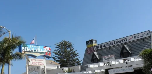
The Santa Claus Lane Beach Area in Carpinteria is a south facing beach area popular with surfers, boogie boarders and sunbathers. Get there from the 101 by taking the Padaro Lane exit towards Santa Claus Lane, then taking a left on Santa Claus Lane. You can park in a small dirt area (there's room for maybe 10 cars there) on the ocean side or find street parking, which is plentiful. This is not an "official" beach to my knowledge, as in city or county-run. Just a private beach. No restrooms to my knowledge. Oh yes, you'll have to cross the railroad tracks...so be careful! Down the street is Padaro Beach Village, where you can grab a bite to eat and do a little shopping.

On a separate note, you may be wondering why it is called Santa Claus Lane. Well the old-timers among you (including me) know that a gigantic roadside Santa used to reside here that now greets us off the 101 freeway in the Nyeland Acres section of Oxnard. Learn more about the history at this link.

Surfers, boogie boarders, body surfers and frolickers at the Santa Claus Lane area beach.

Surfers, boogie boarders, body surfers and frolickers at the Santa Claus Lane area beach.

Just down the street is the quaint Padaro Beach Village, where you can grab a coffee, breakfast, lunch, do a little shopping, etc. Very relaxing little area.

Just down the street is the quaint Padaro Beach Village, where you can grab a coffee, breakfast, lunch, do a little shopping, etc. Very relaxing little area.

Carpinteria State Beach is a mile long beach for swimming, surf fishing, tidepool exploring and camping. Dogs are allowed only at the picnic area. The park originally opened in February 1932. There are four campground areas with 216 family campsites and seven group campsites available. Seals and sea lions can be seen in the area December through May, as well as an occasional gray whale. Tidepools contain starfish, sea anemones, crabs, snails, octopi and sea urchins. Exit the 101 at Casitas Pass Road, go west to Carpinteria Avenue, make a right at the signal; then turn left on Palm.  The beach is at the end of Palm Avenue near 4th Street. Call 805.968.1033 or visit www.parks.ca.gov/?page_id=599.

Note: Campfires are only allowed in the campground in fire rings provided. No fires are allowed on the beach.

CarpStateBeach_sign.JPG

Tar Pits Park in Carpinteria provides hiking and biking trails and a few benches, but no other park amenities.  Access to the park is very remote and it is suggested that you enter from the Carpinteria State Beach campgrounds or beach area.  Here you will see tar oozing out of the hills...so watch where you step! The Carpinteria Tar Pits is one of five natural asphalt lake areas in the world! Visit carpinteria.ca.us/parks-and-recreation/park-system for more information. The Carpinteria Harbor Seal Rookery can be reached by following trails east of the park.

Beach view from Tar Pits Park in Carpinteria.

Beach view from Tar Pits Park in Carpinteria.

Carpinteria Bluffs Nature Preserve is 53 acres of open space situated overlooking the Pacific Ocean is a series of walkways, trails and open space for ocean views, whale watching and fresh air. There are restrooms and I believe parking is free. This is not a beach for hanging out on the sand. Visit www.carpinteria.ca.us/parks_rec/park_system.shtml for more information. Take the 101 Freeway to Ballard Avenue and turn towards the ocean.

Rincon Beach Park is near the Ventura/Santa Barbara County line just a few miles east of Carpinteria. Just take the Bates Avenue offramp off the 101 Freeway to the ocean and on the right you'll find plenty of free parking and easy beach access, with picnic tables and restrooms. Just steps to the south of Rincon Beach Park is Rincon Point, known as one of the best surfing spots in the world.

Great photo opps here at Rincon Beach Park :)

Great photo opps here at Rincon Beach Park :)

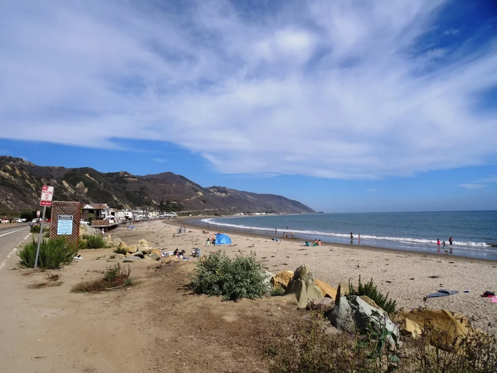
South of Rincon Beach Park is a newer (premiered September 2014) Class I bike path that takes you through the La Conchita Beach area to Mussel Shoals. La Conchita Beach is low key, with several access points from the La Conchita Bike Path area. You can park at Rincon Point and bike or walk to one of several access points from the path. You can also drive into La Conchita, find a parking spot and take the newer undercrossing that'll get you to the beach by walking under Highway 101.  No restrooms or other facilities to my knowledge at the beach. It’s several miles of beauty, directly adjacent to the 101.

La Conchita Beach

La Conchita Beach

Mussel Shoals is a small beach community in Ventura with around 50 homes. There are about a dozen public parking spots along Old Pacific Coast Highway, paralleling the 101 near the Cliff House Inn. No restrooms. If you go there, perhaps have lunch at the Cliff House Inn and take in the peaceful views, while also checking out man-made Rincon Island.

Mussel Shoals

Mussel Shoals

The beach between Mussel Shoals on the northwest and Seacliff on the southeast is referred to Oil Piers Beach. There used to be piers here until they were taken down in 1998. You get here either via the La Conchita Bike Path or by taking the Seacliff Exit (#78) from Highway 101, then take Pacific Coast Highway northbound to Mobil Pier Road, where you will drive under the 101 to find parking (and if there's no spots available, go back to PCH and you'll find some). No facilities to my knowledge at this beach.

Oil Piers Beach Ventura

Hobson Beach Park is located north of Faria Beach Park and the Rincon Parkway, at 5210 W. Pacific Coast Highway, Ventura. It is managed by the County of Ventura. Day use parking is free but limited. Restrooms available. Limited beach space. Camping and RV spaces are available on a first come, first served basis. CLICK HERE for more info or call 805.654.3951.

Rincon Parkway is located between Faria Beach Park and Hobson Beach Park on Highway 1 off the Ventura Freeway at 5275 Pacific Coast Highway, Ventura. 127 parallel parking spaces are available for RV use only; no camping. All RV's must be fully self-contained units as there are no hookups, utilities, etc. Minimal beach, mostly rocks. Next to a train track. But nonetheless fun to stop by from time to time. No day use parking. CLICK HERE for more info.

Faria Beach Park is located south of Hobson Beach Park is another popular RV/camping spot at 4350 W. Pacific Coast Highway, Ventura. Also managed by the County of Ventura with spots available first come, first served. There are restrooms. No dogs on beach but they are allowed in camping areas. CLICK HERE for more info or call 805.654.3951.

South of Faria Park and north of Solimar Beach is an area referred to as Mondos Beach. We recently rode bikes from the Ventura Pier past this area and saw plenty of families enjoying the sand and the water. There is parallel parking available on the old highway. I believe there are also some porta-johns available.

Mondos Beach area in Ventura, south of Faria, north of Solimar.

Mondos Beach area in Ventura, south of Faria, north of Solimar.

There's a strip of beach along Old Highway 1 between Mondos Beach and Solimar Beach that has parallel parking available, with large rocks separate the street from the beach. I don't know the name of this beach, but it is there, open to the public. There's not a specific street address but it is in the proximity of 3456 Pacific Coast Highway.

Solimar Beach is a strip of beach between Faria and Emma Wood known for surfing, swimming and fishing. Park along Old Highway 1. No facilities. There are about 60 homes along this beach.

Emma Wood State Beach** is popular for swimming, surfing and fishing.  The Ventura River estuary is at the mouth of the Ventura River at the southeast end of the park.  It attracts a variety of wildlife including raccoons, songbirds and great blue herons. Dolphins are occasionally seen just offshore. The park also features the crumbling ruins of a World War II coastal artillery site. Emma Wood offers family camping for self-contained vehicles only and group camping is available at Ventura River Group Camp. There are 90 campsites. There is a day use area in the park and beach access is available.  A bike path connects the park to Ventura and to the coast highway to the north. Parking is currently $10. Call 805.968.1033 or visit www.parks.ca.gov/?page_id=604. Directions at this link. Campfires not allowed on the beach.

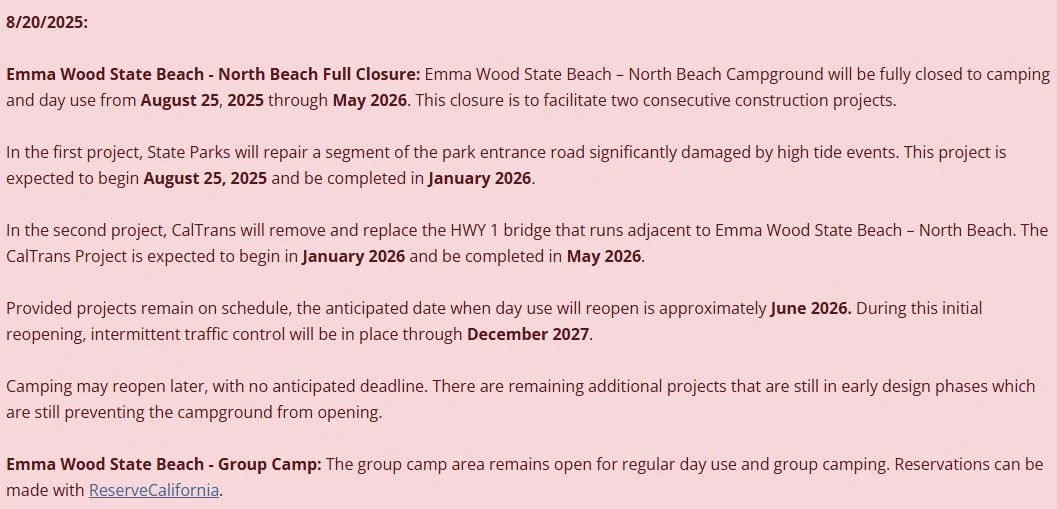
** Emma Wood State Beach - North Beach Campground will be closed for camping and day use from 8/25/25 through May 2026. See below.

We noticed a new sign at Emma Wood in the summer of 2015

We noticed a new sign at Emma Wood in the summer of 2015

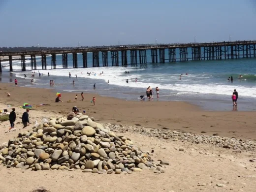
The Downtown Ventura Promenade beachfront area stretches from Surfers' Point and Promenade Park at Figueroa Street and Shoreline Drive on the north, down the Promenade bike/walk path to the Ventura Pier. This is a popular area with lots of surfers, a cool kids' playground area just north of the pier and plenty of beach with lots of interesting looking rocks. There are several restrooms in the area. Great place to go bike riding with the family. Plenty of parking in the area on the north end. On the south side by the pier you may need to pay for parking at the Crowne Plaza on Harbor Blvd east of California Street or at San Buenaventura State Beach further east.

SurfersPointSign.JPG
VenturaPromenadeRocks.JPG

San Buenaventura State Beach stretches from the Ventura Pier down south past the homes of the Ventura Keys to Marina Park. There are two miles of sandy beach, sand dunes, picnic sites, fairly large parking lot, and the Jolly Oyster. Bike paths connect to other nearby beaches. Wheel Fun Rentals is located near the Ventura Pier if you need a bike. Campfires not allowed at this beach. Main parking lot access point is at San Pedro St and Pierpont Blvd. Additional parking in a lot off of Harbor Blvd north of Sanjon Road. Visit www.parks.ca.gov/?page_id=600 for more information.

Marina Cove Beach is a very popular family spot located at Marina Park, with a newer, small playground area, lots of parking (though weekends can get pretty packed), restrooms and a nice family-friendly beach.. Walk from Marina Park south to Soter Point for picnic areas, mermaid statue and more.

SanBuenaventuraSB.JPG
Fun stone jetty to navigate at the beach adjacent to Marina Park in Ventura.

Fun stone jetty to navigate at the beach adjacent to Marina Park in Ventura.

Harbor Cove Beach is located at the west end of Spinnaker Drive near Ventura Harbor Village and across from the Channel Islands National Park Visitor Center. It is a "still water" beach protected by jetties that is considered one of the safest family friendly beaches in the area (and also referred to as "Mother's Beach"). Restrooms and showers are available and across the street, next to the Visitor Center, is the Harbor Cove Cafe. Paid parking is in effect on Friday through Sunday and major holidays from 10am to 8pm - cost is $1 per hour up to 4 hours. $10 for the day. Less than an hour is free. See venturaharbor.com/parking. Parking on Spinnaker Drive is free.

Harbor Cove Beach Lifeguard Station

Harbor Cove Beach Lifeguard Station

South Beach is located between Harbor Cove Beach and Surfers Knoll Beach off of Spinnaker Drive in Ventura.  This beach connects the two outer beaches and sits between two breakwaters and is good for relaxing, surfing, boogie boarding and more. Parking is available on Spinnaker Drive or park in the lot at the adjacent Harbor Cove Beach. As of July 2025, paid parking is in effect on Friday through Sunday and major holidays from 10am to 8pm - cost is $1 per hour up to 4 hours. $10 for the day. Less than an hour is free. See venturaharbor.com/parking. No restrooms available, but you can use the nearby Harbor Cove Beach restrooms.

South Beach in Ventura, between Harbor Cove Beach and Surfer’s Knoll Beach

Surfer's Knoll Beach is located in off of Spinnaker Drive in Ventura, across from Ventura Harbor Village. As its name implies, it is geared towards surfers, as well as others looking to relax and explore. Riptides are common here so be careful if you're a novice swimmer. There are restrooms and showers. But no lifeguards on hand. As of July 2025, paid parking is in effect on Friday through Sunday and major holidays from 10am to 8pm - cost is $1 per hour up to 4 hours. $10 for the day. Less than an hour is free. See venturaharbor.com/parking. Parking on Spinnaker Drive is free.

And there you have it! Let's take a break for now but as mentioned above, beaches stretching further down the coast through Oxnard, Channel Islands Harbor, Point Mugu and Malibu are covered in this separate post!

But wait! Here's a compilation of beaches in the City of Santa Barbara and surrounding areas!

Guide to Finding Family Friendly Bike Paths In and Around Ventura County

As a casual cyclist with young kids I usually steer clear of riding on busy streets, particularly those that don't have any type of bike lane on them. Thankfully there are nearly 80 miles of bikeways in Thousand Oaks, including 3 miles of bike paths, 20 miles of bike lanes and 54 miles of marked bike routes.  

Bike routes are shared with vehicles

Bike routes are shared with vehicles

Class I Bike Paths are separate from auto traffic and thus are great for family friendly cycling. Class II Bike Lanes are striped, painted and shared lanes adjacent to automobile lanes. Class III Bike Routes are marked by green signs that signify sharing with autos.

We also love taking our bikes to other places in and around Ventura County to enjoy other sights and surroundings. So how about if we highlight Class I Bike Paths throughout Ventura County, stretching from Thousand Oaks to Ventura.

Conejo Valley

The Conejo Creek Bike Path is a 1.2 mile path in the heart of Thousand Oaks that connects Gainsborough Road on the south to Conejo Creek Park and the Thousand Oaks Library. This is a nice, flat path, good for kids.

Another access point to the Conejo Creek Bike Path on La Granada Drive.

Another access point to the Conejo Creek Bike Path on La Granada Drive.

There is another Thousand Oaks bike path, the .5 mile Greenmeadow Drive connector bike path accessible on the west at Greenmeadow and Yellowstone, on the south side of Los Robles Greens. This is not a particularly interesting path but it does enable cyclists and walkers a path around the golf course to the Los Robles trailhead and Moorpark Road from Newbury Park. A bit hilly, too.

Entrance to Greenmeadow Avenue connector bike path in Thousand Oaks

Entrance to Greenmeadow Avenue connector bike path in Thousand Oaks

There is also the .8 mile bike path on the north side of The Oaks mall as well as the .5 mile Read Road Connector path accessible off of Olsen Road just east of the 23 freeway.

Sign at the Read Road connector path on Olsen Road east of 23 Freeway.

Sign at the Read Road connector path on Olsen Road east of 23 Freeway.

Medea Creek Natural Park has hiking, biking and fitness trails that stretch from Calle Rio Vista and Oaks Hills Drive in Oak Park on the north, then south past Medea Creek Lane and Conifer Street to a cul de sac entrance to the park at the west terminus of Tamarind Street. About a mile to mile and a half of paths, including paved and dirt paths.

Nicely paved path at Medea Creek Natural Park in Oak Park

Nicely paved path at Medea Creek Natural Park in Oak Park

Ventura

My personal favorite bike path in Ventura County is the Omer Rains Trail that runs the entire length of San Buenaventura State Beach.

Senator Omer Rains Ventura Oceanfront Bikeway Sign on Main Street next to Ventura Beach RV Resort

Senator Omer Rains Ventura Oceanfront Bikeway Sign on Main Street next to Ventura Beach RV Resort

We park the car at Marina Park in Ventura and ride a short distance north on Pierpont Blvd to the bike path entrance. This oceanfront path takes you past the Ventura Pier, through the Promenade area, adjacent to the Ventura County Fairgrounds, Emma Wood State Beach and beyond. Or you can get to the path from anywhere along the Ventura Promenade area.

Bike path along San Buenaventura State Beach.

Bike path along San Buenaventura State Beach.

Omer Rains Bike Path near Ventura Beach RV Resort on Main St.

Omer Rains Bike Path near Ventura Beach RV Resort on Main St.

Nice, newer paved section of Ventura beachfront bike path near Surfers Point.

Nice, newer paved section of Ventura beachfront bike path near Surfers Point.

The Ventura River Trail is a 6.3 mile asphalt pedestrian and bike path that follows the old Southern Pacific Railroad right-of-way from Main Street in Ventura to Foster Park inland towards Ojai. You can easily connect from the Omer Rains Trail to the Ventura River Trail up to the Ojai Valley Trail for quite a long, nearly automobile-free ride.

The Ventura Harbor Bike Path takes you 1.2 miles from Market St and Arundell Ave in midtown Ventura southwest through farmland to E. Harbor Boulevard and Schooner Drive, near Four Points by Sheraton.

Bike path from midtown Ventura to the Harbor is not the most exciting path but it is a convenient way to ride to Ventura Harbor, Marina Park and adjacent areas.

Bike path from midtown Ventura to the Harbor is not the most exciting path but it is a convenient way to ride to Ventura Harbor, Marina Park and adjacent areas.

The La Conchita Bike Path between Rincon Point at the Ventura/Santa Barbara County Line adjacent to Highway 101 past La Conchita to Mobil Pier Road in Ventura was completed in September 2014. This path has leapfrogged into my own personal favorite in Ventura County because of its spectacular beach views. This is about 4 miles of bike path in the Oil Piers Beach to Mussel Shoals to La Conchita Beach to Rincon Point beach areas.

Bike paths rarely get better than this stretch along the southbound 101 and the Pacific Ocean in Ventura.

Bike paths rarely get better than this stretch along the southbound 101 and the Pacific Ocean in Ventura.

There's another short stretch of bike path at the east end of Navigator Drive that goes west, then south, around the Ventura West Marina.

Entrance to short bike path adjacent to Ventura West Marina.

Entrance to short bike path adjacent to Ventura West Marina.

There is a two mile biking and hiking on the east side of the lake at the Lake Casitas Recreation Area, 11311 Santa Ana Road, Ventura. The path starts at picnic area #1 and follows the east shoreline of the lake for a four mile round trip ride. The path is paved in the recreational area and becomes a dirt road outside of that. More information at www.casitaswater.org/hiking-and-biking-trail.

Ojai

The Ojai Valley Trail is a 9 to 10 mile trail that parallels Highway 33 from Foster Park on the outskirts of west Ventura, to Soule Park in Ojai. It connects to the Ventura River Trail.

The Ojai Trail runs parallel to Ventura Ave/Ojai Ave.

The Ojai Trail runs parallel to Ventura Ave/Ojai Ave.

Simi Valley

The Arroyo Simi Bike Path is a two lane bike path in Simi Valley that runs from Madera Road, just south of Easy Street on the west, ending at Tapo Street on the east. Over seven miles.

Arroyo Simi Bike Path/Trail in Simi Valley.

Arroyo Simi Bike Path/Trail in Simi Valley.

Camarillo

We enjoy the newer, flat roughly 2 mile Calleguas Creek bike path from Pleasant Valley Fields up to the corner of Flynn and Upland Roads in Camarillo. Quick access from the Conejo Valley and a nice, relatively easy path good for all ages.

Look at how nice and flat this bike path adjacent to Calleguas Creek is!

Look at how nice and flat this bike path adjacent to Calleguas Creek is!

Other Areas

There's an online bike map available on the Ventura County Transportation Commission website at www.goventura.org where you can find other Class I, II and II bike paths around the county. Here are some of them.

The Santa Paula Bike Trail takes you roughly 3 miles on the east near W. Main St and Peck Rd to (roughly) Dike Road on the west

The Fillmore Bike Path runs from south of Highway 126 (Telegraph Road) up past Shiell Park.

In Moorpark there's a .5 mile path at Country Trail Park, around the neighborhood to the west, back to Mountain Trail Street.

There's a bike path that starts at the ocean side of'olołkoy Beach Park and takes you south all the way to Hollywood Beach and Channel Islands Harbor. Cross Harbor Boulevard and make your way into Channel Islands Harbor, where you can ride all the way to the south end of the harbor.

Bike path near Oxnard Beach Park and Channel Islands Harbor.

Bike path near Oxnard Beach Park and Channel Islands Harbor.

In Port Hueneme there's a bike path that starts off of Bard Rd, west of South J St, through Richard Bard Running Springs Park and takes you southwest all the way to Hueneme Beach.

If you're willing to venture a bit further away from Ventura County, the Marvin Braude Coastal Bike Path stretches over 20 miles, from Will Rogers State Park in Pacific Palisades to Torrance. Flat, adjacent to the ocean, and so many things to do along the way!

Marvin Braude Coastal Bike Path in Pacific Palisades

Marvin Braude Coastal Bike Path in Pacific Palisades

That should be enough to get you started! Looking for local cycling clubs? Find some of them at this link.