Cheeseboro Canyon vs Chesebro Road in Agoura Hills

CheeseboroApr18.jpg

Cheeseboro and Palo Comado Canyons cover over 4,000 acres in the northernmost section of the Santa Monica Mountains National Recreation Area, in the Simi Hills. The Chumash occupied these canyons for thousands of years, until ranchers came into the area in the 1800s. The natural landscape changed as a result to accommodate the needs of grazing cattle.

The National Park Service (NPS) acquired Cheeseboro Canyon in the early to mid 1980s and subsequently acquired Palo Comado Canyon (formerly known as the Jordan Ranch), in 1994.

Nearly every time we post an image from Cheeseboro Canyon to a social media site, someone points out, "it's not Cheeseboro, it's Chesebro."

Why is it called Cheeseboro when the road that gets you to the trailhead is called Chesebro?

According to one NPS Ranger I've spoken with, the original owner of the land in the late 1800s was Oscar Cheesebrough (yet a different spelling). The NPS adopted the U.S. Geological Survey spelling of Cheeseboro, while Caltrans adopted the name Chesebro.

Why the difference? That's not so clear. But what IS clear is that the actual canyon is called Cheeseboro Canyon and it is a beautiful place to hike and bike!

CheeseboroPic1.jpeg
ChesebroSign.jpg

The Carpinteria Tar Pits are One of Five Natural Asphalt Lake Areas in the World

The Carpinteria Tar Pits at Carpinteria State Beach are located in a designated area called Tar Pits Park. The Carpinteria Tar Pits are one of five natural asphalt lake areas in the world, 2nd in size to and older than the La Brea Tar Pits in Los Angeles.

These tar pits date back to the Pleistocene Age (Ice Epoch), which 2.6 million to 11,700 years ago. Evidence of imperial elephants, the giant sloth, bison, wolf, tusked mastodons and camels have been discovered in t

Read More

M*A*S*H Site at Malibu Creek State Park

Malibu Creek State Park is a wilderness wonderland, stretching over 8,000 acres in Calabasas, Agoura and Malibu. The park is a great place for hiking, biking, camping, picnicking and exploring. If you do plan to explore the park, be sure to check out the old M*A*S*H (or "MASH" television series set!

MalibuCreek_Mash1.jpg

Produced by 20th Century Fox, M*A*S*H was filmed from September 1972 to February 1983 over 11 seasons and 256 episodes on CBS. Exterior scenes were filmed at what is now Malibu Creek State Park. Over the years, the ambulance and other props left at the old site became less and less visible as the surrounding brush became overgrown.

In 2007, the set was restored with a shaded picnic area, military vehicles, ambulance, helipad and signpost. Check out the photos below, but, better yet, visit it in person! For more pictures and extensive information about the M*A*S*H set and Malibu Creek State Park, visit www.malibucreekstatepark.org.

MASH_sign.jpg

The M*A*S*H site is easily accessible from the main parking lot at Malibu Creek State Park, mostly on wide fire roads, with one significant hill, a bridge crossing and one somewhat rocky trail section. The path is about 2 1/2 miles each way, so it would be a good idea to bring drinks and snacks.

MalibuCreek_Mash2.JPG
MASH_3.JPG
MASH_4.JPG
MashSite4.JPG
MashSite6.JPG

Erbes Road in Thousand Oaks Named After Early Settlers in the Conejo Valley

Courtesy of Thousand Oaks Library calisphere.org/item/ark:/13030/c8w093ww

Courtesy of Thousand Oaks Library

calisphere.org/item/ark:/13030/c8w093ww

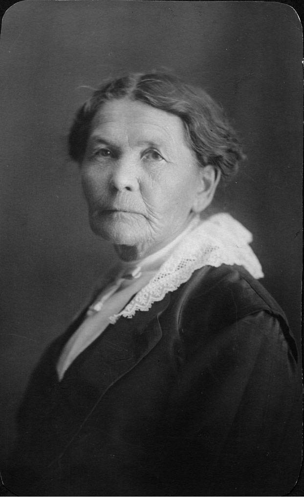
This is Elizabeth Opper Erbes. She is the mother of Ernest and Otto Erbes, who were early settlers in the Conejo Valley.

Otto (born in 1885, passed in 1959) owned a walnut orchard on what is now Erbes Road.

Estella Park on Erbes Road just south of Hillcrest is located on land donated to the city by Otto Erbes and his wife.

Erbes Road is a major north/south artery in the City of Thousand Oaks, stretching just over 5 miles, from Calle Zocolo, north of Olsen Road, on the north, to Thousand Oaks Boulevard on the south.

Olsen Road is also named after early Conejo Valley pioneer Nils Olsen. Olsen and four Norwegian compatriots purchased 650 acres of land from George Edwards in 1890.

Map From Westlake Master-Planned Community Brochure from 1968

In 1968, the American-Hawaiian Land Company, a division of American-Hawaiian Steamship Company, was developing the Westlake master-planned community, "the new city in the country."

At the time, 2,500 people lived in Westlake. The Ventura County sections of Westlake were annexed into the City of Thousand Oaks in 1968 and 1972. The Los Angeles County section of Westlake was incorporated as the City of Westlake Village in 1981. Some notable items from this 1968 map from a Westlake brochure:

1. "El Conejo Blvd." was later changed to Thousand Oaks Blvd.

2. Westlake Plaza did not exist at the time, though you can see "Future Town Center."

3. What is now Westlake Village Inn, Mediterraneo and Stonehaus back then was the Westlake Motor Hotel, Westlake Inn restaurant and Chauncey's Coffee House.

4. Last, but not least, there was no Costco in the original planned community map.

More information about the City of Westlake Village boundary lines at THIS LINK.

Evolution of the Conejo Grade in Ventura County Over the Last 100 Years

Horseshoe shaped section of the Conejo Grade in the 1920s.

Horseshoe shaped section of the Conejo Grade in the 1920s.

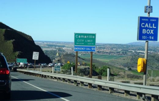
The Conejo Grade is the section of Highway 101 that connects the Conejo Valley with Camarillo. It is a four mile stretch of freeway with a significant 7% grade.

Going down the Conejo Grade from Newbury Park to Camarillo today.

Going down the Conejo Grade from Newbury Park to Camarillo today.

At 3:30 p.m. on the afternoon of May 1, 1937, a newly upgraded and realigned Conejo Grade premiered after a day of celebration commencing at the ranch of Adolfo Camarillo. Camarillo, the namesake of what in 1964 became the City of Camarillo, donated the right of way to enable the grade to be realigned. Actor Leo Carrillo entertained guests at Camarillo's ranch at the bottom of the grade.

Grand opening of the newly realigned Conejo Grade on May 1, 1937.

Grand opening of the newly realigned Conejo Grade on May 1, 1937.

The old Conejo Grade was constructed by the California Highway Commission in 1914-1915. The previous route had 49 twists and turns, making it somewhat hazardous to drive (albeit somewhat less steep than the current grade). The newly aligned Conejo Grade cut the number of curves by 75%.

Another view of the Conejo Grade before it was realigned in 1937.

Another view of the Conejo Grade before it was realigned in 1937.

The new 1937 Conejo Grade cost a total of $570,000, which is less than the average cost of a house in the Conejo Valley today! Over a year and a half, the project employed about 100 workers who put in over 272,000 hours, excavating over 800,000 cubic yards of mostly hard rock. Talk about rock stars!

In the 1950s and 1960s, Caltrans further widened and improved Highway 101 over the Conejo Grade.

In the 1950s and 1960s, Caltrans further widened and improved Highway 101 over the Conejo Grade.

Several decades later, as Ventura County grew and the cities of Camarillo and Thousand Oaks incorporated in 1964, Caltrans continued to widen and improve the highway to what it is today.

ConejoGrade2014_2.jpg

Source for historical information: "California Highways and Public Works" (May 1937) - official journal of the State of California Division of Highways, Department of Public Works.

Special thanks to the Pleasant Valley Historical Society for providing historic photos.

Then and Now: The Dairy Farm at Camarillo State Hospital

In 1932, the State of California purchased 1,760 acres of the Lewis Ranch and built the Camarillo State Mental Hospital, which operated from 1936 to 1997 and at one point treated as many as 7,000 patients in the mid 1950s.

Located on the parcel was a dairy farm that produced crops and housed livestock that fed the hospital community. The farm was disbanded in the 1960s and has been left in a state of disrepair, falling prey over the decades to vandals and coined "Scary Dairy."

Here are some "then and now" photos of the most prominent elements of the dairy farm.

The hay barn at Camarillo State Hospital in the 1940s (CSUCI John Spoor Broome Library historic photo collection)

The hay barn at Camarillo State Hospital in the 1940s (CSUCI John Spoor Broome Library historic photo collection)

The hay barn today.

The hay barn today.

The dairy at Camarillo State Hospital in the mid-1950s. (CSUCI John Spoor Broome Library historic photo collection)

The dairy at Camarillo State Hospital in the mid-1950s. (CSUCI John Spoor Broome Library historic photo collection)

The dairy building today, fenced off, covered with graffiti. 

The dairy building today, fenced off, covered with graffiti. 

Inside the hay barn - undated photo. (CSUCI John Spoor Broome Library historic photo collection)

Inside the hay barn - undated photo. (CSUCI John Spoor Broome Library historic photo collection)

Inside of hay barn - more recently.

Inside of hay barn - more recently.