Aviation Museum of Santa Paula

aviationmuseumsantapaula.gif

The Aviation Museum of Santa Paula is open the first Sunday of each month, with a "Chain of Hangars" from 10 a.m. to 2 p.m.  Closed if there is rain. FREE (but donations are appreciated).

Hangar Number One is the first in the museum's chain of hangars. It tells the story of the founding of Santa Paula Airport in 1930. Each of the privately owned hangars houses a variety of vintage aircraft and privately owned collections of memorabilia, from antique radios to race cars. Several other aircraft owners put their antique aircraft on display and many vintage aircraft also fly in each month.

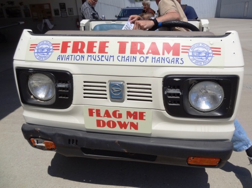
A museum tram is available to save you some steps between hangars. The Experimental Aircraft Association Chapter 723 offers free airplane rides to kids ages 8-17. The Museum's Gift Hangar, located inside CP Aviation, offers a variety of toys and apparel for airplane buffs of all ages.

More information at www.aviationmuseumofsantapaula.org or call 805.525.1109. The Aviation Museum is located near the corner of Santa Maria Street and 8th Street in Santa Paula. More info at this link.

SPAviationMuseum.JPG
AviationMuseumTram.JPG

Triunfo Canyon Trail in Westlake Village

TriunfoCanyon_sign.JPG

If you are looking for peaceful trails and outstanding panoramic views of the Conejo Valley from Thousand Oaks to Westlake Village, Hidden Valley and beyond, take a look at the Triunfo Canyon Trail, accessible from Triunfo Community Park, Triunfo Canyon Road at Tamarack Street in Westlake Village.

TriunfoCanyon1.JPG

The trailhead is on the northwest end of the park, near the tennis courts. It is a beautiful, winding, single track canyon trail for most of the first mile or so, then links up to the main Los Robles Trail and utility road, which is much wider.

Views of the Westlake Lake area from the Triunfo Canyon Trail.

Views of the Westlake Lake area from the Triunfo Canyon Trail.

You'll discover some steps to a bench at the top offering a birds eye view of the surrounding areas. It really is spectacular up there and the images here don't come close to doing the view justice.

Bench at the top of the hill allows you to catch your breath and take in the sights.

Bench at the top of the hill allows you to catch your breath and take in the sights.

From the bench, either turn around and go back down the hill or continue your way on if you'd like to the Los Robles Trail, above the Los Padres Trail.

One thing I'll say about these trails is that they seem particularly rocky, so wear decent shoes, as you don't want to twist your ankle. A bit of a climb to get up there; about 1,000 feet.

Learn more about the trail on the Conejo Open Space Foundation website at cosf.org/trails/los-robles/los-robles-moderate-hike-triunfo-park-to-east-los-robles-trail.

TriunfoCanyon6.JPG

Janss Marketplace in Thousand Oaks

Janss Marketplace in Thousand Oaks

Janss Marketplace at 275 North Moorpark Road in Thousand Oaks (corner of Moorpark Road and Hillcrest) is an open air mall that has a large outdoor eating area, interactive water fountain, monthly Kids Fun Zone and outdoor kids play area.

Retailers and other businesses at Janss Marketplace include Gold's Gym, Ulta Beauty, Old Navy, Nordstrom Rack, DSW Shoe Warehouse, Aldi, Five Below, Petco and others.

Eateries include Buca di Beppo, Panera Bread, Karma Indian Cuisine, Crazy King Kong Sushi, Lucky's Dog House, Sunset Terrace Restaurant, Greco's New York Pizzeria, Cold Stone Creamery, Sharky's, Matcha Tea and Boba, Janchi Korean BBQ, California Fish Grill, Eureka Brewing Company, Starbucks, Wingstop, O’t Bistro and Pieology.

And for entertainment, there’s Regal Cinemas, Defy Extreme Sports, Dave & Buster’s and The Mighty Axe.

There are plans for a 5-story, 216 room Homewood Suites & Home2 Suites hotel on the property that includes 13,000 sq ft of retail space. Pending zoning approvals for a 75 foot height, construction is anticipated to begin in the spring of 2024, with a target opening date of winter 2025.

For more information visit www.janssmarketplace.net or call 805.495.4662.

In 2009 the Janss Marketplace added a NEOS Wall, a fun interactive game right outside the Golds Gym.  This game is free. 

Some former occupants of Janss Marketplace: Toys R Us (summer 2018) Wachovia Banking Center (closed April 2011), Akio’s Sushi (Oct 2012; now Crazy King Kong Sushi), Sizzler/Fuddruckers/Hooters (currently vacant), TGI Fridays (2012)/DISH (Nov 2013) (now Janchi), Aaron Brothers (2018), Tuesday Morning (June 2012), Radio Shack, Marshalls, Mervyn’s, Mann 9 Theatres/Regency Theatres (now Regal Cinemas), Burger King/Salad Gourmet (2016)/Poke Tiki (Apr 2019). Subway (August 2019)., The Dudes' Brewing Company (March 2020). Burlington Coat Factory (July 2021) and Naru Bento (June 2022).

Janss Marketplace History

  • Originated in the 1960s as the Conejo Village Shopping Center. Also referred to as “The Mall.”

  • Changed its name to Janss Mall in August 1978. This came four months after The Oaks mall opened in Thousand Oaks. A key reason for the name change was to distinguish the “old” mall from the new mall.

  • Changed its name to Janss Marketplace in 1995, when it added the Mann 9 Theatres, Mervyns, Linens N’ Things, Best Products and other businesses.

Janss Mall sign in Thousand Oaks News Chronicle - November 12, 1978

Thousand Oaks Community Gallery

Thousand Oaks Community Gallery.gif

The Thousand Oaks Community Gallery at 2331-A Borchard Road, Newbury Park opened in February 1991 and was the realization of the combined efforts of the City Of Thousand Oaks, area art organizations and dedicated art patrons. The 3,000 sq ft gallery hosts visual arts exhibitions, workshops, artist presentations and special events, and is enhanced with a multi-purpose area that includes kitchen facilities and is available for group tours and special events. Original art is available for purchase for personal or corporate collections. The gallery showcases outstanding work of acclaimed, professional and emerging artists who present an exceptional array of original imagery, artistic techniques and visual styles.

Gallery operations are under the direction of City staff and a steering committee, consisting of regional visual arts association representatives and dedicated arts leaders. Operating costs are covered by a modest user fee paid by exhibiting artists and an active volunteer corps serve as staff. Gallery hours vary by exhibit.

More information at www.tolibrary.org/services/get-involved/thousand-oaks-community-art-gallery

Bark Park Trail in Calabasas

BarkPark_sign.JPG

The Calabasas "Bark Park" is located at 4232 Las Virgenes Road. To get there from the 101, take Las Virgenes Road south just under a mile. The entrance is on the left (east). If you're going fast, it is easy to miss it. It's a nice, local dog park open sunrise to 9pm with plenty of space for the doggies as well as a separate gated kids' play area and plenty of parking.

BarkPark_trailhead.JPG

On the north side of the park is the trailhead to the Bark Park Trail, a 1.2 mile climb that links you up with the New Millenium Loop Trail. Round trip you're talking about a 2 1/2 mile hike.

BarkPark_trail.JPG

It is a nicely maintained trail with a steady, uphill climb. I would call it a moderate climb for the most part. A good walk to take the kids on. But it can get a bit hot up here, so bring water and sunscreen on summer days.

Trail sign at the junction of Bark Park Trail and New Millennium Loop Trail.

Trail sign at the junction of Bark Park Trail and New Millennium Loop Trail.

As you can see from the sign, there's a lot more exploring you can do on these nicely maintained trails in Calabasas.

A view of the Bark Park from the trail above.

A view of the Bark Park from the trail above.

Wildwood Park in Thousand Oaks

The main entrance into the 1,765 acre Wildwood Park is at the corner of Avenida de los Arboles and Big Sky Drive in Thousand Oaks. The Chumash Indians lived in Wildwood Park for nearly 8,000 years, until the early 19th century, when the Spanish colonized California. Eventually the park became owned by the Janss Corporation, which sold it to the Conejo Recreation and Park District in 1967.

Main trailhead accessible from the parking lot at Ave de los Arboles and Big Sky.

Main trailhead accessible from the parking lot at Ave de los Arboles and Big Sky.

Wildwood Park is an extremely popular hiking and cycling spot and CRPD frequently hosts nature hikes there. The park has 14 trails covering 17 miles, including two year-round waterfalls, Paradise Falls and Little Falls.  Wildwood is known for its spring wildflower displays from January to June.

The park hosted a number of movie/TV productions in the 1930s to the 1960s, including Spartacus, Wuthering Heights, Wagon Train, The Rifleman and Gunsmoke.

Call the CRPD at 805.495.2163 for more information about the park. But for lots of detailed information about Wildwood Park, including trail maps and pictures, visit the Conejo Open Space Foundation website at cosf.org/trails/wildwood.

As far as facilities in the park, there are drinking fountains at the main parking lot as well as at the Teepee, at Paradise Falls and the two restroom areas in the park. One of the restrooms are located at Meadows Center, a small building located across the bridge that is adjacent to the short trail to Little Cave. CRPD often hosts short hikes from the main parking lot to Meadows Center for fun, games and s'mores.

Bridge over creek that connects Wildwood Canyon Trail to Meadows Center, which has restrooms and a drinking fountain.

Bridge over creek that connects Wildwood Canyon Trail to Meadows Center, which has restrooms and a drinking fountain.

The other restrooms are at the bottom of Wildwood Canyon. You can get there by taking the Tepee Trail roughly 1/2 mile to the bottom of the canyon, or alternatively from Paradise Falls about 1/4 mile down the Wildwood Canyon Trail. The Arroyo Conejo Creek runs down from Paradise Falls to here and is fun to explore (keeping in mind still that this is partially urban runoff and thus you don't want to play around in it too much).

Additional restrooms at the bottom of Wildwood Canyon.

Additional restrooms at the bottom of Wildwood Canyon.

Sign at Paradise Falls indicating this particular water is partially urban runoff and best not to swim in.

Sign at Paradise Falls indicating this particular water is partially urban runoff and best not to swim in.

Wildwood2.JPG
Wildwood4_sign.JPG
Tepee Wildwood.JPG

Leo Carrillo State Park in Malibu

LeoCarilloSign.JPG

Leo Carrillo State Park consists of 1.5 miles of beach for swimming, surfing, windsurfing, surf fishing and beachcombing, as well as tide pools, coastal caves and reefs. Giant sycamores shade the main campgrounds.

Among the many great features of Leo Carrillo, the most engaging activity for me and the kids is the tide pools. They are exposed twice daily at low tide and provide hours of engagement with sea stars, sea anemones, mussels, sea slugs and more.

Nature walks and campfire programs are offered and a small visitor center has interpretive displays.

Trails include Yellow Hill Fire Trail for panoramic views of the beach and the Channel Islands, and the steeper Nicholas Flat Trail, which brings you to a pond.

There are 135 family campsites at Leo Carrillo with restrooms and token-operated showers. Visit ReserveCalifornia.com and search for “Leo Carrillo SP” to make reservations.

The park was named after Leo Carrillo (1880-1961), actor, preservationist and conservationist. Leo Carrillo served on the California Beach and Parks commission for 18 years and was instrumental in the state's acquisition of the Hearst property at San Simeon. Leo's greatest fame came from his portrayal of Pancho, the sidekick to Duncan Renaldo's Cisco Kid, an early 1950's TV series.

Leo Carrillo State Park is located at 35000 W. Pacific Coast Highway in Malibu. The park office phone is 310.457.8143. Visit www.parks.ca.gov/?page_id=616 for more information.

Parking is currently $12 in the parking lot for the day (or $3 per hour)...but free on PCH if you can find a spot. There are plenty of parking spots available in the lot. After you park, you can walk in a tunnel underneath PCH to get to the beach.

The muraled tunnel that takes you underneath PCH to Leo Carrillo Beach.

The muraled tunnel that takes you underneath PCH to Leo Carrillo Beach.

Dogs on a leash are allowed in the Park's day use areas, campground and north beach (north of lifeguard tower 3). Dogs are not allowed on backcountry trails or south beach (south of lifeguard tower 3).

DIRECTIONS

The most direct way of getting to Leo Carrillo from the Conejo Valley is via Westlake Boulevard (CA-23) (aka Decker Canyon) south, which for some is a fun 14 mile drive, but for others, not so much. It is a bit winding, hilly, steep at many junctures. I take this route during daytime hours but coming home I'm not too keen on it. After getting to PCH, turn right and drive 2 1/2 miles to get to Leo Carrillo.

Another more popular, though less direct route is via Kanan Road. Either take Kanan Road straight down to PCH, turn right (west) on PCH about 9 miles to Leo Carrillo, or take Kanan to Encinal Canyon, which is about a 3 mile drive on PCH to Leo Carrillo.

Lastly, if you are in Newbury Park, you can take Potrero Road west to Las Posas down to PCH. In about 11 miles you will reach Leo Carrillo.

Malibu Lagoon State Beach

Malibu Lagoon State Beach is where Malibu Creek meets the Pacific Ocean. To get there, park either at the state lot (corner of Pacific Coast Highway and Cross Creek Road) for a fee, along Pacific Coast Highway or across the street in spots available near Malibu Country Mart and the Malibu Civic Center.

The lagoon is serene, with a sandbar of pelicans enjoying their summer day. This beach extends southeast to Surfrider Beach and the Malibu Pier, which is just a short walk away. While you're there try to check out the Adamson House and Malibu Lagoon Museum.

More information at www.parks.ca.gov/?page_id=835. Dogs are not allowed at Malibu Lagoon State Beach and trails.

MalibuLagoon1.5.JPG
MalibuLagoon2.JPG
MalibuLagoon3.JPG
MalibuLagoon4.JPG

Paradise Cove Beach in Malibu

If you’re looking for a great spot to dine at the beach, the Paradise Cove Beach Cafe in Malibu is a great choice. Located at 28128 E. Pacific Coast Highway in Malibu, it’s about a 30 minute drive from Thousand Oaks via Kanan Road. Learn more at www.paradisecovemalibu.com.

The public is welcome to access Paradise Cove Beach, including the dry stretch of beach around the pier (49 feet in width) as well as use the area of the beach below the mean high tide line for the entire shoreline length of the Paradise Cove property. You can either park on PCH and walk to the beach, or you can pay to park in the Cafe parking lot. But yes, it is expensive. It is much less expensive to park and dine at the cafe, which covers you for up to 4 hours of parking.

While some would argue that the food isn’t great and prices (including parking) is too high, my opinion is….it’s all about location, location, location.

About half a mile south on PCH is the access point to Escondido Falls, a four mile round trip hike to the tallest waterfall in the Santa Monica Mountains (over 150 feet). A fun excursion - park on PCH and do the Escondido Falls hike. Then walk down the street to the Paradise Cove Cafe. Of course don’t leave valuables in your car.

Parking fees as of June 2023.

Lizard Rock Trail From Lizard Rock to Wildwood Canyon at Wildwood Park Thousand Oaks

This is one in a series of posts about trails in the 1,765 acre Wildwood Park in Thousand Oaks.

Lizard Rock at Wildwood Park

Lizard Rock at Wildwood Park

Lizard Rock is a popular 2 mile round trip destination for hikers from the main parking area in Wildwood Park, mostly on the Mesa Trail. It is a moderate hike with an elevation gain of about 300 feet to its peak at 931 feet.

Sign just south of Lizard Rock indication direction of Lizard Rock Trail towards Wildwood Canyon

Sign just south of Lizard Rock indication direction of Lizard Rock Trail towards Wildwood Canyon

After reaching Lizard Rock, some folks (hikers and bikers) venture further south on the Lizard Rock Trail about .8 mile of downhill that takes you past the City of Thousand Oaks Hill Canyon Water Treatment Facility to the Wildwood Canyon area, a drop of about 600 feet in elevation.

View of Hill Canyon Waste Treatment Plan from near Lizard Rock

View of Hill Canyon Waste Treatment Plan from near Lizard Rock

The descent down the Lizard Rock Trail provides nice views into the Santa Rosa Valley as it zigs and zags towards the bottom. You can see Hill Canyon from Lizard Rock but as you move down the hill you will get a much clearer view of this high tech facility that converts wastewater into a reusable water source. You will indeed catch some whiffs of smells that aren't particularly pleasing down there but having been down there myself a number of times, it ain't that bad.

The descent down Lizard Rock Trail

The descent down Lizard Rock Trail

Before you reach the bottom, there are several overlook benches available to take a break as you look towards the Arroyo Conejo, Santa Rosa Valley and beyond.

The first of two overlook benches facing west on the Lizard Rock Trail

The first of two overlook benches facing west on the Lizard Rock Trail

A view of the same bench looking back up (north) towards Lizard Rock (yes, that's the lizard head poking out of the hill on the right).

A view of the same bench looking back up (north) towards Lizard Rock (yes, that's the lizard head poking out of the hill on the right).

And here's the 2nd bench, further down the Lizard Rock Trail. Is that actual green I see up ahead in late September!? Yes it is. Must be drought-tolerant native shrubs!

And here's the 2nd bench, further down the Lizard Rock Trail. Is that actual green I see up ahead in late September!? Yes it is. Must be drought-tolerant native shrubs!

Hill Canyon comes into closer view

Hill Canyon comes into closer view

As you can see, the Lizard Rock Trail starts heading back east as it traverses the Hill Canyon Treatment Plant. Amazing facility. I wouldn't want to go swimming in the green liquid however.

As you can see, the Lizard Rock Trail starts heading back east as it traverses the Hill Canyon Treatment Plant. Amazing facility. I wouldn't want to go swimming in the green liquid however.

At the very bottom of the trail, after you have completely passed the water treatment plant, you see this sign that indicates you are on your way towards Lower Wildwood Canyon.

At the very bottom of the trail, after you have completely passed the water treatment plant, you see this sign that indicates you are on your way towards Lower Wildwood Canyon.

So you've reached the bottom of Wildwood Canyon and other than heading back up that steep Lizard Rock Trail to where you just came from, you can take the more interesting loop route following the Wildwood Canyon Trail to Wildwood Canyon. There are restrooms, drinking fountain and picnic tables in there.

From Wildwood Canyon, either continue onward up the Wildwood Canyon Trail about a third of a mile to Paradise Falls, or the Tepee Trail (yes, this is what it is called on the map), which largely parallels the Wildwood Canyon Trail, up towards, yes, the Tee Pee. Then follow the signs back

There is a great map that covers this Lizard Rock to Paradise Falls to Two Springs (formerly Indian Creek) Trail loop, about 4 1/2 miles in total, on the Conejo Open Space Foundation website at www.cosf.org/website/html/lizard-waterfall-creek.html.

Since we're down at the bottom of the canyon, you will see a sign for "Skunk Hollow." This is a tree-lined area adjacent to the creek with a picnic bench. Kind of nice little area, just around the corner from the waste treatment plant, albeit not within view of the plant. 

And in that area, you will see a sign indicating Eagle Point Trail. Eagle Point Trail is a hilly little 1/3 of a mile alternate route that gets you into Wildwood Canyon. The first section has dozens of steps. The remainder has a few steep sections. Just a small side attraction to check out. 

Eagle Point Trail Wildwood Park

El Rincon, El Cerro and Las Brisas Trails in Dos Vientos Section of Newbury Park

In the heart of Dos Vientos (Spanish for Two Winds), there are three trails that are accessible from multiple spots by walkers, hikers, runners and bikers. These are the El Rincon, El Cerro and Las Brisas trails. These trails are all nicely maintained, single track and provide great views of the surrounding areas. Other trails surrounding Dos Vientos include the Vista Del Mar Trail, Sierra Vista Trail, Sumac Trail (kind of parallels Sierra Vista Trail), El Encanto Trail and Powerline (Edison Road) Trail, as well as the Potrero Ridge Trail.

ElRincon_trailhead.JPG

Access to the El Rincon Trail is near the corner of Via Rincon and Rancho Dos Vientos. The trail is about 4/10ths of a mile and connects with the El Cerro and Las Brisas trails.

ElRinconTrail1.JPG
ElRinconTrail2.JPG

Access to El Cerro and Las Brisas trails is at the juncture of Via Las Brisas and Calle Del Prado and several other points. Visit https://cosf.org/files/maps/dos_vientos_trail_map.pdf for a trail map on the Conejo Open Space Foundation website.

ElCerroLasBrisas_sign.JPG

Conejo Valley Art Museum

Founded in 1978, the Conejo Valley Art Museum is a non-profit organization that supports local arts in the Conejo Valley. Over the years it has resided in several locations in Thousand Oaks while the Museum's Board of Trustees work towards obtaining additional funds to acquire a permanent home.

Since 2011, Janss Marketplace was its home from 2011 to the 2024 time frame. It is currently (as of May 2025) looking for a new home.

For more information about CVAM, visit www.conejovalleyartmuseum.org.

Brief tour of space at the Janss Marketplace as of mid-July 2012 is shown below.

Point Dume State Beach

On November 24, 1793, English explorer George Vancouver named the rocky promontory Point Dume after his friend, Father Francisco Dumetz. Point Dume is the western terminus of Santa Monica Bay and was named California Registered Historical Landmark No. 965.

PointDumeBeach.JPG

View in the spring of 2023

Point Dume State Beach is a 63 acre promontory that juts out into the Pacific and features headlands, cliffs, rocky coves and vast beach access for swimming, surfing and scuba diving.

To get to Point Dume State Beach, take Westward Beach Road southeast from PCH near Zuma Beach's south side to the paid parking area, or park on Westward Beach Road, which parallels Westward Beach.

To the southeast of Westward Beach is a small 300 foot or so beachfront area called Pirate's Cove Beach (which due to its seclusion was once used as a nude beach).

Pirate's Cove beach seen from the top of the promontory. You can climb down there and when the tide is moderate to low, walk around to it.

Pirate's Cove beach seen from the top of the promontory. You can climb down there and when the tide is moderate to low, walk around to it.

The 34-acre Point Dume Natural Preserve also begins from the cul-de-sac. A gradual ascending trail leads to an ancient coastal bluff sand dune with spectacular views...we've seen whales, seals and dolphins over here. A stairway from the east side of the bluff-top preserve allows access to a more isolated beach and tidepools (look but don't touch). You'll have fun exploring up here.

In the spring of 2023

This is a snippet of the pilot episode, "The Lady in the Bottle," of I Dream of Jeannie that originally aired September 18, 1965. If you skip to 1:39 in this clip, you will see the prominent rock formations on the east side of the Point Dume promontory. Below is a more recent shot of that area.

This is where Captain Anthony Nelson (Larry Hagman) made a giant S.O.S. in the sand with sticks and other items, including an old bottle that moved itself. He picks it up, dusts it off, and out pops Barbara Eden. Lucky guy!

This is where Captain Anthony Nelson (Larry Hagman) made a giant S.O.S. in the sand with sticks and other items, including an old bottle that moved itself. He picks it up, dusts it off, and out pops Barbara Eden. Lucky guy!

Location/Directions: Take Kanan south to PCH and turn right. Westward Beach Road is over the rise, at the foot of the hill. Park free on WBR or pay a fee at Westward Beach lot. No restrooms at the Preserve but some can be found on WBR. Call 310.457.8143 or visit www.parks.ca.gov/?page_id=623 for more information. Also see beaches.lacounty.gov/point-dume-beach.

Dogs are not allowed on trails in the Point Dume Natural Preserve or on the beach.

Westward Beach

Westward Beach

Springtime at the Point Dume Natural Preserve

Springtime at the Point Dume Natural Preserve