Scenes in Pt Mugu State Park After Re-Opening Last Friday, May 24th

The Springs Fire started the morning of May 2nd along the 101 freeway on the Conejo Grade and burned over 28,000 acres through portions of Camarillo, Newbury Park and the Santa Monica Mountains Recreational Aea until it was fully contained the following week.

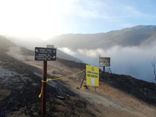
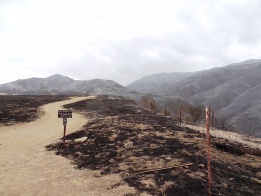
Portions of Rancho Sierra Vista/Satwiwa re-opened on Tuesday, May 14th. Remaining trails in Pt Mugu State Park were opened by the National Park Service last Friday, May 24th, giving the public access to Sycamore Canyon, Boney Mountain Wilderness and other marked trails.

Local residents Dianne Avery of Dianne Avery Photography and her photo model Renee Simon captured some of the moment yesterday in Rancho Sierra Vista/Satwiwa.

Photo by Dianne Avery; Picture is Renee Simon. Both are local Newbury Park residents who frequently explore the trails in Rancho Sierra Vista/Satwiwa.

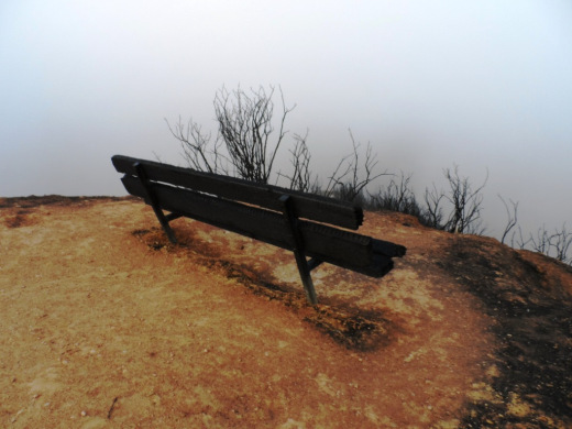
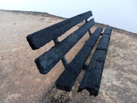
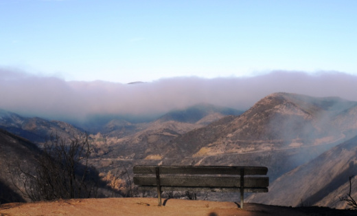
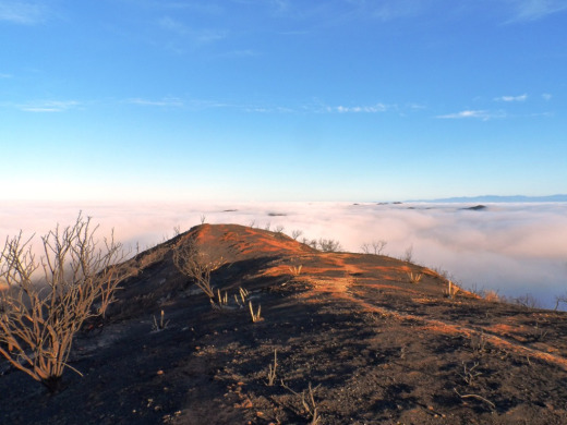
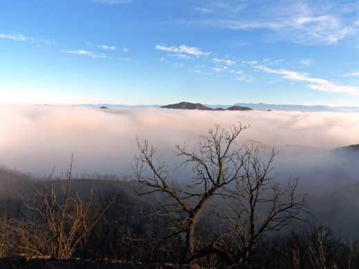
And below are a few other shots taken while exploring the area.


Additional photos available at www.facebook.com/ConejoValleyGuide

Fire on the Conejo Grade morning of May 2nd

Burned areas in Rancho Sierra Vista/Satwiwa and Dos Vientos on May 5th

Rancho Sierra Vista/Satwiwa on May 14th

Pt Mugu State Park up to Danielson Monument on May 24th

Sycamore Canyon to Danielson Multi-Use Area in Pt Mugu State Park on May 25th

Remaining Trails in Pt Mugu State Park, Sycamore Canyon to Re-Open Tomorrow

Today the National Park Service announced that all major trails in the Santa Monica Mountains National Recreation Area burned areas in Pt Mugu State Park will re-open tomorrow, Friday, May 24th, including Sycamore Canyon Fire Road, the trail to the Danielson Monument, Sycamore Canyon and La Jolla campgrounds, etc., as long as the trails are authorized, marked and mapped. Expect some trail closures for repair intermittently. Here are some before and after shots of a few scenes in Rancho Sierra Vista/Satwiwa in Pt Mugu State Park.

View looking down Sycamore Canyon on May 5, 2013.View from top of Sycamore Canyon on February 10, 2013.

Another post-Springs fire view down Sycamore Canyon.Another view looking down Sycamore Canyon on 2/2/13.Boney Mountain Trail sign in Rancho Sierra Vista post-Springs fire 5/5/13.Boney Mountain Trail sign in Rancho Sierra Vista/Satwiwa on 2/10/13.Bench at Sycamore Canyon Overlook on 5/14/13.Bench at Sycamore Canyon Overlook on 2/10/13.

Portions of Rancho Sierra Vista/Satwiwa in Newbury Park Opened This Morning

As announced yesterday, the National Park Service has opened certain sections of Rancho Sierra Vista/Satwiwa in Newbury Park this morning. Due to the extensive fire damage to roughly 70% of the 1,170 acres, most areas will not be initially be accessible. The public will not have access into Sycamore Canyon, the "Waterfall," Danielson Monument and other areas until the National Park Service deems these areas suitable and safe. I explored the area early this morning and indeed, under the cloud cover, there was much devastation to be seen...though no structural damage that I could see other than this bench overlooking Upper Sycamore Canyon.

This bench overlooking Upper Sycamore Canyon put up a good fight.Danielson Road trail to the Waterfall, Monument and Boney Mountain Wilderness is currently closed, though Hidden Valley Overlook to the left is accessible.A bit of cloud cover in Newbury Park this morning after two blistering hot days.Scenes from the Hidden Valley Overlook trail amid charred hills.

More photos on the CVG Facebook page at THIS LINK.

National Park Service to Re-Open Some Santa Monica Mountains Trails on May 14th

Now that the 24,000-acre Springs Fire is officially controlled, the National Park Service has announced it will re-open some trails on the western side of the Santa Monica Mountains on Tuesday morning, May 14th, with restrictions.  

Before and after Spring fire view from bench at Upper Sycamore Canyon Overlook at the boundary of California State Parks and National Park Service land in Pt Mugu State Park (photo on right courtesy of National Park Service).

Rancho Sierra Vista in Newbury Park will partially re-open, but some trails will remain off-limits and the park will close from sunset to sunrise. Due to ongoing safety concerns and trail damage, visitors will not be able to travel into Sycamore Canyon, but will be able to reach the overlook at the boundary with Point Mugu State Park.  

The Sandstone Peak and Mishe Mokwa trailheads will also re-open, as will the Backbone Trail east of the Point Mugu State Park boundary. California State Parks land sustained severe fire damage and all backcountry trails in the area remain closed. 

According to the NPS map, the public will not initially be able to access the windmill trail in Rancho Sierra Vista or Danielson Road trail to the Waterfall and Danielson Monument.

Click image for link to larger, pdf version of trail map closures on NPS site.

"We know the public is anxious to return to their neighborhood national park," said David Szymanski, superintendent of Santa Monica Mountains National Recreation Area. "We're working as hard as we can to balance that enthusiasm with visitor safety and protection of our natural and cultural resources." 

Visitors are encouraged to help nature recover from the fire by respecting trail closures and staying on the trail in areas that are open. Foot and bike traffic tramples sensitive soil, vegetation, burrows and nests. 

Park officials estimate 70% of Rancho Sierra Vista's 1170 acres burned during the fire, though the Satwiwa Native American Indian Culture Center and all other structures were protected. More information is available at 805-370-2301. 

Santa Monica Mountains National Recreation Area (SMMNRA) is the largest urban national park in the country, encompassing more than 150,000 acres of mountains and coastline in Ventura and Los Angeles counties. A unit of the National Park System, it comprises a seamless network of local, state, and federal parks interwoven with private lands and communities. As one of only five Mediterranean ecosystems in the world, SMMNRA preserves the rich biological diversity of more than 450 animal species and 26 distinct plant communities. For more information, visit www.nps.gov/samo.

Update on Springs Fire and Photos From Rancho Sierra Vista and Dos Vientos

This morning the Ventura County Fire Department gave an update on the Springs Fire that indicated the fire remains at 28,000 acres and that the hard work by firefighters yesterday and overnight has increased containment to 60%. There have been five minor injuries to firefighters, including two falls and three with debris in their eyes. Personnel assigned is 1,856, including 212 fire engines and six helicopters. It is expected that the de-mobilization process will begin today and some firefighters will be sent home or to other fires. All evacuation orders have been lifted. Tremendous work, firefighters!

According to the National Park Service as of 9am today all trails west of Yerba Buena Road are currently closed (Rancho Sierra Vista/Satwiwa, Point Mugu, Sandstone Peak and Mishe Mokwa Trailheads, and the Backbone Trail west of Mishe Mokwa to Yerba Buena Rd). Check www.nps.gov/samo/index.htm for updates. Here are some photos of burned areas in Rancho Sierra Vista and Dos Vientos, but the good news is that structure damage was very minimal. No damage to the Satwiwa Native American Indian Culture Center and other structures in Rancho Sierra Vista. Other photos at this link.

RanchoSierra5.5.13_3.JPG
RanchoSierra5.5.13_6.JPG
RanchoSierra5.5.13_9.JPG
RanchoSierra5.5.13_12.JPG
RanchoSierra5.5.13_13.JPG
DosVientos5.5.13_3.JPG
Near Sedona homes in Dos Vientos

Near Sedona homes in Dos Vientos

This bench overlooking the Potrero Grade in Dos Vientos survived just fine

This bench overlooking the Potrero Grade in Dos Vientos survived just fine

View down toward Conejo Mountain Memorial Park in Camarillo, which was not impacted by the fire

View down toward Conejo Mountain Memorial Park in Camarillo, which was not impacted by the fire

DosVientos5.5.13_18.JPG

Springs Fire Photos From Newbury Park Looking Towards Sycamore Canyon

As of 7:52PM tonight, the Ventura County Fire Department noted that the Springs Fire that originated in Camarillo Springs this morning is now 8,000 acres and 10% contained. 2,000 homes have been threatened, 15 sustained damage and none were destroyed (which is incredible if you've been watching this on the news). 925 personnel are now committed to the fire. Additional information, including road closures and mandatory evacuations are at fire.countyofventura.org. Scenes tonight from Newbury Park, looking towards Sycamore Canyon are below. The smoke plume was dwarfing Boney Mountain.

Smoke plume in Sycamore Canyon around 6:20PM

Smoke plume in Sycamore Canyon around 6:20PM

As you can see, the smoke billowing out of Sycamore Canyon dwarfed Boney Mountain

As you can see, the smoke billowing out of Sycamore Canyon dwarfed Boney Mountain

Another look at sunset

Another look at sunset

SycamoreFire5.2.13_4.JPG

Dos Vientos is war torn and tattered, but hanging in there as the sun sets.

Springs Fire Photos From the Dos Vientos Area in Newbury Park Today

This morning I was out on a run in Rancho Sierra Vista/Satwiwa in the Santa Monica Mountains when I noticed what appeared to be some patches of fog blowing above the Dos Vientos area of Newbury Park. I had my camera with me so I decided to take the Potrero Ridge Trail for a better look:

It was definitely a bit odd given the winds and heat but I figured it was leftover from the early morning cloud cover we've seen in recent weeks. But an hour later I discovered it was from the Springs fire that appeared to originate near Camarillo Springs off the 101 Freeway visible from the Conejo Grade.

View of the Springs fire from the 101 Freeway northbound around 8:15AMWe're all watching the news and tracking Ventura County Sheriff's Department updates at local.nixle.com/ventura-county-sheriffs-office and hoping some relief as firefighters battle this blaze that is now at 6,500 acres and quickly growing. Here are a few shots of the fire on the Newbury Park/Dos Vientos side from local residents Renee Simon and Kim Owens.

Photo Credt: Renee SimonPhoto Credit: Kim Owens

Read More