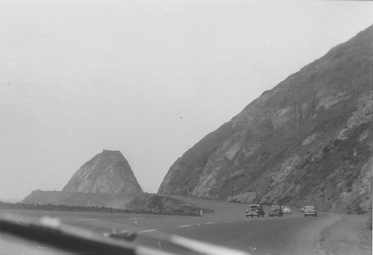
Northbound PCH Just South of Mugu Rock: 1950 and 2019

Mugu Rock came into existence in 1940 when a 200 foot cut was made into the mountain. Today it is an iconic scene that is often seen in auto commercials.

Taken on July 2, 1950, this is a view of Mugu Rock from the shoulder of northbound Pacific Coast Highway (SR 1). From a private collection. And below it is the same view, remarkably similar, 69 years later, on April 20, 2019. Thankfully, some things never change.

Mugu Rock 7.2.50.jpg
Mugu Rock 4.20.19.JPG

Lewis Road Pedestrian Overcrossing in Agoura Hills

This is the Lewis Road Pedestrian Overcrossing, Caltrans Bridge #53-998, in Agoura Hills. It connects Roadside Drive at Lewis Road on the south to Canwood Street at Lewis Road on the north side of the 101. It was built in 1963 and expanded in 1973.

This is the only pedestrian bridge going over a freeway in the Conejo Valley. There is another pedestrian bridge in Thousand Oaks - the Luedtke Bridge over Olsen Road that connects the CLU main campus to the northern campus.

Building Pacific Coast Highway Around Point Mugu in 1923-1924

Point Mugu before and after creation of a narrow road around it in 1924.

Point Mugu before and after creation of a narrow road around it in 1924.

According to the California Highway Commission in the October 1924 issue of “California Highways,” perhaps the most dangerous and difficult piece of construction work on the California state highway system at that time was the 3800 feet of grading AROUND Point Mugu.

For those driving Pacific Coast Highway in Ventura County past Mugu Rock, there are clear signs of this old route that took automobiles on a precarious route around Point Mugu.

Peaking through the fence towards the old road around Mugu Rock.

Peaking through the fence towards the old road around Mugu Rock.

The new and still existing route was created by blasting a massive hole through Point Mugu to create Mugu Rock in 1937 to 1940.

The work to complete this section of the Oxnard to San Juan Capistrano PCH route was authorized by a bond issue in 1919.

The project averaged 60 workers who moved 108,000 cubic yards or rock at a total cost of $108,500 (heck, that would be the cost of a pool addition and new kitchen remodel today). The cut around Point Mugu ranged from 40 feet on the ocean side to 115 feet on the high side in creating the narrow, short-lived roadway.

The California Highway Commission ended its article by stating “…along this piece of rugged coast line the Old Pacific is recognized as an arch enemy to whom we must trust as little as possible of our costly highway.”

Mugu Rock Then and Now

Mugu Rock is a large rock formation formed when a 200 foot deep cut was made into the rocky ridge from October 1937 to February 1940. Prior to the modern day PCH at Mugu Rock (at the time called U.S. 101 Alternate (State Route 60), drivers went around a 275 foot radius curve that is now fenced off.

The photos in the video above from the October 1940 edition of California Highways and Public Works show what it looked like before, during and after the cut was made, compared to what it looks like today.

Hillcrest Brush Fire Historical Landmark Markers in the Conejo Open Space in Thousand Oaks

There are five historical landmark markers in the Hillcrest Open Space in Thousand Oaks in tribute to firefighter Angel Castro. On December 10, 1978, Castro was severely burned while fighting the Hillcrest Fire, which burned 100 acres in two hours on a windy day with erratic gusts up to 40 MPH. He was working as a "Dozer Swamper," hauling and unloading heavy equipment. As a result of his injuries, he recommended several modifications to operating procedures that VCFD implemented. Further down this path are four other markers with questions to help challenge and educate firefighters and civilians.

The Hillcrest Open Space Preserve trailhead is located on Hillcrest Drive, just west of Blue Mesa Street, about half a mile west of Westlake Boulevard.

LOCAL AREA TRAILS AND HIKES THROUGHOUT VENTURA COUNTY

The Ventura County Portion of State Highway Route 1 is Named "Ventura County Vietnam Veterans Memorial Highway"

California State Route 1 runs along most of the coastline of California and at 656 miles is the longest state route in California. The section of SR 1 between I-5 in Dana Point and the US 101 near Oxnard is designated Pacific Coast Highway.

Sign at the indicating the north end of southbound PCH, where it connects to Las Posas Road.

Sign at the indicating the north end of southbound PCH, where it connects to Las Posas Road.

In 2002, the state assembly voted to designate the section of State Highway Route 1 in Ventura County as the “Ventura County Vietnam Veterans Memorial Highway” in gratitude and appreciation for the sacrifices California Vietnam veterans.

VC Vietnam Veterans Highway1.JPG

That same bill also designated the portion of State Highway Route 126 between the City of Santa Paula and State Highway Route 101 as the Korean War Veterans Memorial Highway.

U.S. 101 in Ventura County is Designated "The Screaming Eagles Highway"

Screaming Eagles Sign.JPG

As you drive U.S. Route 101 northbound in the Conejo Valley just past the Westlake Boulevard offramp, you’ll see a sign that says "The Screaming Eagles Hwy 101st Airborne Division."

The sign was authorized by Assembly Concurrent Resolution No. 54 (ACR-54) Screaming Eagles Highway: 101st Airborne Division, in 2003.

The 101st Airborne Division ("Screaming Eagles") is a specialized modular light infantry division of the U.S. Army trained for air assault operations. It was formed in World War I on July 23, 1918 and has been involved in every major U.S. war since then.

The 101st Airborne Division was instrumental in the success of the D-Day Invasion, the Operation Market Garden in Holland, in Bastogne for the Battle of the Bulge, in Vietnam for Operation Nevada Eagle, and in many other courageous missions worldwide. 

In recognition of the 101's significance for military personnel of the 101st Airborne Division, the Assembly designated the 44 mile section of the 101 in Ventura County as the Screaming Eagles Highway.

The sign was unveiled in September 2005. The same sign is placed on the southbound 101 just south of the Bates Road offramp on the Ventura/Santa Barbara County border.