White Horse Canyon Trail in Westlake Village

The White Horse Canyon Trail trailhead is located off of Potrero Road, just east of the little bridge next to Vista Oaks Way. From Thousand Oaks/101 take Westlake Boulevard to Potrero Road, turn right, and the bridge is less than half a mile away. Park either in allowed spots on the opposite side of Potrero Road or in an adjacent neighborhood.

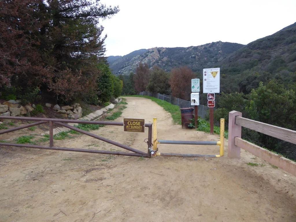
You walk into this gulley to get to the nondescript trailhead. In fact, I don't see signage that actually says White Horse Canyon Trail. But there is the following entry point that does make it clear:

WhiteHorse_trailhead.JPG

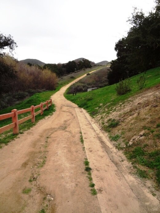
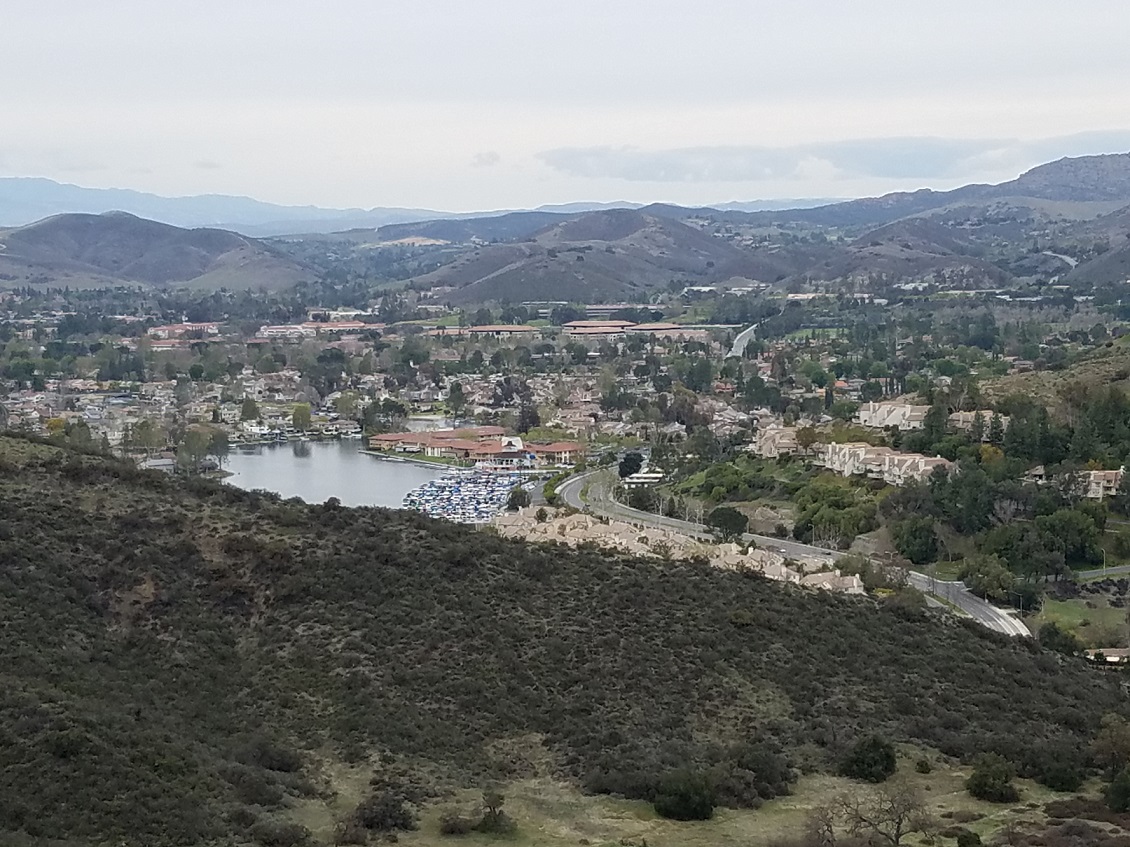
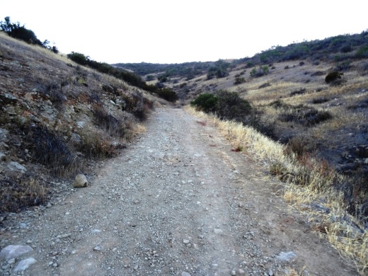
The trail is really more like a fire road, wide, somewhat rocky, but not particularly difficult. The climb gets you up to some peaks that provide views of all the surrounding areas.

Wide trail. Be aware that private residences are adjacent to the first portion of the trail.

Wide trail. Be aware that private residences are adjacent to the first portion of the trail.

You can take the White Horse Canyon Trail to the Los Robles Trail and do a 6 mile loop back the start, or you can reach the first peak at about 1,300 ft, take in the views, and turn back, for about a 2 mile hike.

WhiteHorseLookingDown.JPG

There's a nice little map showing a counter-clockwise loop from White Horse to Los Robles going east, looping back to White Horse. Visit cosf.org/trails/los-robles/los-robles-strenuous-hike-los-padres-to-white-horse-cyn.

Folks often ask me if trails are stroller friendly or not. This one in my estimation is not particularly stroller friendly because the surface is often uneven, with many loose rocks and soft dirt at times. It is do-able but not one of the better trails for that purpose...in my opinion.

WhiteHorseTrail2.JPG

County Line Beach in Solromar (Ventura County)

county line beach1.JPG

County Line Beach is located near the corner of PCH and Yerba Buena Road in Solromar, a small unincorporated community in the southwest corner of Ventura County, just northwest of the actual Ventura/Los Angeles county line.

The beach lies in between portions of the residential areas of Solromar. Solromar is the only residential community along the Malibu coast not included within Malibu city limits, yet this portion of Ventura County typically uses Malibu in its address. Neptune's Net is a well known eatery located across PCH from County Line Beach.

County Line Beach is a very popular surf spot and has about half a mile of sandy beach to enjoy. There is a dirt parking strip located off PCH that has spaces for about 15 cars; otherwise, street parking on PCH is available. There are a couple porta-johns. No lifeguards on duty here.

County Line Beach is referenced "Ventura County Line" in the 1963 Beach Boys hit, Surfin' U.S.A.

LOCAL BEACHES IN MALIBU, POINT MUGU, PORT HUENEME AND OXNARD

Santa Barbara Bowl

SantaBarbaraBowl.jpg

The Santa Barbara Bowl, located at 1122 N. Milpas Street, Santa Barbara, was originally built in 1936 and today with its capacity of nearly 4,600 people (4,974 for general admission standing) is the largest outdoor amphitheater in Santa Barbara County.

The Bowl is a beautiful outdoor setting with views of the ocean and the city. It offers top notch acts on a year-round basis and has great acoustics!

The parking lot utilized by the Bowl for patrons is located at Santa Barbara High School, less than 200 yards away from the venue. A short climb beside stone masonry walls through a beautiful glen with old oak trees leads to the amphitheater.

For more information and to buy tickets visit www.sbbowl.com or call 805.962.7411.

Nice views from the Santa Barbara Bowl too!

Nice views from the Santa Barbara Bowl too!

Ventura Botanical Gardens

The Ventura Botanical Gardens is a 107 acre site with walking paths and spectacular views of the Ventura coastline and beyond. The Gardens represent the five Mediterranean climate zones of the world - Chile, the Cape of South Africa, Australia, the Mediterranean Basin, and California.

The trail is accessible behind Ventura City Hall, located at 567 South Poli Street. Take the driveway on the right side of City Hall (facing the building) and drive up to the parking area.

You can also visit the Merewether Welcome Center, which has a gift shop full of artisan gifts, pottery, and plants.

Admission is $7 Tuesdays through Sundays from 9am to 5pm. Closed Mondays. Members, children 18 and under and EBT cardholders free. Fridays are free. Leashed dogs welcome on Wednesdays, Fridays and monthly free days. Learn more at www.venturabotanicalgardens.com.

Access to the trail is on the right (east) side of Ventura City Hall.

Access to the trail is on the right (east) side of Ventura City Hall.

A short walk will get you some pretty views!

Reagan Ranch Center Exhibit Galleries in Santa Barbara

ReaganRanchCenterGalleries.jpg

President Reagan’s home for 25 years and the Western White House during the height of the Cold War, the Reagan Ranch embodies the life and ideas of Ronald Reagan. In the spring of 1998, Young America’s Foundation stepped forward to save the Reagan Ranch; eight years later, in June 2006, the Reagan Ranch Center in downtown Santa Barbara opened its doors. 

The Reagan Ranch Center in downtown Santa Barbara is open to the general public for tours and visitation Thursdays and Fridays from 11:00 am to 4:00 pm. Admission is free.

These galleries feature original Reagan Ranch artifacts matched with state-of-the-art, interactive, multimedia exhibits that highlight the history of Ronald Reagan’s quarter-century at Rancho del Cielo and the accomplishments of his presidency.

ReaganRanchCenter1.jpg

Over six hours of dynamic multimedia exhibits provide access to exclusive speeches, interviews, radio addresses, and original video presentations. The centerpiece of the gallery is a 28-foot-long interactive “timeline” that gives users the ability to explore the “Western White House” during the 1980s.

The galleries also feature several unique collections on display, including the Lorraine Wagner Letter Collection, a nearly 300-piece collection of letters written by Ronald Reagan over a 50-year period and the Russell D. Sibert Collection, featuring rare Reagan-related memorabilia such as campaign buttons, posters and commemorative items.

A massive 5,000 pound section of the Berlin Wall greets visitors as they arrive at the Reagan Ranch Center, reminding the world of Ronald Reagan’s role in eliminating this assault on human dignity and freedom. The president’s famous blue Jeep Scrambler, complete with “Gipper” license plate, sits in the center of the gallery, flanked by a selection of his favorite books, an original saddle and chainsaw owned and used by President Reagan.

ReaganRanchGallery2.jpg

The Reagan Ranch Center is designed to engage visitors of all ages; younger children can even earn their “Junior Secret Service Clearance” by completing a fun and educational scavenger hunt.

The Reagan Ranch Center is located at 217 State Street next to the train station.

Hike to the Cross in the Hills Above Cal Lutheran University in Thousand Oaks

Views of Santa Rosa Valley from the hills above CLU.

Views of Santa Rosa Valley from the hills above CLU.

For a quick local hike and a calorie burner, try hiking to the cross in the hills above Cal Lutheran University in Thousand Oaks.

You can park in the CLU lot near the community pool at 100 Overton Court, Thousand Oaks. Then head in the direction of the adjacent baseball fields. Take the path just west of the fields towards the hills. After crossing the bridge, I veer right on the trail.

The hike itself is not particularly picturesque until you get to the top of the hill. On the east end of the hilltop is the prominent cross, along with several benches for enjoying the fruits of your uphill labor. Views extend towards the Santa Rosa Valley on the north and Thousand Oaks on the south.

You can continue your way west up the hill if you’d like. In total, the hike is about a mile to a mile and a half round-trip.

The trails are usually well maintained, though you can slip on the dirt if you don’t have decent traction on your shoes. Couldn’t hurt to bring a walking stick for the steeper, slippery parts of the hill towards the top.

So if you’re really feeling energetic, there’s a trail that takes you to Wildwood Park from these trails. See THIS LINK.

clu cross lr.JPG
As you make your way towards the hill after passing by the baseball fields, you’ll see this sign.

As you make your way towards the hill after passing by the baseball fields, you’ll see this sign.

Santa Barbara Museum of Natural History

sbnhm.jpg

Founded in 1916, the Santa Barbara Museum of Natural History makes for a great excursion to Santa Barbara with the kids.  There are eight exhibit halls with permanent exhibits featuring birds, mammals, insects, ocean life, a planetarium and more. Many of the exhibits are "hands on" with buttons and interactive features that kids particularly enjoy. There are an additional two halls for changing exhibits.

You and your kids can roam the nature paths and visit the well stocked gift shop, full of educational items. I can vouch for the fascination kids (and adults) have at this Museum. It is a very comfortable museum that in my experience is rarely is crowded. The "Museum Backyard" area and gardens has a picnic area, stream and other enjoyable features. The pond and stream often have tadpoles that captivate the kids.

The museum is open 7 days a week from 10am to 5pm and is closed certain holidays. As of May 2025, admission is $19 for adults, $17 for 65+ seniors and teens (13-17) and $14 for children 2 to 12 years of age. Become a Museum member and you don't have to pay for admission. Tax-deductible family memberships are currently start at $109 per year.

Santa Barbara Museum of Natural History is located at 2559 Puesta del Sol Road, Santa Barbara. More information at www.sbnature.org or 805.682.4711.

Lang Ranch/Woodridge Open Space Trails in Thousand Oaks

Looking for some spectacular trail hiking and panoramic views stretching from the Conejo Valley to the Simi Hills? Then take a look at the open space trails in the Lang Ranch/Woodridge system in the northeast portion of Thousand Oaks in the Lang Ranch area (where Avenida de los Arboles meets Westlake Boulevard).

The 1,025 acre area is maintained by the Conejo Open Space Conservation Agency (COSCA) and connects with another 8,000 acres of open space that is part of the Santa Monica Mountains. There are 10 miles of well-maintained trails that are outstanding for hiking, running and biking. The views are spectacular and you can actually hike from Thousand Oaks to Simi Valley (via the Long Canyon Trail) and Agoura Hills (Woodridge to Cheeseboro/Palo Comado).

More information about the various trails in the Lang Ranch/Woodridge Open Space on the Conejo Open Space Foundation website at cosf.org/trails/lang-ranch.

The specific trails seen below can be accessed from the Autumn Ridge trailhead at Westlake Boulevard and Autumn Ridge Drive in Thousand Oaks.

Access to this trail is at the corner of Westlake Bd and Autumn Ridge Dr

Access to this trail is at the corner of Westlake Bd and Autumn Ridge Dr

You can get a clear view of Bard Lake (Calleguas Water District Reservoir) from the Sunrise Trail, which parallels to the north of a portion of the Autumn Ridge Trail.

LangRanchTrail4.jpg
Checking out fossils on display in the open space. Pretty fun to see with the kids. The approximate spot of these fossil rocks is at THIS LINK.

Checking out fossils on display in the open space. Pretty fun to see with the kids. The approximate spot of these fossil rocks is at THIS LINK.

This bench is located at the juncture of the Sunrise and Meadow Vista Trails in the Lang Ranch Open Space and Long Canyon Trail, which is accessible via the Wood Ranch section of Simi Valley. Not a bad view, eh?

This bench is located at the juncture of the Sunrise and Meadow Vista Trails in the Lang Ranch Open Space and Long Canyon Trail, which is accessible via the Wood Ranch section of Simi Valley. Not a bad view, eh?

Trailhead at east end of Lang Ranch Parkway, to Albertson Fire Road trail.

Trailhead at east end of Lang Ranch Parkway, to Albertson Fire Road trail.

There’s another fun path I like to take in the Lang Ranch Open space. Take the Autumn Ridge Trail about half a mile and veer left at the Woodbridge Connector Trail, looping up and around to Wood Ranch in Simi Valley to the Long Canyon Trail trailhead, then back up to Lang Ranch. It’s only about 4 or 5 miles. See the map at cosf.org/files/maps/lang_ranch_trail_map.pdf for details.

Hunt Olive Tree - Historical Landmark in Thousand Oaks

When Richard Orville Hunt and his wife Mary Jane Hunt planted trees in their orchard on the Salto Ranch (currently Lynn Ranch) over 130 years ago, they probably never contemplated that one of their trees would be thriving next to the Sprouts Farmers Market (previously Circuit City) parking lot. 

Well, that's where this beautiful old timer is.  I'm not exactly sure why the Hunt Olive Tree was moved here from its prior home in 1993, but she looks like she is doing o.k.  This tree at 600 West Hillcrest was designated a Ventura County Historical Landmark #64 on January 25, 1982. It is also Historical Landmark #4 in the City of Thousand Oaks.

Richard Hunt served as postmaster of the Newbury Park Post Office (which at the time was located at his ranch) for 18 years, beginning in 1891.

So go pay homage to this lovely link to our local history en route to buying some fresh fruits, veggies and other health foods at Sprouts!

HuntOliveTree2.jpg
HuntOliveTree1.jpg

McGrath Family Farm in Camarillo

McGrathFarmhouse.jpg

McGrath Family Farm at 1012 West Ventura Blvd, Camarillo (take the Central Avenue offramp from the 101...McGrath is just south of the freeway) is a sustainable farm that grows organic fruits, vegetables and flowers for the local community.

The Farm Market is open Wednesday through Saturday, 10am to 4pm and Sunday 11am to 4pm.

We've been here numerous times over the years and I just love the fresh fruit and veggies available most of the year. You can find some nice locally grown gems here like heirloom tomatoes, strawberries, avocados and so much more.

Or pick your own for $10, plus the cost of the produce. Picking season generally starts around April 15th each year.

For more information, visit www.storeatmcgrath.com or call 805.983.0333.

McGrathProduce9.9.12.jpg
McGrath Farm Tours (as of September 2012)

McGrath Farm Tours (as of September 2012)

Feeding the animals at McGrath Family Farm.

Feeding the animals at McGrath Family Farm.

Triunfo Creek Park in Westlake Village

Owned and maintained by the Santa Monica Mountains Conservancy, the 600-acre Triunfo Creek Park in Westlake Village/Agoura contains deep oak woodland, native grasslands and blankets of wildflowers in the springtime. The main feature of the park, the Pentachaeta Trail, is named after the Pentachaeta lyonii, a federally-listed endangered flower found in the park. The yellow, daisy-like flower is found only in Southern California, and blooms between April and June.

PentachaetaTrail.JPG

An informational kiosk at the trailhead interprets the Pentachaeta lyonii, as well as other unusual wildflowers found on the site such as the Chocolate Lily, and the White Globe Lily. The site also provides access to hiking trails on the Westlake Vista parcel, also owned and managed by the Conservancy.

PentachaetaTrail1.JPG
Pentachaeta Trail to the east. Westlake Vista Trail towards the Las Virgenes Reservoir on the west.

Pentachaeta Trail to the east. Westlake Vista Trail towards the Las Virgenes Reservoir on the west.

Pretty flowers off the Pentachaeta Trail in March 2016.

Pretty flowers off the Pentachaeta Trail in March 2016.

pentachaeta1.JPG
Views from Westlake Vista Trail towards, well, but of course, Westlake Village

Views from Westlake Vista Trail towards, well, but of course, Westlake Village

Las Virgenes Reservoir in close proximity to Westlake Vista Trail.

Las Virgenes Reservoir in close proximity to Westlake Vista Trail.

The Westlake Vista Trail takes you to a fence that encloses the Las Virgenes Reservoir, where you may be treated to sounds of birds and other wildlife. Find the trail that parallels the fence up the mountain and you will be treated to gorgeous views of the area down to Westlake Lake and beyond and the Santa Monica Mountains to the south.

Views towards Westlake Lake from the Westlake Vista Trail.

Views towards Westlake Lake from the Westlake Vista Trail.

Directions: The main trailhead with kiosk is on Triunfo Canyon Road east of the southern terminus of Lindero Canyon Road. There are a small number of off-pavement parking spots there. The other end of the trail is at the west end of Triunfo Canyon Road about 1.5 miles west of Kanan Road.

Directions: From the 101 Freeway in Westlake Village exit Lindero Canyon Road. Take Lindero south to Triunfo Canyon Road. Turn left. The trailhead is located opposite Oak Forest Mobile Homes.

Visit mrca.ca.gov/parks/park-listing/triunfo-creek-park for more information.

Map courtesy of Santa Monica Mountains Conservancy at THIS LINK. (Note that Truinfo is a typo on map; actual spelling is Triunfo. But at least is was consistently misspelled not once, not twice, but seven times lol.)

Map courtesy of Santa Monica Mountains Conservancy at THIS LINK. (Note that Truinfo is a typo on map; actual spelling is Triunfo. But at least is was consistently misspelled not once, not twice, but seven times lol.)

Demolished car sitting near Westlake Vista Trail.

Demolished car sitting near Westlake Vista Trail.