
Experiencing the Mishe Mokwa Trail to Sandstone Peak Hike with My Kids
/
On the President's Day holiday I took my boys to the Sandstone Peak trailhead in the Santa Monica Mountains in Malibu for the six mile Mishe Mokwa Trail to Sandstone Peak.
I've discovered that many, perhaps even most, local residents have never heard of Sandstone Peak. They know about the prominent Boney Mountain overlooking the Conejo Valley, but the highest peak in the Santa Monica Mountain range at 3,111 feet is something new!
Well Sandstone Peak is something that you must explore at some point. Not exactly for the faint of heart, this peak provides panoramic, 360 degree views stretching from the Channel Islands, Conejo Valley, San Fernando Valley and beyond.
Perhaps the biggest challenge is getting to the trailhead. While only 12 miles from the Westlake Boulevard/101 freeway juncture, it take close to 30 minutes to get there via the winding, Decker Canyon, Mulholland Road and Yerba Buena Road. The main dirt parking lot has room for perhaps 25 cars, while there are several smaller dirt lots and some street parking available.

Once we parked, I made sure we had water and snacks packed. We started our trek around 2pm on a cool afternoon, so I also made sure to pack a second layer for us. The first section of the hike from the parking lot to the Mishe Mokwa trailhead is probably the steepest stretch of the entire hike. So of course about 27 steps into the hike my youngest (age 7) wants to stop and take a break. Uggh. But after finding some distractions on the trail, we made it to the Mishe Mokwa trailhead sign. Yippee!

View of Balanced Rock from the south.
The first half of the hike is mainly north/northeast facing and was almost entirely shaded. The trail is fairly moderate all the way to Split Rock, though there are a couple slightly "dicey" sections where the kids made my blood pressure go up a bit.
Within a few miles, you'll see the famous Balanced Rock (pictured above), a display that has you staring in amazement. How the heck that large rock balances on the smaller one is beyond me. And the photo (as well as this closer view from the north on Pinterest) does not do it justice.

Navigating one of the more narrow sections of the trail overlooking Balanced Rock
Just west of Balanced Rock is a small stream and Split Rock, a large boulder with a crack in it large enough to walk through. There's also a picnic bench here, where you can relax and replenish. In the canyons between Balanced Rock and Split Rock are the Echo Cliffs...aptly named as the echo effect in that area is quite fun to explore. Many folks hike to Split Rock, enjoy a picnic, then head back. Or you can continue onward for the full 6 mile or so loop to Sandstone Peak and back.

Split Rock, about 2 miles into the hike

The section of the Mishe Mokwa Trail between Split Rock and the Backbone Trail intersection is about 1 1/2 miles or so.

The sign telling us we are (finally) almost at the Backbone Trail, which will take us to Sandstone Peak and back to our car on Yerba Buena Road
Views from Sandstone Peak looking north towards the Conejo Valley/Ventura County
We had been heading north/northwest on the Mishe Mokwa trail and now we were heading east on the Backbone Trail. A couple times I was slightly confused by offshoot trails, but we found the way by staying on the main trails.
It's a bit of a challenge and rock climb to get to the actual top of Sandstone Peak once you reach its base (CLICK HERE for more details). And once you reach the top, looking down at the canyons below, with the kids running around, can be quite unnerving. (In fact, if your kids are really "active" you may not want to bring them to the top...kind of scary...and dangerous.) But we made it up there and survived!

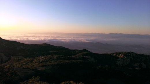
Views from Sandstone Peak looking towards the Pacific Ocean
Find out more about this and other hikes on the National Park Service Circle X Ranch website at www.nps.gov/samo/planyourvisit/circlexranch.htm, where you will find a detailed pdf map of the various hikes in that area.

Circle X area map excerpt courtesy of National Park Service. Full map with detailed information at www.nps.gov/samo/planyourvisit/circlexranch.htm.
