Anthony C. Beilenson Interagency Visitor Center in Calabasas

BeilensonCenter1.JPG

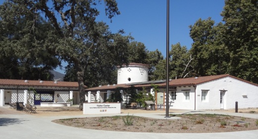
The Anthony C. Beilenson Interagency Visitor Center is located at King Gillette Ranch, 26800 Mulholland Highway, Calabasas. It opened to the public in June 2012.

BeilensonCenter2.JPG

The Visitor Center is jointly operated by the National Park Service, California State Parks, the Santa Monica Mountains Conservancy and the Mountains Recreation and Conservation Authority.

It features exhibits and interactive displays, the work of local artists, tours of sustainable features and a native plant garden. There is a tremendously comprehensive exhibit covering things to see and do within the Santa Monica Mountains.

The Visitor Center was formerly the horse stable for the Gillette Mansion. It retains some of its original design while achieving LEED Platinum certification as the first "net zero" visitor center in the National Park Service. Cool! (literally and figuratively)

Visitor Center staff and volunteers are very friendly and helpful.

There's also gift shop in the center with a variety of items including books, handmade items, kids' items and more.

Call 805-370-2301 or visit www.nps.gov/samo/planyourvisit/visitor-center.htm.

Open Wed though Sun, noon to 4pm. Closed Mon/Tues.

Nearby hiking is plentiful, including the Inspiration Point hike at King Gillette Ranch and across the street at Malibu Creek State Park.

BeilensonCenter4.JPG

Sandstone Peak to Inspiration Point and Tri Peaks in the Santa Monica Mountains

On everyone's local area bucket list should be the hike to the highest point in the Santa Monica Mountains - Sandstone Peak. That hike is about 3 miles round trip.

If you're looking to extend that hike, you can do the Mishe Mokwa Loop trail in reverse. Or you can explore several other peaks not far away - Inspiration Point and Tri Peaks. Hiking to Tri Peaks and back is about 6 miles round trip from the Sandstone Peak parking area.

Just north of the Sandstone Peak staircase/final ascent is a sign that indicates the trail to Tri Peaks. The trail is clearly marked and about 3/4 of a mile west you will come to the Inspiration Point spur trail. Do check it out as frankly I think the views towards the ocean are better here than at Sandstone Peak. Inspiration Point is 2,766 feet in elevation.

Follow the trail towards Tri Peaks from Sandstone Peak.

Follow the trail towards Tri Peaks from Sandstone Peak.

Sign on the Backbone Trail towards Tri Peaks signifying you are at the Inspiration Point spur trail. Sign indicates 2,800 ft elevation though I've read it is actually 2,766 ft. Close enough.

Sign on the Backbone Trail towards Tri Peaks signifying you are at the Inspiration Point spur trail. Sign indicates 2,800 ft elevation though I've read it is actually 2,766 ft. Close enough.

The view from Inspiration Point towards the ocean. The road below is Yerba Buena.

The view from Inspiration Point towards the ocean. The road below is Yerba Buena.

Inspiration Point dedication sign to an Eagle Scout who lost his life much too early.

Inspiration Point dedication sign to an Eagle Scout who lost his life much too early.

Another 3/4 mile or so of hiking gets you to Tri Peaks, which is 3,010 ft elevation, not too far behind Sandstone Peak. Tri Peaks is northeast of Inspiration Point and there are a number of signs that tell you you are getting close. The final sign before reaching Tri Peaks says you are .2 miles away. But after that, to my knowledge there is no official sign that says you have reached Tri Peaks. The final 1/2 mile spur trail to Tri Peaks is much more narrow than the main trail.

You have reached your destination - Tri Peaks.

You have reached your destination - Tri Peaks.

Personally when I went I was alone and in running shorts and t-shirt. Had I been wearing more appropriate hiking gear and long pants, I would have explored the peaks and caves a bit but without being properly equipped I opted to stay safe. But on the west side you can get some pretty sweet views of the Santa Monica Mountains towards Point Mugu and beyond.

Also, be careful to pay attention to the trail you came in from. There is no signage indicating the trail back, and the trail is not particularly clearly marked. 

View towards the Oxnard Plain from Tri Peaks.

View towards the Oxnard Plain from Tri Peaks.