Medieval Times Dinner & Tournament in Buena Park

Medieval-Times.jpg

Medieval Times is a family-friendly dinner attraction inspired by an 11th century feast and tournament. Guests are served a four-course banquet meal (without utensils, of course) and then cheer for one of six knights competing in the joust and other tests of skill.

You may feel like this is goofy and you're only going for the kids.....but try it out, it's actually a lot of fun and some great entertainment! The tickets aren't "cheap" but when you factor in both the dinner and the great entertainment, it is definitely worth it. We also upgraded our tickets to the VIP/Kings Feast section to get front row seating and it was great!

My 6 year old and I loved the food. Pretty basic but quite tasty menu included tomato bisque, foccacia bread, massive quantity of roasted chicken and ribs that were also quite good, potato, apple strudel and a drink. Really was good. And they do have vegetarian options too.

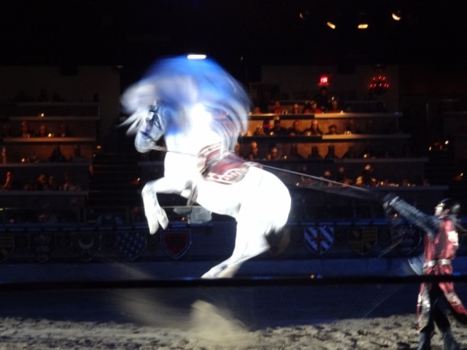
Gotta love this place. And both the animals and the actors did an amazing job! I captured some scenes from our 2012 visit below.

The Buena Park location is located at 7662 Beach Boulevard, about 60 miles from the Conejo Valley, a mile from Knotts Berry Farm and 5 miles from Disneyland. Visit www.medievaltimes.com for more information.

We are lucky to have one of only 9 Medieval Times locations in North America, with others located in Dallas, Chicago, Atlanta, Orlando, Myrtle Beach, Baltimore, Lyndhurst, NJ and Toronto, Canada.

MedTimes1.JPG
MedTimes2.JPG
MedTimes3.JPG

McCrea Ranch Visitor Center in Thousand Oaks

Opened in 2011, the McCrea Ranch Visitor Center is the former family home and ranch of Western film actor Joel McCrea and his wife and family.  McCrea Ranch is listed on the National Register of Historic Places.

The Center provides a variety of interpretive, educational, and cultural programs for the community, while preserving the unique history of this property through the Conejo Recreation and Park District. At some point and as funds become available in the future, the Visitor Center will be open to the general public. Visit crpd.org/about_us/community_partners/mccrea_ranch_visitor_center.asp for upcoming events at McCrea Ranch or call 805.495.2163.

McCrea Ranch is located at 4500 N. Moorpark Road, Thousand Oaks, near the bottom of the Norwegian Grade.

McCreaRanch1.JPG
McCreaRanch2.JPG
McCreaRanch3.JPG

Arsenal Comics & Games in Newbury Park

ArsenalComics.jpg

Arsenal Comics & Games opened its doors on September 23, 2014 and is located at 2333 Michael Drive, Newbury Park. The store serves Ventura County with comics, tabletop games, magic tournaments, Pokemon, video games and more.

I love this store because it provides such a unique array of vintage and new comics that are so fun to look at and, for many collect. 

Boardgaming 1pm to close on Sundays. Friday night magic. And other fun weekly activities.

Visit arsenalcomicsandgames.com or call 805.499.6197 for more info. Open daily 11am to 8pm.

StarCity_1.jpg
StarCity_2.jpg

Ventura River Trail

VenturaRiverTrail.jpg

The Ventura River Trail is a 6.3 mile asphalt pedestrian and bike path that follows the old Southern Pacific Railroad right-of-way from Main Street in Ventura to Foster Park inland towards Ojai. The path, originally opened in 1999, connects the Ojai Valley Trail to the Omer Rains Trail along the beachfront for 17 miles of great bicycling. The trail is open dawn to dusk.

Much of the Ventura River Trail parallels Ojai Freeway 33 and as such is also referred to as the Ojai Valley Trail Extension. Here are the various access points from south to north:

OK, so now for some commentary. This is not exactly the most exciting bike path in the world. You are paralleling Highway 33 and are kind of off the beaten path in an industrial area, but it is a peaceful path. Also, there are several stops you need to make as you cross streets, so your kids (and you) do need to be aware of that. You won't find an ocean view on this path.  But...it is never crowded, quite flat and a great way to get out on the bikes away, for the most part, from automobiles.

One of the more interesting, albeit somewhat creepy scenes along the path is this dormant USA Petroleum Refinery that was closed in 1984 after operating less than 10 years.  A bit of an eyesore this 96 acre, barbed wire fence enclosed section on the north end of the trail is. In the past there have been homeless encampments in the vicinity, but I've never seen them.

USAPetrol_view1.JPG
USAPetrol2.JPG
USAPetrol4.JPG

What I like to do is park in the free city parking lot near the Omer Rains Trail at the corner of W. Main St and Peking St, then take Main St a block east to N. Olive St, turn left (north) to Rex St. Take a left on Rex to the bike path entrance.

VenturaTrailEntry.JPG
VenturaTrailHwy33.JPG

Oakbrook Neighborhood Park in Thousand Oaks

Located at the corner of Erbes Road and Pederson Road in Thousand Oaks, the 14 acre Oakbrook Neighborhood Park was expanded dramatically in 2012. The original park included a play area, sand volleyball court and large grassy area. The expansion includes a decent-sized parking area, small restroom, basketball and netball* courts, a jogging/walking/bike path and a nice horseshoe pit area. Visit the Conejo Recreation and Park District website at www.crpd.org for more information.

OakbrookParkTOsign.JPG
OakbrookParkGrassPlayArea.JPG
OakbrookParkPath.JPG
OakbrookParkHorseshoes.JPG

This is the original section of the park; primarily expansive grassy area with play area in background.Paved path area in the expanded section of the park.Something you don't see too often these days...new horseshoe pit area .

Yes, this is a netball court, not to be confused with a basketball court!

Yes, this is a netball court, not to be confused with a basketball court!

To learn more about the game of netball, click this link. This is the first, and, as of May 2013, only netball court in Thousand Oaks. And yes, I was confused when I saw it too.

Wheeler Gorge Visitor Center and Campground in Ojai

WheelerGorge.jpg

The Wheeler Gorge Visitor Center is located at 17017 Maricopa Highway, Ojai. To reach the Center from Ventura take Highway 33 towards Ojai at the “Y” intersection (by the Vons shopping center) turn left on Hwy 33 for about eight miles.

The Center provides information about the Los Padres National Forest and also sells maps, trail guides, forest-related books, Adventure Passes and other items. It opened in June 2001. Staff are on hand to help you plan your backcountry trip planning in the area.

The Center also serves as a hub for interpretive and educational activities and programs. These include membership functions and presentations about the resources and issues of Los Padres National Forest. One of the more popular programs is the Introduction to Backpacking course.

The Visitor Center has a kitchen, classroom, library, audiovisual equipment, large parking area, outside picnic areas, and tools/equipment storage and serves as a staging area for forest projects in the southern section of the Los Padres National Forest.

The Center is open on weekends from 9am to 3pm, except Thanksgiving and Christmas. More information at lpforest.org/wheeler or call 805.640.9060.

Across the street is the Wheeler Gorge Campground, which is open year-round and offers over 60 single-family sites for tent or RV camping. Some sites are available on a first-come, first-served basis. Visit www.recreation.gov/camping/Wheeler_Gorge/r/campgroundDetails.do?contractCode=NRSO&parkId=70392 to learn more about the Wheeler Gorge Campground.

City of Ojai Recreation Department Programs and Activities

The Ojai Recreation Department provides many activities to residents of the Ojai Valley. Programs and activities include: youth day camps, youth and adult activity classes, youth and adult volleyball, softball, flag football, basketball, soccer, tennis; teen fitness center and boxing program, a downtown skateboard park, a comprehensive gymnastics program, summer aquatics programs, lifeguard training class, sports tournament throughout the year, youth excursions, horse shows and more. For more information and the latest recreation class brochure, visit www.ojairec.com or call 805.646.1872.

Oak Park Community Center and Gardens

OakParkCommCtr.jpg

Oak Park Community Center and Gardens is located at 1000 North Kanan Road, Oak Park. This is a nicely appointed indoor/outdoor facility with a 2,500 sq ft banquet room with a capacity of 140, a half court gym and recreation room and as you can see in this video, a beautifully maintained pond, waterfall, gazebo and outdoor area.  Plenty of parking available too. More information at www.rsrpd.org/oak_park/community_center/index.php or call 818.865.9304.

Palo Comado Canyon to Simi Peak Hike in Oak Park

If you're looking for a challenge, consider hiking from the Palo Comado Canyon Doubletree Road Trailhead to the 2,405 foot elevation Simi Peak in Oak Park. This is about a 4 to 4 1/2 mile trek each way with a 1,200 foot elevation gain to the top that is well worth it if you have the time and the energy.

Mind you, this particular stretch of trail, the Palo Comado Fire Road, I've rarely seen more than a handful of hikers and runners on over the years. I usually see more cyclists up here than anything. Part of the challenge is that it can get pretty hot up here on these trails as most of them get full exposure to the sun. So do bring plenty of water and wear sunscreen unless it happens to be a rare, overcast day. No restrooms either.

A quicker, easier path to the panoramic Simi Peak, the highest point in the Simi Hills, is via the China Flat Trailhead.

So if you're up to the challenge, park your car near the trailhead on Doubletree Road , just east of Clear Haven Drive, in Oak Park. From the 101, take Kanan to Sunnycrest Drive, and make a right. Sunnycrest becomes Doubletree after it veers left. The trailhead is on the right.

About a half mile from the trailhead gets you to the Palo Comado Canyon Trail, where you'll head north (left).

About a half mile from the trailhead gets you to the Palo Comado Canyon Trail, where you'll head north (left).

The Palo Comado Canyon Trail is fire road, so it is nice and wide.

The Palo Comado Canyon Trail is fire road, so it is nice and wide.

Eventually, after a bit of a grueling climb (this hike is not kid friendly if you ask me), you'll reach this corral area. Continue west (left).

Eventually, after a bit of a grueling climb (this hike is not kid friendly if you ask me), you'll reach this corral area. Continue west (left).

Follow the direction of the signs toward the Simi Peak Trail and you're on your way.

Follow the direction of the signs toward the Simi Peak Trail and you're on your way.

Follow the direction of the sign towards Simi Peak. The only challenge is that you have to go with your gut at some point as the signs stop.

Follow the direction of the sign towards Simi Peak. The only challenge is that you have to go with your gut at some point as the signs stop.

The trails get narrower and a bit more technical as you head your way to the peak. Wear good shoes.

The trails get narrower and a bit more technical as you head your way to the peak. Wear good shoes.

You've reached your destination when you see this.

You've reached your destination when you see this.

You are now at Simi Peak, the highest point of the Simi Hills. The round marker on the right is from the Ventura County Surveyor. In background is Lindero Canyon Road headed south.

You are now at Simi Peak, the highest point of the Simi Hills. The round marker on the right is from the Ventura County Surveyor. In background is Lindero Canyon Road headed south.

Fancy, green highlighted map (courtesy National Park Service).

Grandma Prisbrey's Bottle Village in Simi Valley

Grandma Prisbrey's Bottle Village in Simi Valley is a California Historical Landmark, Ventura County Cultural Landmark, is listed on the National Register of Historic Places and has a historic designation from the city of Simi Valley. CLICK HERE to learn more and to see more photos here on CVG.

BottleVillage13.JPG

Community Center Park in Camarillo

Community Center Park in Camarillo is home to the administrative offices of the Pleasant Valley Recreation and Park District, Community Center, Senior Center, classrooms and quite a nice park that is host to numerous community activities year-round. The park is nearly 13 acres and plenty of parking.

Community Center Park is located at 1605 E. Burnley Street in Camarillo. For more information, visit www.pvrpd.org/community-center-park or call 805.482.1996.

Ventura County Derby Darlins

DerbyDarlins_logo.jpg

Formed in early 2007, the Ventura County Derby Darlins is a dedicated, passionate group of women committed to the support and growth of all female, flat track roller derby.

The Derby Darlins is a not-for-profit organization, and much of the money made goes to local community charities. In fact, each skater must pay league dues in order to train and skate with VCDD.

Every hit, every injury, and every lap is real. We invite you to come out to our next event and take a seat in the front row to see the damage up close and personal. (Don’t mind the DANGER disclaimer court side!)

If you like what you see and can’t get enough VCDD, we are always looking for new players, referees, volunteers and guest coaches. Roller Derby is an awesome way to get fit, get out some of your aggressions and meet some truly amazing people. 

If you’re just in the mood to watch some amped up, jaw dropping action, the Darlins can never have too many awesome dedicated FANS!

For more information, visit www.vcderby.com. The Darlins practice at Freedom Park Rink, 528 Freedom Park Drive, Camarillo three nights a week and home games are played at Freedom Park and Ventura County Fairgrounds.

Eagle View Park in Oak Park

EagleViewPark_sign.JPG

Eagle View Park is located at 1240 Hidden Springs Avenue in Oak Park, near the very top of Lindero Canyon Road. This is a nice little neighborhood park with a basketball court, bike path, recreational trail, picnic tables and play areas. No restroom though! The park is maintained by the Rancho Simi Recreation and Park District at www.rsrpd.org.

Play area for bigger kids

Play area for bigger kids

Play area for little kids

Play area for little kids

Recreational trail accessible just southeast of the park

Recreational trail accessible just southeast of the park